|

241 DOLAUCOTHI - PUMPSAINT 
GRID REFERENCE: SN 663409
AREA IN HECTARES: 126.90
Historic Background
A small character area centred on the village of Pumsaint which is
a linear settlement either side of the A482, at the confluence of the
Afon Cothi with its tributary, the Afon Twrch. It once lay within Cwmwd
Caeo of Cantref Mawr which remained an independent Welsh lordship until
1284, and largely retained native systems of tenure throughout the Medieval
period. The A482 follows the line of the Roman road between the forts
at Llandovery (Alabum) and Llanio (Bremia), past the Roman gold mines
of Area 243 that were operational by the 1st century AD and necessitated
the construction of a fort on the level ground beneath the present village.
The fort site, Louentium, has been partially excavated (Jones and Little,
1974), and featured a detached bath-house building. Roman activity may
have influenced subsequent settlement patterns. It has been claimed (Jones
1994, 88) that some gold exploitation persisted into the post-Roman period
affecting the status of the surrounding area, which came to be regarded
as important enough to be mentioned in the marginalia of the Book of St
Chad (Jones 1994, 88), while a Medieval chapel, 'Llanpumsaint', erected
within the fort ramparts probably has pre-Conquest origins (Sambrook and
Page 1994, 4). It was a chapel-of-ease to Caeo parish mentioned in the
will of Rhys Fychan in 1271 (ibid.), and was marked on Saxton's map of
Carmarthenshire of 1578. However, there is no evidence that it was accompanied
by any nucleation. The development of the present village was probably
encouraged by the Post-Medieval development of the Roman road into an
important droving road and, from the late 18th-century, a mail road, and
by the Post-Medieval Dolaucothi estate within which the village partly
lay. The present pattern of large, regular fields also suggests estate
remodelling of the landscape. By the later 19th century Pumsaint village
contained a post office, public house, hall and stores. Dolaucothi House
occupies the valley floor to the east of the village and was established
by the Johnes family, a branch of the Jones family of Abermarlais, by
1679 when the house was already a building of some size, containing six
hearths; in 1704 it was described as 'the capital messuage called 'Tyddyn
Dole Cothi' (Jones 1987, 56). It was practically rebuilt in 1792-6 and
by 1873 the estate comprised 3172 acres (ibid.). The house was requisitioned
during the Second World War, the lead was stripped from the roofs and
it was demolished in 1951 (Whittle 1999). The grounds were taken over
by the National Trust in 1956. At the north end of the area is Brunant,
a surviving gentry house with late 16th- or 17th-century origins (Jones
1987, 15).

Base map reproduced from the OS map with the permission
of Ordnance Survey on behalf of The Controller of Her Majesty's Stationery
Office, © Crown Copyright 2001.
All rights reserved. Unauthorised reproduction infringes Crown Copyright
and may lead to prosecution or civil proceedings. Licence Number: GD272221
Description and essential historic landscape components
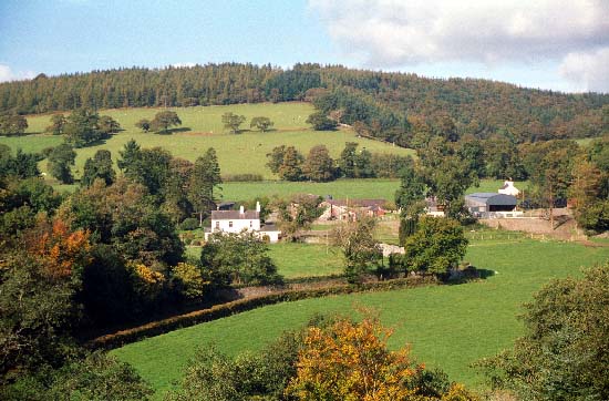
This is a relatively small but complex character area. It lies across
the valley floor and lower valley sides of the Afon Cothi upstream of
Pumpsaint village at between 120 m and 200 m. In essence it is a late
18th- and 19th-century estate landscape which is superimposed over earlier
landscape elements. There are two focii: Dolaucothi House and Pumpsaint
village. The late 18th- and early 19th-century house at Dolaucothi has
been demolished, except for a northern wing which now serves as a farmhouse.
A coach house also survives. Many elements of the park and gardens associated
with the house also survive, including a walled garden, a ha-ha, drives
and possible landscaping for walks along the river. The most distinctive
element of the park, however, is the planting, with many fine specimen
trees remaining. The whole of the floodplain of the Cothi retains a parkland
appearance. At the northeastern end of the area the early 19th-century
gentry house of Brunant and its setting continue the parkland aspect to
the Cothi floodplain upstream of the former house of Dolaucothi. A Roman
fort lies beneath Pumpsaint village, but little surface evidence for it
survives. Houses and other buildings in the village date mainly to the
mid 19th-century, and were constructed by the Dolaucothi estate with a
distinctive signature - a 'pattern-book' style of coursed rubble walls,
steeply pitched slate roofs, barge- and facia-boards (red painted) and
casement windows with diamond panes. A chapel in the village dates to
1875, and close to it is a terrace of late 19th-century two-storey 'villa'
houses not in the estate style. 20th century development is limited to
a corrugated iron - tin - village hall and a few houses. Outside the village
and parkland the area is divided into small irregular fields of improved
pasture by earth banks topped by hedges. Hedges are not in good condition
apart from those alongside roads and tracks. Many have long gaps and others
are derelict. There are many distinctive hedgerow trees. Dispersed farms
and other dwellings are generally in the Dolaucothi 1850s 'pattern book'
style. Outbuildings to the farms are in the same style. Apart from the
A482 road which runs through Pumpsaint village, transport links are local
- minor roads, lanes and tracks.
Recorded archaeology provides great time-depth, with nearly all periods being represented. It comprises a Neolithic findspot, a Bronze Age standing stone, the Roman road, fort, baths and coin hoard, the Medieval chapel site, an unknown cropmark, parkland features associated with the Dolaucothi estate, and buildings.
There are many distinctive buildings, most of them constructed on behalf of the Dolaucothi estate. The house at Dolaucothi has gone but the site represents an early 19th-century parkland with remnants of possible lime avenue, two enclosed gardens extant c. 1770, totally remodelled c. 1790, and altered and improved in the early 19th-century. The walled garden is partially intact and the whole is entered as ref. number PGW (Dy) 1 (CAM) in the Cadw/ICOMOS Register of Parks and Gardens of Special Historic Interest in Wales (Whittle 1999). The stable block, carthouse, lodge and home farm are Grade II listed. Brunant, which contains 16th- or 17th-century elements, is also Grade II listed. There are 14 other Grade II listed buildings within the character area including Salem chapel from 1875, the public house, village hall, post office, stores, war memorial, forge and K6 telephone kiosk.
Although this area has very distinct historic components, its boundaries are not well defined; it merges with neighbouring areas to the northeast, east and southwest, but is better defined to the south against Dolaucothi Gold Mines.