|

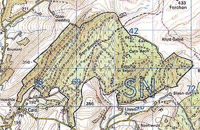
245 CAEO FOREST 
GRID REFERENCE: SN 697409
AREA IN HECTARES: 618.70
Historic Background
An area of planted coniferous forest occupying the western flank of Mynydd
Malláen. It once formed part of Cwmwd Caeo of Cantref Mawr which remained
an independent Welsh lordship until 1284 and largely retained native systems
of tenure throughout the Medieval period. It is an upland area, now unenclosed
except for the valley of the Afon Annell along which lie a series of small,
rectilinear fields of unknown date and an aqueduct which supplied the
Roman gold mines in Area 243 (Burnham 1993). Recent fieldwork undertaken
by Archaeoleg Dyfed Archaeological Trust, however, suggests a density of land-use
and population during the Post-Medieval period exemplified by a number
of abandoned early dwellings/farmsteads and some evidence for enclosure.
In addition, evidence for Bronze Age occupation exists in the form of
ritual features (round barrows). The area has no recent settlement but
now lies entirely beneath later 20th century coniferous plantation.
Base map reproduced from the OS map with the permission
of Ordnance Survey on behalf of The Controller of Her Majesty's Stationery
Office, © Crown Copyright 2001.
All rights reserved. Unauthorised reproduction infringes Crown Copyright
and may lead to prosecution or civil proceedings. Licence Number: GD272221
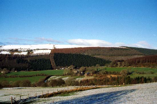
Description and essential historic landscape components
This is a large area of 20th century forestry, lying between 200 m and
400 m. Prior to afforestation most of the area consisted of open moorland,
but at lower levels, particularly in the upper Annell valley, the plantation
was established over former fields and settlements. Here field boundary
banks survive beneath the trees, and there is also here some ancient deciduous
woodland intermixed with the plantation. The main components of this landscape
are, however, the plantation and associated roads and drives.
Recorded archaeology comprises two Bronze Age round barrows, a Roman aqueduct, Post-Medieval, rectangular buildings/farmsteads and folds. There are no standing buildings.
This area has hard-edged boundaries to the northwest where it runs against semi-open land and to the southwest against the fields and farms of Caeo. To the north and northeast the forestry borders a large tract of open moorland.. On other sides the character areas have yet to be defined.