|

253 DYFFRYN COTHI 
GRID REFERENCE: SN 644382
AREA IN HECTARES: 1329.00
Historic Background
A large landscape area mainly comprising the upper Afon Cothi floodplain.
It once lay within Cwmwd Caeo, specifically Maenor Llansawel, of Cantref
Mawr which remained an independent Welsh lordship until 1284 and largely
retained native systems of tenure throughout the Medieval period. The
area appears to have good evidence for an early Medieval history and significance.
The A482 follows the line of the Roman road that linked the forts at Llandovery
(Alabum) and Llanio (Bremia), which was later an important droving road
and, from the late 18th-century, a mail road. There is a an early Medieval
cemetery site and a 6th century ECM at Maesllanwrthwl. Another ECM near
Crugybar commemorates Paulinus, the reputed teacher of St David who founded
a community which, by the 9th century, had grown to include 'numerous
buildings' (Sambrook and Page 1995, 4). Although this community did not
necessarily lie within Caeo parish, the area may represent his 'patria'.
The commote of Caeo appears to have formed the core patrimony of the Princes
of Deheubarth; Gruffydd ap Rhys, son of Rhys ap Tewdwr, the King of Deheubarth
slain by the Normans in 1093, was allowed to retain the commote by Henry
I (Ab Ithel 1860), and a llys place name lies within this area. The northern
half, moreover, is probably the location - as the place-names Bryn-Telych
and Cefn-Telych - of the 'Tir Telych' mentioned in the marginalia of the
Book of St Chad, which was possibly an important holding with place-name
evidence for land-use and ownership (Jones 1994, 88). The importance which
must have been attached to the Roman gold mines in Area 243 appears to
have continued into the post-Roman period (Sambrook and Page 1995, 4).
The ecclesiastical significance of the area did not diminish in the post-Conquest
period; land at 'Trallwng Elgan', with a chapel, was granted to Talley
Abbey as a grange, but its precise location has yet to be firmly established.
It may have occupied the site of the later Edwinsford Mansion (Jack 1981,
125; Rees 1932), or the later Glanyrannell Mansion (Richards 1974, 114),
where a further chapel with probable pre-Conquest origins, Capel Teilo,
was located (Rees 1932). Edwinsford was acquired by the Williams family
in the 16th century (Jones 1987, 61) and by the 18th century the estate
included the southern part of this character area. The impact of the estate
upon the landscape was profound involving tree-planting on an extensive
scale, in particular the planting of oak and elm during the 18th- and
19th-century which included an oak avenue leading to the mansion house
(Lewis, 1833). Glanyrannell, which had been established by 1609 (Jones
1987, 79), occupied much of the northern half of the area under the Price
Jones family. It was rebuilt at the end of the 19th century; an earlier
house stood at Beli-ficar from which the front door was re-used. The house
site is now a hotel. Samuel Lewis, in 1833, noted that the area was 'for
the greater part enclosed and in a state of good cultivation' (ibid.).
Nevertheless, it is clear that much of the present enclosure occurred
between 1838 and 1887 (Ordnance Survey 1:2500 First Edition). The tithe
maps for Llansawel and Talley parishes, of 1838, show boundaries defining
much larger fields than at present, more like blocks of open land. Doubtless
they were largely subdivided into the present fields under the impetus
of estate management. Crugybar was mentioned in a will of 1271 (Sambrook
and Page 1995, 3) but there is no evidence of any early settlement. It
is a good example of a new rural settlement of the 19th century in which
a post office was built next to a nonconformist chapel (originally from
1688), around which a village subsequently developed. 20th century development
includes a council estate.
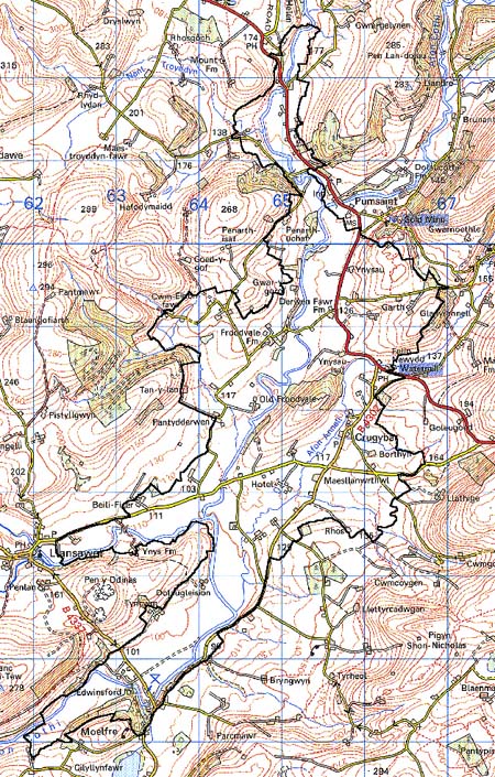
Base map reproduced from the OS map with the permission
of Ordnance Survey on behalf of The Controller of Her Majesty's Stationery
Office, © Crown Copyright 2001.
All rights reserved. Unauthorised reproduction infringes Crown Copyright
and may lead to prosecution or civil proceedings. Licence Number: GD272221
Description and essential historic landscape components
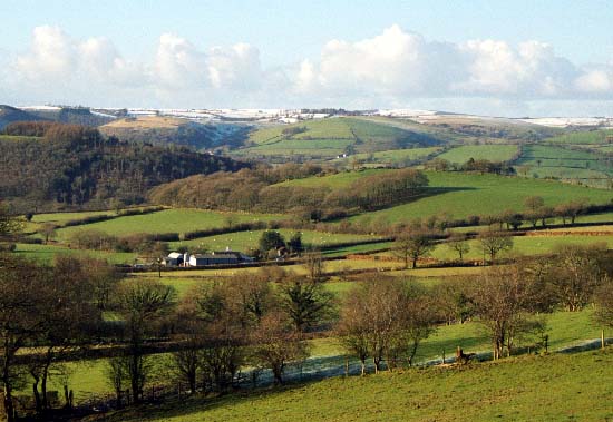
This character area lies across the valley floor and lower valley side
of the Afon Cothi and its tributaries - Afon Marlais, Afon Twrch and Afon
Annell - between Edwinsford and Pumsaint. The valley floors comprise floodplains
up to 1km wide and lie at between 90 m and 120 m, the valley sides included
in this area run up to about 150m. It is a complex area, but essentially
consists of dispersed farms and fields. Fields tend to be relatively large
and regular on the valley floor and smaller and irregular on the valley
sides. Both types are enclosed by earth banks topped with hedges. Most
hedges are maintained by cutting, but many have wide gaps and are starting
to become derelict. At higher elevations such as on Allt Ynysau hedges
are reduced to straggling lines of bushes. Wire fences provide the main
stock-proof boundaries. Farmland is almost entirely improved pasture,
apart from a little rough ground on the Marlais floodplain. Other than
a couple of small conifer plantation on high ground, woodland is limited
to small rather scrubby deciduous stands; these are mostly located on
the steeper valley sides. The dominant settlement type is the dispersed
farm. Farmhouse come in a variety of types, but 19th century, stone-built,
two-storey, three-bay structures in the vernacular tradition area the
most common. Other types include substantial late 19th-century 'villa'-style
houses, and early- to mid 19th-century houses in the 'polite' Georgian
style. Stone-built farm outbuildings tend to be relatively substantial,
often of two or more ranges, and occasionally arranged semi-formally around
a yard. The only aggregate settlement is Crugybar which consists of a
loose cluster of buildings including a 19th century chapel, a short terrace
of two-storey 19th century houses, a school, other 19th century houses,
and small-scale 20th century housing. Other residential and commercial
development across the area is limited to a few dispersed 19th- and 20th-century
properties apart from Glanyrannell and Edwinsford. Glanyrannell is a 20th
century house, now a hotel, which sits in extensive parkland on the valley
floor of the Annell. Edwinsford is much more substantial. The house which
dates to 1635 with later, mostly 19th century, additions is now ruinous.
The fine collection of associated stone buildings survives, some converted
to other uses. Walled gardens, in dilapidated condition, and a fine bridge
all remain. Parkland is now much degraded and mainly represented by semi-enclosed
pasture and isolated trees on the Cothi valley floor, and woodland on
steep valley sides.
There is a wealth of recorded archaeology which provides great time-depth. It comprises two (and one possible) Bronze Age standing stones, a possible round barrow, iron age/Roman finds, and the Roman road and a cremation. Medieval sites are a llys place name, a possible motte or spoil tip, two ?holy wells, two chapel sites, a cemetery and an ECM.
There are many distinctive buildings, mainly associated with the Edwinsford and Glanyrannell estates. The earliest section of the Grade II* listed Edwinsford house, built c. 1635, has a square plan with a vast central chimney. The dairy, home farm, coach house, dovecote, walled garden, sundial and house 'Ty Peggi' are independently Grade II listed. The 18th century bridge is Grade II* listed and the entire park is entered as ref. number PGW (Dy) (CAM) in the Cadw/ICOMOS Register of Parks and Gardens of Special Historic Interest in Wales (Whittle, 1999). The 18th century Glanyrannell Farm, its barn range, cowshed and cooling house are all independently Grade II listed. Crugybar chapel, from 1785, and railings are both Grade II listed, as are four terraces within the village, from 1867. Beili-ficer, Felin-newydd mill from c.1810, and the milestone at Maesllanwrthwl, are also Grade II listed. There are several other unlisted major dwellings, bridges, tollhouses, a mill, a council estate, post office, a school and school site, and a former smithy.
This is not an easy area to define. Although character areas have only been defined and described to the northeast, on all sides there is a zone of change rather than a hard-edged border between this area and its neighbours.