Home > Historic Landscape Characterisation > Carmarthen Bay Estuary Area > |

 MORFA BYCHAN
GRID REFERENCE: SN 195081
AREA IN HECTARES: 192.5
Historic Background
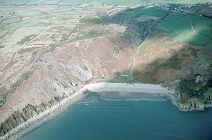
An area of Marros parish that, during the historic period, has always belonged to the Lordship of Laugharne. As this land lies on cliff top, steep coastal slopes and steep valley sides, and contains low cliffs and scree slopes, it is likely to have always been of marginal use, and it appears to have been held as common land until the 19th century. A scattering of clearance cairns (now mostly removed during land improvement), low boulder banks and deserted settlement remains on the less steep parts of the coastal slope, attest to former settlement and cultivation, perhaps in the Medieval Period (Murphy 1988). A cottage at Morfa Bychan was occupied until the late 19th-century at least (Curtis 1880). Subdivision of part of the land occurred following a Parliamentary Enclosure Award of 1864 (Chapman 1992, 71), but this had little overall effect on the landscape and the boundaries created soon fell into disuse. Further 19th century economic use of the area is attested by lime kilns and limestone quarries along the valley of Morfa Bychan, and by exploratory mining on the coastal slope below Top Castle. During the Second World War sea defences were constructed - two massive anti-tank walls survive and intertidal structures can occasionally be seen in the shifting sands on the beach. In the second half of the 20th century a small water pumping station has been constructed close to the foreshore, and a forestry plantation established at Teague's Wood.

Base map reproduced from the OS map with the permission
of Ordnance Survey on behalf of The Controller of Her Majesty's Stationery
Office, © Crown Copyright 2001.
All rights reserved. Unauthorised reproduction infringes Crown Copyright
and may lead to prosecution or civil proceedings. Licence Number: GD272221
Description and essential historic landscape components
This is a very exposed area and comprises steep, craggy valley sides and coastal slopes rising from sea level to over 125m. Land use mostly consists of moorland with ?ancient deciduous woodland on sheltered valley sides at Morfa Bychan, and a 20th century conifer plantation at Teague's Wood. Nearly all historic landscape components are relict; they consist of low boulder boundaries, a couple of earth boundary banks, limestone quarries and lime kilns, and Second World War defences.
The archaeology of this relatively small area is rich and complex, and, in addition to the relict landscape features mentioned above, includes two Iron Age promontory forts, four Neolithic/Bronze Age chambered cairns, a Bronze Age burial mound, a possible burnt mound, Medieval and Post-Medieval deserted settlements including possible long-huts, and evidence for limestone processing in the form of quarries and lime kilns.
There are virtually no buildings.