Home > Historic Landscape Characterisation > Carmarthen Bay Estuary Area > |

 MARROS MOUNTAIN
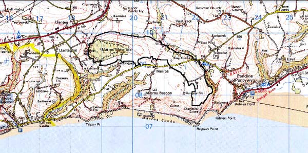
GRID REFERENCE: SN 217088
AREA IN HECTARES: 309.00
Historic Background
Archaeological survey has shown that during the Medieval period this area, which formed part of the demesne of the Lordship of Laugharne and was held under manorial tenure, was cultivated as an open field system associated with a small settlement. However by 1595, and probably even earlier, the area was under a regime of rough grazing or moorland - 'Mountain' (Laugharne Corporation) - and the settlement had been deserted (Murphy 1998). In the Post-Medieval period, probably as late as the late 18th- or early 19th-century, several small-holdings - Merrimans Gate, Thorning Pit and Ciliau-coch - were carved out of the moorland (Marros Tithe map, c. 1840). Each of the stone-built cottages of these holdings were surrounded by several small fields. These settlements were abandoned by the later 19th-century. After the Second World War a conifer plantation was established across the western part of Marros Mountain, and in the 1980s much of the evidence for the Medieval open field system was erased during land improvement. Following this land improvement several farms were constructed.
Base map reproduced from the OS map with the permission
of Ordnance Survey on behalf of The Controller of Her Majesty's Stationery
Office, © Crown Copyright 2001.
All rights reserved. Unauthorised reproduction infringes Crown Copyright
and may lead to prosecution or civil proceedings. Licence Number: GD272221
Description and essential historic landscape components
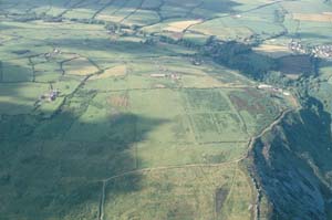
This former agricultural landscape lies across the crest and over the north- and east-facing slopes of a rounded hill which ranges in height from 70m to 145m. The greater part of the area consists of bracken and gorse moorland, though the western end is planted with a dense conifer plantation, and the eastern side has undergone much recent improvement. This improvement consists of the establishment of several farms, some with substantial agricultural buildings, complete with new systems of tracks and field systems. The farm dwellings range from temporary structures to substantial modern houses. On the northern fringes of the Mountain moorland has been converted to improved pasture and divided by wire fences. Low boundaries of a medieval field system lie on the moorland and beneath the forestry plantation.
Archaeological sites within the area are typical of moorland landscapes and include the possible sites of a Bronze Age standing stone, round barrows and ring barrows, and a possible prehistoric settlement site. Medieval and Post-Medieval sites are primarily associated with the relict agricultural landscape and include deserted cottages and farmsteads, ridge-and-furrow, and Post-Medieval field systems. There is also a Moravian meeting-house site.
None of the buildings are distinctive.
Marros Mountain is a distinct landscape area even allowing for recent land improvement. It is bordered by high quality enclosed land to the south and to the north. Only to the south-east where the Mountain borders the coastal slope and steep valley of Morfa Bychan is there difficulty in defining an exact boundary.