Home > Historic Landscape Characterisation > Carmarthen Bay Estuary Area > |

 MARROS
GRID REFERENCE: SN 199082
AREA IN HECTARES: 363.70
Historic Background
Marros formed part of the demesne of the Lordship of Laugharne, held under manorial tenure. At the death of Sir Guy de Brian, Lord of Laugharne, in 1307 it is recorded that 26 tenants held 26 carucates of land (NLW 10118E Vol. 1); a carucate is about 120 acres of arable land. Evidence from archaeological survey of Marros Mountain suggests that this arable land was cultivated under an open field or strip field system and later documentary evidence supports this suggestion (Murphy 1988, 31). A survey of 1595 (Laugharne Corporation) records just 14 tenements at Marros. The same document indicates that by then the open field system had been replaced or was undergoing replacement by consolidated holdings of small hedged fields. Thomas (1969) argues that a nucleated settlement - the village of Marros, centred on St Lawrence's Church which has elements dating to the 13th- or 14th-century (Ludlow 1998) - accompanied the open field system. If he is correct then the modern settlement pattern of dispersed farms probably dates from the 16th century, when the open field system was undergoing transformation. There may be place-name evidence for Post-Medieval coal-mining at the far south-west of the area. Several houses have been constructed in the area in recent years.
Base map reproduced from the OS map with the permission
of Ordnance Survey on behalf of The Controller of Her Majesty's Stationery
Office, © Crown Copyright 2001.
All rights reserved. Unauthorised reproduction infringes Crown Copyright
and may lead to prosecution or civil proceedings. Licence Number: GD272221
 Description and essential historic landscape components
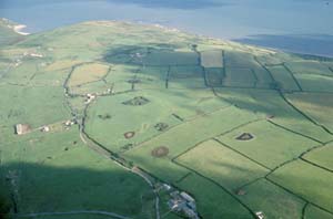
Marros lies on an undulating landscape of low rounded hills ranging in height from 40m at the extreme south-western end to over 150m in the centre. The historic landscape consists of scattered farms set in a landscape of small- to medium-sized irregular fields of improved pasture, probably with 16th century origins. Fields are defined by hedges set on earth banks. Alongside roads hedges are in good condition, elsewhere they are less good and are tending to become neglected in places and supplemented or replaced by wire fences or are overgrown. There is little woodland. There has been limited nucleation around St Lawrence's Church, mainly represented by the former church house and National School. In general, dwellings are of 19th - or 20th-century date, the older stone-built, the more recent of brick or rendered concrete. Most farms have a range of stone-built outbuildings as well as large modern farm buildings. In recent years some farmers have developed the traditional agricultural regime into a system partly based on tourism, with the construction of horse riding stables, a clay pigeon shoot and a small golf course.
There is a relative lack of diversity in the recorded archaeology. A possible ring barrow has been recorded, and there is evidence, in the form of earthwork and/or cropmark features, for several Iron Age defended enclosures. There are documented Medieval settlement(s) of various forms including the church of St Lawrence at Marros. A possible beacon site is present, and a boundary stone may mark the boundary with Pembrokeshire at Waters Edge, but Post-Medieval sites are mainly in the form of farmsteads, cottages and bridges, but include a possible mine and a possible kiln site.
St Lawrence's Church, with medieval components, is Grade II listed and is associated with the former church house and National School. None of the other buildings are distinctive; all are stone-built with slate roofs.
Marros is a well defined area as its enclosed farmland is bordered by the moorland of Marros Mountain to the north and east, the steep coastal slope and the sea to the south, and conifer and deciduous woodland to the west.