Home > Historic Landscape Characterisation > Carmarthen Bay Estuary Area > |

 LLANSTEFFAN
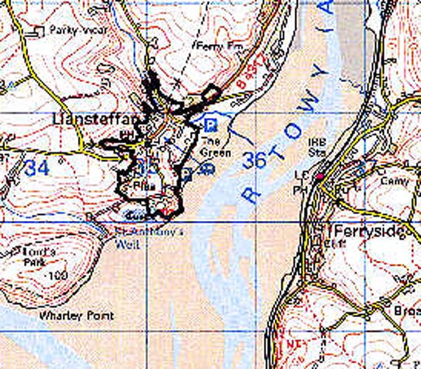
GRID REFERENCE: SN 351107
AREA IN HECTARES: 52.35
Historic Background
Llansteffan is a village dominated by a steep-sided hill to the south, whose summit is occupied by a well-preserved Iron Age promontory fort within which lies a fine masonry castle. This had been established by the Normans by 1146, as the manorial caput of the commote and lordship of Penrhyn (Avent 1991, 168-72). The village has no proven early Medieval history; the church dedication is now rendered as the Celtic St Ystyffan - said to have been a follower of St Teilo - but the original dedication may have been post-conquest and to the Latin St Stephen (Ludlow 1998). The 'discovery of the tombstone of Hywel Dda' at the church, reported in 1876, is entirely spurious. It was a parish church during the post-Conquest period and was granted, in c.1170, to the Knights Hospitaller at Slebech Commandery by the then Norman Lord of Llansteffan, Geoffrey Marmion (Ludlow 1998). The Slebech grant included a fishery and ferry across the Afon Tywi. The Marmion lords had been succeeded by the de Camvilles by the late 12th century (Avent 1991, 174), and the castle was occupied into the 16th century. By the latter part of this century, however, a mansion house, 'The Plas', had been established on more level ground to the north of the castle, and was the main seat of the Lloyds of Llansteffan until it was rebuilt further to the south in the 1780s (Jones 1987, 165). Llansteffan has a long tradition of shipping and was termed a port in the later Medieval period, trade with France and Spain continuing into the 17th century (James n.d.). By the 14th century Llansteffan had a market and two fairs (Rees 1932) but there is no evidence to suggest that the settlement constituted a town proper, and it was not granted a charter. Its topography in fact suggests that it was never anything more than a large village, and while some properties retain long, strip-like plans these may have arisen from tofts rather than burgage plots. In 1844 it was still a dispersed nucleation, centred around the junction by the church and bordered by a common along the shoreline, (tithe map). However the ferry was still operational (see Area 153) and in its heyday Llansteffan boasted 8 public houses (James n.d.). The present 'Green' to the north of the village is a later 19th-century creation.
Base map reproduced from the OS map with the permission
of Ordnance Survey on behalf of The Controller of Her Majesty's Stationery
Office, © Crown Copyright 2001.
All rights reserved. Unauthorised reproduction infringes Crown Copyright
and may lead to prosecution or civil proceedings. Licence Number: GD272221
 Description and essential historic landscape components
Llansteffan historic landscape area encompasses a wide variety of historic landscape components. Situated on the western side of the Tywi estuary where low sea banks protect the lower-lying elements of the settlement, Llansteffan lies on rising ground that achieves heights of 50 m at the castle. The core of the settlement is clustered around the Medieval parish church of St Ystyffan and along a single street. Dwellings, shops and public houses here are stone-built with slate roofs and predominantly date to the late 18th- and early 19th-century. A secondary historic nucleus fronts the estuary. Here, however, stone-built cottages and more substantial 19th century structures have been supplemented with late 20th-century development in a variety of styles and materials. Linking the two historic nuclei are small estates of 20th century housing, individual dwellings, sports fields and other low-key services. On the outskirts of the settlement to the south lies The Plas with its home farm and now degraded parkland. The Medieval castle of Llansteffan dominates the town high on its hill above the Tywi estuary. Medieval masonry remains of this castle are substantial, and earthworks reflect the Iron Age defensive character of the site. The steep gorse- and scrub-covered slopes of the hill on which the castle sits are included in this area.
Recorded archaeology in this area is mainly represented by buildings and former structures, but there is an earthwork complex near The Plas - a farmstead?, and an unknown settlement site to the west, while a possible dovecote is recorded in the name 'Clomendy'.
There are some distinctive buildings. The castle is a Scheduled Ancient Monument and a Grade I listed building, mainly from the 13th century. St Ystyffan's Church is a Grade B listed building with substantial medieval components. Plas mansion is a Grade II listed building from the late 18th century. Post-Medieval buildings also include former inns, one of which is Grade II listed, a mill, a pound, a smithy, non-Conformist chapels and two K6-type telephone boxes, both Grade II listed.
A well-defined landscape area being confined to the developed area of Llansteffan village, and the castle hill.