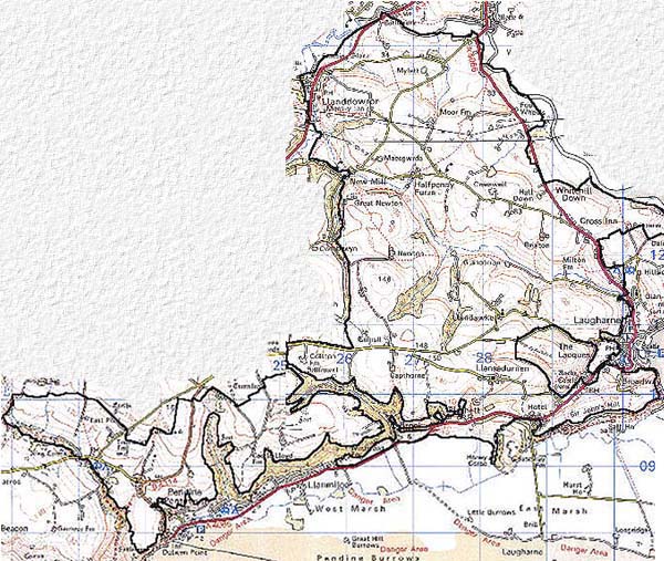
Home > Historic Landscape Characterisation > Carmarthen Bay Estuary Area > |

 LAUGHARNE PARISH, PENDINE AND
LLANDDOWROR
LAUGHARNE PARISH, PENDINE AND
LLANDDOWROR 
GRID REFERENCE: SN 280115
AREA IN HECTARES: 2528.00
Historic Background
A very large historic landscape area comprising much of the eastern half of the Medieval Lordship of Laugharne, and lying in Laugharne, Llandawke, Llanddowror, Llansadurnen and Pendine parishes. The greater part comprises Laugharne parish which, in this area, was partly common land in the Medieval period. In 1278-82, Sir Guy be Brian granted free common to the burgesses of Laugharne in lands to the north of the town almost to St Clears (Williams, n.d.; Davies, 1955). However, it is clear from a 1307 Inquisition post Mortem (National Library of Wales 10118E Vol. 1) that Sir Guy reserved arable and other lands within the parish for the demesne of Laugharne. Several places and tenants are named, though the form of settlement and field system employed is not known. It is probable that in the 13th- and 14th-century settlements consisted of small nuclei or loose clusters set in fields of shared arable, surrounded and separated by common. A small area of common survived at Broadmoor/Upper Moor in 1842 (Laugharne tithe map), but had clearly been encroached upon by squatters and much reduced in size. Some land close to Laugharne clearly consisted of open- or strip-fields; modern fields at Sir John's Hill reflect this early system and there are many references to the creation of fields from strips in 16th- and 17th-century documents in the National Library of Wales. It is likely that new, isolated farms were created with the abandonment of the open field systems. Llansadurnen parish was similarly farmed in an open field system, which according to manuscript sources was finally abandoned in the late 18th- or even early 19th-century. There is no trace of such a system in the modern landscape. In the 19th century a loose cluster of farms lay around the St Sadwrnen's church; a possible Dark Age foundation, the present church dates to 1859 (Ludlow, 1998). Pendine is in many respects similar to Llansadurnen, though documentary sources suggest that engrossing and enclosure of the open field system here was almost complete by the 18th century. The holding now occupied by Pendine Great House may be medieval - the first recorded occupant was William Barret in the earlier 16th century (Jones 1987, 147), but the house stands next to the parish church of St Margaret, with elements dating to the 12th century (Ludlow, 1998). It is not possible to ascertain the extent of any accompanying medieval settlement but in the 19th century, a loose cluster of farms and other dwellings lay around the church possibly reflecting an old settlement pattern. The isolated church of St Odoceus at Llandawke is of Medieval date, and is possibly of Dark Age foundation. In 1840 (tithe map) Llandawke was a tiny parish of one land holding. What appear to be enclosed strips show on the tithe map, indicating the former presence of an open field system. The date of enclosure of such a system and the pre-modern settlement pattern is entirely unknown. Unlike the above which in the Medieval period all lay within the Lordship of Laugharne, Llanddowror was a separate lordship (Rees 1932), which may reflect pre-conquest land division. Certainly the dedication of the church to St Teilo (or Cringat) suggests a pre-Conquest foundation. A nucleated settlement around the church was in existence by the mid 19th century, a settlement that had been given an extra lease of life by the construction of a turnpike road in the late 18th century. Documentary evidence for the existence of an open field system at Llanddowror has not been researched, and though there is physical evidence in the modern landscape to indicate such a system was employed, its date of enclosure is unknown. The essential character of this historic landscape area has changed very little since the surveys for estate maps of the late 18th century, and tithe maps of c. 1840, were undertaken. Modern dwellings have been constructed, but as these are either dispersed across the landscape replicating the pattern of old established farms, or are grouped in the semi-nucleated settlements of Pendine, Llanddowror and Llansadurnen, they tend to emphasise historic patterns.
Base map reproduced from the OS map with the permission
of Ordnance Survey on behalf of The Controller of Her Majesty's Stationery
Office, © Crown Copyright 2001.
All rights reserved. Unauthorised reproduction infringes Crown Copyright
and may lead to prosecution or civil proceedings. Licence Number: GD272221
 Description and essential historic landscape components
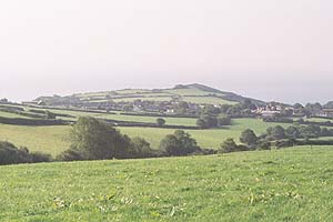
This very large area runs from a few metres above sea level on its southern fringes at Brook to over 150m at its highest point. It consists of rolling hills, sometimes with deeply incised valleys. Many of the steeper valley sides are covered with deciduous woodland, at least some of it ancient, intermixed with which are some small conifer plantations. However, the overriding characteristic of this area is enclosed pasture with a settlement pattern of dispersed farms and small villages. Fields are irregular and mostly small- to medium-sized, though with larger enclosures at higher levels. Boundaries are of variable date and consist of earth banks topped with hedges, with very occasional mortared walls. Hedges are in good condition and generally stockproof and vary from the heavily managed to the overgrown. Distinctive hedgerow trees are present in some areas, and these with the overgrown hedges and the small stands of woodland give a wooded appearance to certain parts of this area. Only at higher levels has there been some loss of hedges, but this is not severe and wire here provides the stockproof boundary. In the villages of Pendine, Llansadurnen and Llanddowror settlement is clustered around the churches. Older dwellings consist of farms and cottages of mainly 8th- and 19th-century date supplemented by later 20th-century dwellings in a variety of styles and materials. However, modern development has not overwhelmed these villages. Rural settlement is dominated by large farms dispersed across the landscape. Farmhouses are mainly of 19th century date and stone-built, often with a range of stone-built out-buildings which have been supplemented by modern farm buildings in recent years. Modern dwellings have been constructed, but in a low-key manner; and Cross Inn is the only substantial cluster of houses outside the historic villages.
In such a large area the archaeology is accordingly rich and diverse, and most periods are represented. There are a number of standing stones, and possible standing stone sites, Iron Age settlement sites, Medieval settlements, churches and mills, and a large number of Post-Medieval cottages and farmsteads.
Buildings are mainly stone-built with slate roofs. The Medieval churches at Llandawke and Pendine, which have medieval components, are Grade II listed, while that at Llanddowror is Grade B listed. However, distinctive buildings are comparatively uncommon, and there are few gentry houses. Pendine Great House, with its gate-piers, is Grade II listed, and is probably 17th century with later alterations. There are 10 more listed buildings, all Grade II and mainly agricultural but including one K6 telephone kiosk.
To the south, southwest and east this area is well defined by several landscape areas of widely differing characteristics. To the southwest lies the open moor of Marros Mountain and a steep coastal slope. To the south is modern development at Pendine and Llanmiloe, a relict, heavily wooded cliff line or reclaimed marsh. The town of Laugharne and extant or enclosed open field systems lie to the east. Definition elsewhere is problematic, there being no clear boundary - generally to the north and west there is a less coherent landscape, field size varies but tends towards the large and regular, and settlement becomes more dispersed.