Home > Historic Landscape Characterisation > Carmarthen Bay Estuary Area > |

 LLANDEILO ABERCOWIN
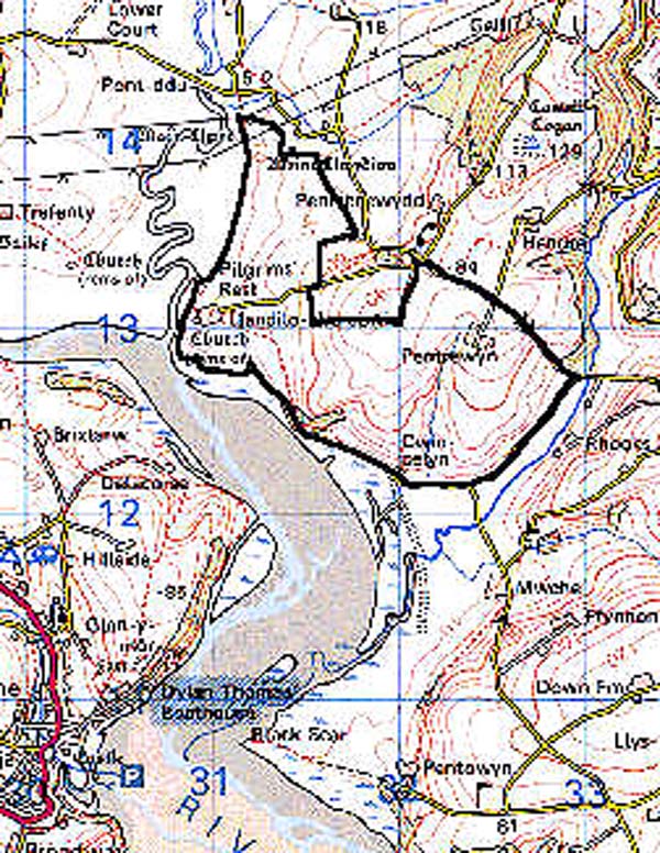
GRID REFERENCE: SN 312131
AREA IN HECTARES: 185.90
Historic Background
During the medieval period Llandeilo Abercowin was a demesne manor and sub-lordship of the Lordship of Osterlow or Ystlwyf (Rees 1932), coterminous with the ecclesiastical parish of Llandeilo Abercowin. The former parish church of St Teilo may be a pre-conquest foundation, but the present (ruined) structure is later Medieval; the church is said to have been reconstructed under Richard de Laundrey, Lord of Llanddowror and Llandeilo Abercowin in c.1270 (RCAHM 1918, 83). This area includes that part of the Lordship of Llansteffan which contained the landholding (of uncertain status) of Pentrewyn, now represented by a farmstead; it may have been the site of a further chapelry to Llansteffan apparently known as 'Eglwys Trewyn' in the 14th century (Rees 1932). By the late Medieval period the sub-lordship of Llandeilo Abercowin was owned by the Dwnns of Penallt, Kidwelly (Jones 1987, 100), who were to become one of Wales' leading gentry families and commentators. The Morgans of Muddlescwm, also near Kidwelly, had acquired the holding through marriage by 1488 (ibid.) and it may be they who were responsible for the construction of the 16th century manor house next to the church, which is traditionally (but spuriously) known as 'Pilgrim's Rest' from its location on the supposed pilgrim's route to St Davids (Hartwell Jones 1912, 372), and the possible site of a ferry to Laugharne; the manor may have been accompanied by a former settlement. The landscape is characterised by fairly large but rather irregular fields which appear to be the result of the amalgamation and enclosure of fields, possibly in part comprising open strips, since ridge-and-furrow has been recorded to the north of the area (Marshall 1985, 19). This amalgamation occurred during the 17th- and 18th-century either under the Mansels who had acquired the holding in c.1600, the Dawkins who succeeded them in 1660 (Jones 1987, 100), or their successors, from 1791, who also held Pentrewyn (ibid.). It was complete by 1840 at least (tithe map). The farm of Cwm Celyn, on the foreshore, has associations with Glyn Jones, the Anglo-Welsh author of many stories and poems set around the Taf estuary (James, n.d.).
Base map reproduced from the OS map with the permission
of Ordnance Survey on behalf of The Controller of Her Majesty's Stationery
Office, © Crown Copyright 2001.
All rights reserved. Unauthorised reproduction infringes Crown Copyright
and may lead to prosecution or civil proceedings. Licence Number: GD272221
 Description and essential historic landscape components
This is a small but nevertheless a reasonably distinct historic landscape area of fairly large fields with irregular boundaries, in an area of undulating hills that rise from the estuary of the River Taf to a maximum height of over 90m. Almost all the land is under improved pasture, apart from some small stands of secondary deciduous woodland and scrubby ground on steep slopes overlooking the estuary, and patches of rushy ground in some hollows. Dispersed farms characterise the settlement pattern, set in a landscape of medium-sized fields which tend to be regular in shape, and probably 17th- or early 18th-century in date. Boundaries to the fields consist of earth banks topped with hedges. Hedges are in good condition, well maintained with few distinctive hedgerow trees.
Additional archaeological features include elements of earlier landscapes such as the two pairs of Bronze age standing stones at the north end of this area, 'Maen Llwyd' and 'Meini Llwydion'; one of the sites has been excavated and a number of dispersed features, with little discernible pattern or function, was noted (Marshall 1985, 19). Two burnt mounds also lie near Cwm Celyn.
Pilgrim's Rest is a Grade II listed building from the 16th century with a vaulted undercroft; it is still occupied and lies next to the ruined Medieval church of Llandeilo Abercowin, of which the earliest surviving detail is from the 15th century. Other buildings are stone-built, with slate roofs, but are not distinctive and farms such as Pentrewyn, with a historic core, now consist mostly of large modern outbuildings. A Post-Medieval smithy formerly stood at the north end of the area.
Though a relatively distinct historic landscape area, it is not easy to define clear boundaries between this area and those to the east and north. There is better boundary definition to the south and west against reclaimed salt marsh.