Home > Historic Landscape Characterisation > Carmarthen Bay Estuary Area > |

 PINGED MARSH
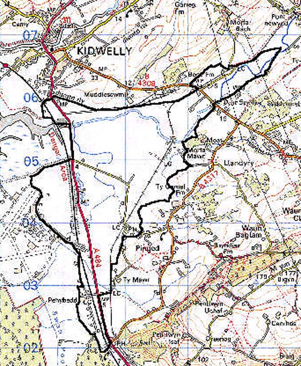
GRID REFERENCE: SN 424043
AREA IN HECTARES: 555.30
Historic Background
Pinged Marsh is a coastal lowland area of comparatively recent origin. It developed at the mouth of the River Gwendraeth Fawr behind and to the east of the great dune complex of Pembrey, over a period of time but mainly during the Post-Medieval period. The dunes acted as a sea-wall and also impeded drainage of the land behind them, which in time, because of sedimentation, could be reclaimed. The development of a marshland landscape had begun by 1609 when the area was allocated to the foreignry of Kidwelly Lordship. A contemporary survey noted 'the marsh on both sides the bridge called Pont y Spowder' (Rees, 1953, 209) ie. Spudder's Bridge, the late Medieval masonry structure that still crosses the Gwendraeth Fawr towards the east of the area. Contemporary land-use was common pasture; part of the area is depicted on an Estate Map of c.1681 where it is labelled 'Common' (James, 1991, 153) bounded by an inlet to the south-west called Salthouse Pill. 160 acres of the common had been enclosed by 1638, under the local landowner Sir Richard Vaughan and the Mayor and Burgesses of Kidwelly (James 1991, 152). The north side of the area had been drained by 1766 when the industrialist Thomas Kymer constructed his canal from Pont-iets to Kidwelly, an earthwork which still forms the northern limit of the character area. Meanwhile, Penybedd Farm at the far southern end of the area had been established between 1681 and 1841 (Pembrey tithe map). However, it is clear that much of the area was still marshland and subject to regular inundation into the early 19th-century, and much of Kidwelly's contemporary maritime trade was carried out from Frankland Quay which formerly lay on the Gwendraeth Fawr 800 m south-west of Spudder's Bridge. At least two stretches of sea defence were constructed within the area, both of them bounding drier land to the south and south-west against the Gwendraeth Fawr estuary to the north. The first is shown on the Ordnance Survey first edition and is at least 18th century in date, but it can no longer be traced. It did, however, permit the construction of a canal from coal-pits on the high ground to the south of the area, to a shipping place on the estuary, by the Lord of the Manor of Pembrey, the Earl of Ashburnham, in 1796-1801 (James 1991, 155). A short canal was established by George Bowser in 1806 from Pinged Village to a tramroad which crossed the marsh to a shipping place on the Gwendraeth Fawr. A third canal was excavated by Pinkerton and Allen in 1814-24, on behalf of the Kidwelly & Llanelly Co., between a junction with Ashburnham's Canal through Pinged Marsh to Frankland Quay. It received Bowser's Canal and had a spur leading west to Trimsaran over an aqueduct, but was replaced by a railway line in 1865 (Ludlow 1999, 30). Work on the canal was interrupted by regular inundation and as a result a further sea-wall, Banc-y-Lord, was constructed by Pinkerton and Allen in 1817-18. This is a substantial earthwork lying towards the west of the landscape area (James 1991, 156). In 1830 and 1842 private Acts of Parliament were passed to enclose parts of Pinged Marsh over which the Earl of Ashburnham's tenants had previously had right of pasture (Jones 1983, 31). However, it was not until the completion, in 1850, of the embanked A484, accompanied by the canalisation of the Gwendraeth Fawr beneath a new bridge ('Commissioners Bridge'), the construction of a further embankment along roughly the same line to carry the Great Western Railway's main South Wales line in 1852 (Ludlow 1991, 84), and an extensive Enclosure Award in 1854 (CRO AE3), that the area was finally won from the sea, but it still remains very wet and marginal.
Base map reproduced from the OS map with the permission
of Ordnance Survey on behalf of The Controller of Her Majesty's Stationery
Office, © Crown Copyright 2001.
All rights reserved. Unauthorised reproduction infringes Crown Copyright
and may lead to prosecution or civil proceedings. Licence Number: GD272221
 Description and essential historic landscape components
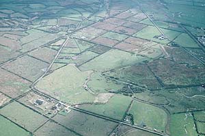
This area of reclaimed marsh consists of flat, low-lying land barely a few metres above sea level. The essential landscape components are a mixture of 18th- to 20th-century infrastructure, with post-1854 settlements and field systems. Pre-Parliamentary Enclosure features are still extant and testify to land use prior to the establishment of the present-day field- and settlement-pattern. These include the various phases of sea walls, Kymer's and Bowser's Canals, and the Pembrey & Kidwelly Canal, the latter two landscape components still evident though now derelict. Penybedd Farm is the only major pre-1854 settlement. The Parliamentary Enclosure field system of 1854 consists of small- and medium-sized regular fields, with the smaller, very regular fields to the eastern side of the area and medium-sized slightly less regular fields to the west. Ditches are the most common boundary type. These are sometimes accompanied by scrubby hedges and/or wire fences. Towards Pinged on the eastern side of the area hedges are more substantial, but generally overgrown and rarely stock-proof. Pasture is the main land use. The quality of pasture varies considerably from improved land close to Penybedd to rough, rushy ground over most of the area, through to wet ground with standing water at Pant-teg. There is no woodland. The main South Wales railway line is a prominent component of the historic landscape, as are Second World War defences, including anti-tank blocks alongside the railway.
Most archaeological features are Post-Medieval; the canals, aqueduct, sea-walls, quays and railways noted above all survive as physical evidence to varying degrees.
The masonry Spudder's Bridge is 14th- or 15th-century and a Grade II* listed building. Penybedd Farm, the only major pre 1854 settlement, consists of a stone-built farmhouse with a range of substantial stone-built outbuildings, now in poor condition. Other buildings comprise dwellings of later 19th- and 20th-century date, dispersed across the landscape; none are distinctive. Of particular note are terraces of 20th century housing built in Mansard style. In recent years a small industrial unit has been constructed.
Pinged Marsh is a distinct and well defined historic landscape character area. To the north and east it is bounded by rising ground with long-established farms and field systems. To the west lies an area of industry and leisure facilities, and salt marsh to the northwest.