Home > Historic Landscape Characterisation > Carmarthen Bay Estuary Area > |

 PEMBREY AIRFIELD
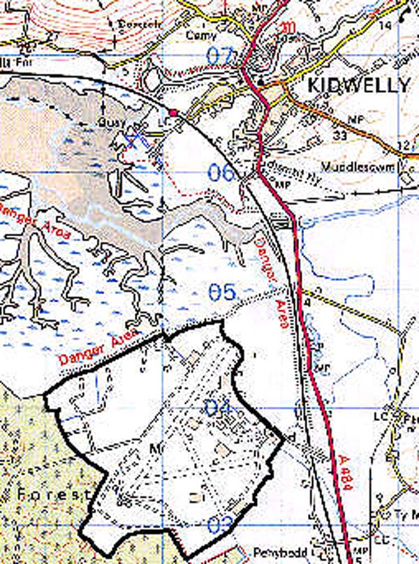
GRID REFERENCE: SN 399037
AREA IN HECTARES: 250.30
Historic Background
A small and discrete area of dune slacks behind Pembrey Burrows and occupied by the former Pembrey Airfield (Page 1996, 15). The burrows themselves are a system of sand dunes which has built up largely during the historic period, and the slacks are the result of various phases of reclamation. The landscape area is almost coterminous with the Manor of Caldicot which was first mentioned in the 13th century (Page 1996, 13), and was extended as the result of reclamation in c.1629 with the construction of a sea-defence called 'The Bulwarke'. The northern half of the area was still subject to regular inundation until a further sea-wall, Banc-y-Lord, was constructed by Pinkerton and Allen in 1817-18 (James 1991, 156). The area was later incorporated within the Manor of Pembrey, under the Ashburnham family, and is shown divided into medium-sized irregular fields on the Pembrey tithe map of 1841. Of the two farms shown on this map, one - Towyn Mawr Farm - appears to occupy the site of one of the three farms shown on an Estate Map of c.1681 (James, 1991, 153). Part of the extreme north-east section was subject to parliamentary enclosure in 1854 (Carms R O, AE3). A 19th century brick-kiln was formerly situated in the southern part of the area, presumably utilising pockets of alluvial clay (Ordnance Survey 6" first edition, Sheet LIII SW). The area was also crossed from north-west to south-east by the man-made Swan Pool Drain, which had probably been established by 1762 to empty a pond formerly lying in Area 163, to the south east, into a former creek beyond The Bulwarke. The airfield was initially a series of grassed runways established as a fighter station, but the present layout dates from 1941-44 after it had become home to 1 Air Gunnery School (Page 1996, 15, 20). It is now a motor-racing circuit and, since 1996, a light aircraft aerodrome.
Base map reproduced from the OS map with the permission
of Ordnance Survey on behalf of The Controller of Her Majesty's Stationery
Office, © Crown Copyright 2001.
All rights reserved. Unauthorised reproduction infringes Crown Copyright
and may lead to prosecution or civil proceedings. Licence Number: GD272221
 Description and essential historic landscape components
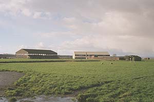
Pembrey Airfield lies on reclaimed marsh at/or close to sea level, protected from the sea by an earth-built sea wall. It is now essentially a 20th century landscape, as all earlier landscape elements were lost when the airfield was established in 1940, with two exceptions - a stretch of Ashburnham's Canal which was constructed in 1796-1801 that crosses the north-eastern corner, and Banc-y-Lord which is a substantial earthwork forming the north edge of the area. The farms and their fields recorded in 1841 and the Parliamentary Field system established in 1854, were swept away by the construction of Pembrey Airfield prior to the Second World War. Some of the major buildings from the airfield survive, mostly in a derelict state, including an 'F'-type synthetic trainer shed, but a Gunnery Training Dome survives in good condition. Parts of the runways of the airfield have been incorporated into a motor racing circuit, and other parts are used by Pembrey Airfield for light aircraft. New buildings have been constructed to serve both these functions. The area also contains a small, modern RAF headquarters/installation.
Recorded archaeology is limited to the distinctive Post-Medieval features.
The 20th century buildings are distinctive.
Pembrey Airfield is well defined to the north where a sea wall separates it from salt marsh, and to the west where it borders forestry. On other sides it is the modern components of this historic landscape character area which differentiate it from its neighbours.