Home > Historic Landscape Characterisation > Carmarthen Bay Estuary Area > |

 PEMBREY AND BURRY PORT
GRID REFERENCE: SN 438010
AREA IN HECTARES: 359.40
Historic Background
Pembrey and Burry Port, in their present form, are a product of the burgeoning coal industry of South-east Carmarthenshire during the 18th and early 19th century. Pembrey, however, has much earlier origins; the parish church is dedicated to St Illtud, and as a coastal church with early post-Conquest documentary references, may be a pre-Conquest foundation. It was granted to the Benedictines of Sherborne Abbey, Dorset, by Roger of Salisbury, Lord of Kidwelly, in 1120 (Ludlow 1998). A medieval chapelry, Capel Cynnor, formerly lay in the steep valley north of Burry Port, but its site had been engulfed beneath Cwm Capel Colliery by 1840 (Jones 1983, 18). During the later Medieval period Pembrey, with Maenor Penrhyn to the north, was at least initially held of the Lordship of Kidwelly, as both a Welshry and a foreignry (Rees 1953, 200). It enjoyed manorial status at least as early as 1361 under the Butlers, who possibly held it as a demesne manor, but by 1630 under the Vaughans it had become independent of Kidwelly Lordship (Jones 1983, 18), and was in 1896 described as a private manor with regular court leets (Jones 1983, 29). It was acquired by the Ashburnham family in 1677. Pembrey Court, the caput of the manor, lies to the west of Area 158 as 'Court Farm' and is a fine 16th- or early 17th-century masonry house, now in ruins (Lloyd 1986, 56); its lands lie outside this area. In contrast the coastal strip, 'Tywyn Bach', remained common pasture until the 19th century (Ludlow 1999, 23), and there is little further evidence of human activity until the 18th century when the lime trade with the Gower led to the establishment of several lime kilns. Of greater importance is the establishment, in the early 18th century, of coal pits at Gwscwm north of Burry Port (Ludlow 1999, 24), and a large number of further pits opened in the character area throughout the 18th- and earlier 19th-century. It was to carry this coal that a harbour was established at Pembrey, in 1819, on land acquired from the Ashburnham estate. The harbour had silted up by 1830 and a new one was established at Burry Port and was more-or-less complete by 1836, as a result of which Burry Port developed as an entirely new town. The harbour reached a peak of activity in the second half of the 19th century but began to decline after the First World War and largely ceased operations after the Second World War, most of the harbour fittings being removed during the early 1980s.
Base map reproduced from the OS map with the permission
of Ordnance Survey on behalf of The Controller of Her Majesty's Stationery
Office, © Crown Copyright 2001.
All rights reserved. Unauthorised reproduction infringes Crown Copyright
and may lead to prosecution or civil proceedings. Licence Number: GD272221
 Description and essential historic landscape components
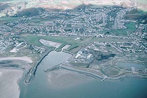
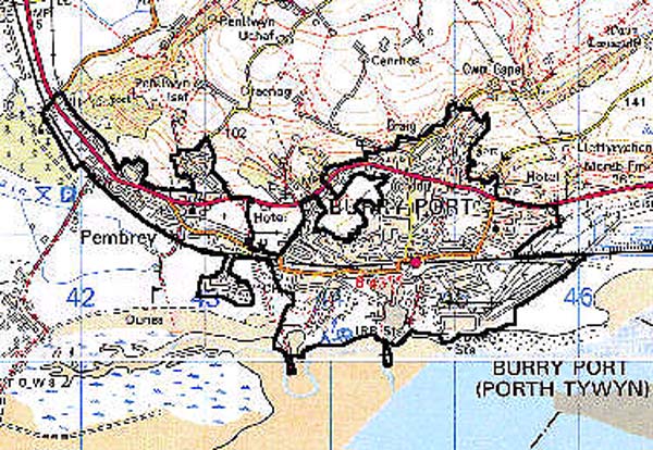
This complex, mainly urban, historic landscape character area spreads across the coastal plain and up the lower slope of coastal hills to a maximum of 100 m. It consists of several small historic industrial and residential core areas: Pembrey village, Pembrey harbour, Burry Port harbour and Burry Port village, which are now joined by 20th century development. The small nucleated core of Pembrey, which comprises the oldest settlement in the area and is centred on the church and Court Farm, have now very much been lost amongst 19th- and 20th-century development. Pembrey harbour, which was never fully developed, survives among the sand-dunes to the west of the area. Its successor, Burry Port Harbour, was dependant upon a communications network which began with canals and tramlines in the 1830s, and also featured a turnpike road. The Kidwelly & Llanelly Canal was superseded by a railway in 1866 (Ludlow 1999, 28). The service infrastructure also included a customs house, coastguard station, lighthouse and lifeboat station. Served by the above elements were a number of associated industries which began with the establishment of a copper works in the 1850s. The development of housing, and the establishment of a number of chapels and churches, began under the impetus of the proprietors of these industrial ventures from 1850 onwards (Ludlow 1999, 29). Indeed the whole area is one of terraced stone- and brick-built 19th century residential development, infilled with 20th century housing in a variety of styles and materials. Evidence for 19th- and early 20th-century manufacturing industry, and the 20th century power generation on which the settlements depended, has now virtually been erased. Its infrastructure survives, however, in the harbours themselves, for example, and the main GWR railway which opened in 1852 and is still in use. The current work on a Millennium Coastal Park will convert the semi-derelict harbours into tourist/leisure facilities, landscape the former industrial sites, and create a coastal path.
The archaeology of the landscape area is primarily connected with its industrial development and has been outlined above.
St Illtud's Church, Pembrey, is a Grade A listed building with much surviving late 16th-century detail. The 16th- or 17th-century Court Farm, that is Pembrey manor house, the largest pre-Renaissance house in Carmarthenshire 'rich in corbels, tall chimneys and mullioned windows' (Lloyd 1986, 56), is a Grade II listed building but now a shell. The outer harbour at Burry Port, and a bridge over the Kidwelly & Llanelly Canal are also Grade II listed.
Pembrey and Burry Port is a distinctive historic landscape character area and stands in sharp contrast with neighbouring areas which are predominantly rural/agricultural in character.