Home > Historic Landscape Characterisation > Carmarthen Bay Estuary Area > |

 KIDWELLY
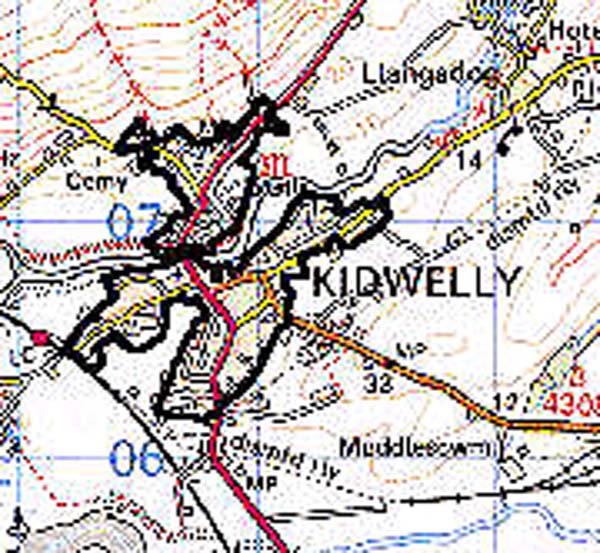
GRID REFERENCE: SN 407068
AREA IN HECTARES: 61.81
Historic Background
Kidwelly is a small town and medieval borough in which there is considerable survival of historic landscape features. It exhibits little evidence for the pre-Conquest period, although the commote within which it lies bears the same name as the settlement. In 1106 it was granted by King Henry I to Bishop Roger of Salisbury (Avent 1991, 167) who built the castle by 1114, when St Mary's Church was established as a cell of Sherborne Abbey. The civil settlement appears to have been coeval occupying a defended area that was in effect the southernmost of three outer baileys lying along the north side of the Gwendraeth Fach. Initial settlement appears to have been encouraged among Flemish immigrants, who established a cloth industry (Soulsby 1983, 153). The Kidwelly area passed between Anglo-Norman and Welsh hands during the 12th- and early 13th-century, which doubtless impeded urban development and may have prevented the expansion of the town into the northern bailey(s), but did not impede Kidwelly's role as a trading port which began in the early 13th century. The more settled conditions of the later 13th- and 14th-century, under the tenure of the Chaworths and, from 1327, the Duchy of Lancaster, permitted expansion beyond the defended area onto the southern shore of the Gwendraeth Fawr, around St Mary's Church, and a suburb also developed north-west of the defended area. No charter appears to have been preserved but in 1609 the town was referred to as 'an ancient borough' consisting of a mayor and three alderman, whose burgesses had 'very large and great privileges' (Rees 1953, 178). They were granted two weekly markets in 1268 but had been granted freedom of tolls as early as 1106-14 (Morris 1975, 62). The town defences were rebuilt in stone in the 1280s but the defended area was nevertheless 'destroyed' in the Glyndwr rebellion of 1403 (Soulsby 1983, 153). Subsequent development occurred mainly within the suburbs and by the 1530s this 'new town' was 'three times as bigge as the Old' (Smith 1910, 59), the latter accounting for only 18 burgages out of a total of 171 (Rees 1953, 179-192). Kidwelly entered into decline at the end of the Medieval period and in 1630 was, with the rest of the Lordship, sold to the Carbery earls who held it until 1804 when it passed to the Cawdor estate (Jones 1983, 18). The castle was still 'meetly kept up' in the 1530s (Smith 1910, 59) but was abandoned soon after and, with the rents in the 'old town', became decayed, while the town generally was, in 1609, described as 'very poor and out of all trade' (Rees 1953, 178). Its borough privileges, however, enabled mercantile activity to continue and there was something of a rebirth in Kidwelly's fortunes during the late 17th- and early 18th-century. Trade was conducted from the town quay on the Gwendraeth Fach below the bridge, but this proved inadequate to cope with increasing mercantile activity through the 18th century, and new quays were established on the Gwendraeth Fawr at Frankland and Muddlescwm east of the town (Ludlow 1991, 84). The establishment of Kymer's Canal in 1776-8 took yet more trade away from the town and sea-borne trade had ceased to be a factor in Kidwelly's development by the mid 19th-century. The Great Western main South Wales railway line was directed through Kidwelly, with a station, in 1859. There has been much 20th century development to the south of the river including a large, post-Second World War housing estate east of St Mary's church.
Base map reproduced from the OS map with the permission
of Ordnance Survey on behalf of The Controller of Her Majesty's Stationery
Office, © Crown Copyright 2001.
All rights reserved. Unauthorised reproduction infringes Crown Copyright
and may lead to prosecution or civil proceedings. Licence Number: GD272221
 Description and essential historic landscape components
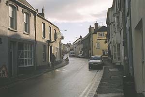
The town centres upon the castle which was later rebuilt in stone, but retains the original arrangement of an inner bailey flanked by three outer baileys in line along the north bank of the Gwendraeth Fach. All three outer baileys may initially have been intended for urban civil settlement, but only the southern appears to have been developed. The earthwork defences were topped with a stone wall in the 14th century and a late Medieval masonry house survived within the walled area until the 20th century (Williams 1991, 198). The suburb south of the Gwendraeth Fawr, along Causeway and Lady Streets, developed after the establishment of St Mary's church. Many properties within this initial suburban area, and those to the northeast of the walled area, along the Llansaint and Carmarthen Roads, appear to represent former burgage plots. Some development appears to have occurred along Station Road prior to the establishment of the station in 1859. The town hall was situated above the south gate but had been replaced by c.1600 by a new hall at the junction of Lady Street and Causeway Street (Soulsby 1983, 153-4); this has now gone. A number of mills were situated on the Gwendraeth Fach including, immediately south of the castle, a corn mill and fulling mill, the race for which can still be seen (Ludlow 1991, 84).
Recorded archaeology relates to the town's Medieval and Post-Medieval history.
Buildings are mainly 18th- and 19th-century, stone with slate roofs but distinctive buildings are few. The castle is a Scheduled Ancient Monument and Grade I listed building, the surviving town wall gateway is Grade II* listed, and St Mary's Church, fine cruciform structure, the surviving fabric of which mainly dates to the 14th century (Ludlow 1998) is Grade A listed; there is little evidence for the conventual buildings but these are not likely to have been extensive (Williams 1991, 195). There are only two more Grade II listed buildings, both 18th- and 19th-century. However, the area of the former town quay has been largely undeveloped and some of the late 18th-century warehousing still survives. Subsequent urban development along Station Road, and to the south and east of the town, occurred during the 19th century and is frequently terraced, including 'Gwendraeth Town', a terrace of worker housing erected for the employees of Kidwelly Tinplate Works in 1881 (Ludlow 1991, 84). Linear development from the 20th century connects these elements and extends beyond to the south and east.
This is a very distinct historic landscape area, and stands in sharp contrast to the surrounding agricultural land.