Home > Historic Landscape Characterisation > Carmarthen Bay Estuary Areas > |

MEUSYDD 
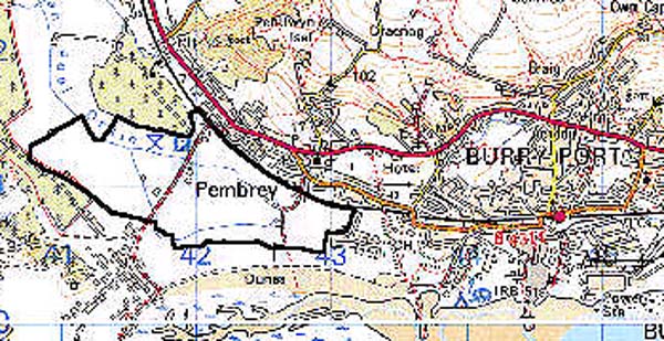
GRID REFERENCE: SN 419010
AREA IN HECTARES: 130.30
Historic Background
A character area which has developed behind and to the east of Pembrey Burrows. The eastern area comprises sand hills of comparatively recent origin, having developed since the 17th century at least but no earlier than the Medieval period (James 1991, 159). Reclamations made in neighbouring areas during the 18th- and early 19th-century, were accompanied in this area by the development of marshland and dune slacks, to the southeast of a tongue of dry land which lay at the foot of Mynydd Penbre. This area, which formed part of the Manor of Pembrey, appears to have been wet and marshy, and was partly occupied by a pond, 'Swan Pool', shown on a map of 1762 and still present at the end of the 19th century (James 1991, 154). References to the Swan Pools of Pembrey occur in manorial records of 1642 when they apparently harboured swans and fish for the table of the Lords of the Manor of Pembrey (Jones 1983, 19). The remainder of the area appears to have been called 'Black Marsh', an element which occurs in three of its present field names. A channel, 'Swan Pool Drain', had probably been constructed by 1762 in order to drain the area, and emptied into a former creek beyond the sea defences to the north-west. Reclamation of the marsh occurred after 1762 (James 1991, 154); it appears to have been piecemeal, leading to a discrete landscape area of small, irregular fields which were all under different owners/tenants in 1841, and without settlements (Pembrey tithe map). The eastern half of the area was crossed by the Pembrey Canal, which was constructed in 1823-4 to serve the former 'old' harbour at Pembrey in an area to the east (Nicholson 1991, 126). The farmstead, Meusydd, has been established since 1841 and lies adjacent to a track converted into a spur railway from the GWR main line in the early 20th-century, to serve the former Royal Ordnance Factory in Area 167 (Page 1996, 15). During the Second World War a Command Stop Line was constructed between Cardigan Bay and the Bristol Channel, part of the defences of which follow Swan Pool Drain (Page 1996, 20).
Base map reproduced from the OS map with the permission
of Ordnance Survey on behalf of The Controller of Her Majesty's Stationery
Office, © Crown Copyright 2001.
All rights reserved. Unauthorised reproduction infringes Crown Copyright
and may lead to prosecution or civil proceedings. Licence Number: GD272221
Description and essential historic landscape components
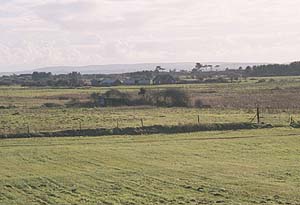
The area is a distinct landscape of reclaimed marsh just above sea level which is now unimproved pasture, divided into a patchwork of irregular roughly rectilinear fields by ditches, wire fences and post-and-rail fences. All boundaries are post-1762 and there are no mature trees. There is a scatter of dwellings and outbuildings. The northern limit of the area is defined by the embankment of the GWR West Wales main line which opened in 1852 (Ludlow 1999, 28).
Recorded archaeology is limited to the later Post-Medieval period and there appear to be no earlier landscape features. Swan Pool Drain still functions but the remains of Pembrey canal, shown in 1891 (Ordnance Survey 6" First Edition, Sheet LIII SW), are no longer clear. The railway embankment survives and there is a Second World War pillbox.
The dwellings and outbuildings are mostly 20th century, agricultural, and in a variety of materials.
This is well-defined historic landscape area bonded by Pembrey and Burry Port to the north, large enclosures to the west, and Pembrey Country Park to the south and east.