|

182 YSTRAD TYWI: CARMARTHEN - LLANDEILO 

GRID REFERENCE: SN 530209
AREA IN HECTARES: 1752.00
Historic Background
A very long, but narrow area stretching from Carmarthen in the west to
Llandeilo in the east, which lies in the fertile alluvial floodplain of
the River Tywi and includes short stretches of two of its tributaries,
the Afon Cellyn and Afon Dulas. The valley was the major historic route
corridor into West Wales. The Roman road from Carmarthen to Llandovery
followed the interface between the alluvium and the solid geology of the
north side of the Tywi, and is more-or-less followed by the modern A40(T).
The Roman road forms the northern edge of this area between White Mill
and Nantgaredig. Here it crosses alluvial deposits, which suggests that
the course of the Tywi has been fairly stable since an early period, perhaps
as far back as the Bronze Age as three round barrows are situated near
White Mill. During the Medieval period, moreover, one of the ox-bow lakes,
near Abergwili, was used as a fish-pond by the Bishops of St Davids. During
this period the river formed one of the major boundaries of Carmarthenshire,
separating Cantref Mawr on the north bank from Cantrefs Bychan (specifically
Iscennen) and Cydweli on the south bank (Rees, 1932). As such the landscape
area has experienced a chequered history of tenure, and was troubled by
warfare until the end of the 13th century. Cantref Mawr remained an independent
Welsh lordship until 1284, Cydweli had been in Anglo-Norman hands since
c.1110 but Iscennen remained nominally independent, unlike the rest of
Cantref Bychan, until 1284 (Rees 1953, xv). Three bridges cross the Tywi
between Carmarthen and Llandeilo, all with Medieval origins, and a ferry
operated at Glantowylan. The Tywi breaks its banks at least once a year.,
while the wooded nature of the valley was commented upon by contemporary
writers who appear to be including the floodplain. Leland, in the 1530s,
remarked that the Dryslwyn area for instance 'was a place ful of difficulte
and encombrance to passe through' (Smith 1906). However ridge and furrow,
which has been noted throughout the area, attests to former arable cultivation
of this very fertile soil by the later Medieval period at least. Settlement
on the floodplain itself has always been minimal but does occur on raised
'islands' within the alluvium, of which that at Glantowylan may have been
the site of a vill. Settlement, however, is mainly in the form of isolated
farms of which Beili-glas, Pentre Davis and Ro-fawr may have early origins.
The landscape had been enclosed with the present pattern of regular fields
by the time the tithe surveys were conducted in the second quarter of
the 19th century, a process which was probably undertaken during the 18th
century. No major estate cores lie within this area. Later forms of transport
also utilised the valley. A turnpike, established in 1763-71 (Lewis, 1971,
43) more-or-less followed the line of the Roman Road and the entire area
is crossed by the former LNWR main West Wales railway line which was opened,
as the 'Vale of Towy Line', by the Llanelly Railway and Dock Company in
1858 (Gabb, 1977, 76). A canal, the Golden Grove Canal, cut through part
of the eastern half of the floodplain in the 17th century, and was used
to convey coal from the Tywi to Golden Grove Mansion in Area 193 (Sambrook
1995, 75). There is, however, no real industrial history and the area
was always agricultural; leisure meanwhile is represented by an 18th-
or early 19th-century racecourse in a loop of the river at Glantowylan
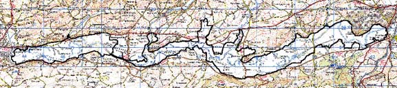
Base map reproduced from the OS map with the permission
of Ordnance Survey on behalf of The Controller of Her Majesty's Stationery
Office, © Crown Copyright 2001.
All rights reserved. Unauthorised reproduction infringes Crown Copyright
and may lead to prosecution or civil proceedings. Licence Number: GD272221
Description and essential historic landscape components
The alluvial flood plain of the Tywi was described in the Land Utilisation Survey of Britain, of 1946, as 'the best quality dairying land in the county' (Cadw/ICOMOS, 1998, 27). The area averages one kilometre in width and gains less than 20 m in height over the 20 km between Carmarthen and Llandeilo. Sections of the river are in a cycle of erosion and deposition; some meanders of the Tywi are active, and oxbow lakes are present most notably to the east of Abergwili where the Bishop's Pond is now a nature reserve, and to the west of Dinefwr Park, Llandeilo, but these are old and the majority of the flood plain is stable and has long been enclosed. The fields are small- to medium-sized and tend towards the regular, though many different patterns from the small irregular to the large regular are present. Field boundaries comprise hedges without banks and earth banks topped with hedges. The former are planted on the valley floor presumably to facilitate flood-water drainage. The condition of these boundaries varies. In some locations, such as between Abergwili and Whitemill, they are well maintained and in good condition, but elsewhere they have broken down completely and the hedges are either derelict or gone. Ditches also form some boundaries. Wire fences supplement all historic boundaries. Virtually the whole of the valley floor is now under improved pasture. Woodland is now virtually non-existent, but distinctive trees, in hedgerows, isolated or in small clumps right along the valley, but particularly those close to the estate cores of Dinefwr and Golden Grove/Gelli Aur, provide a 'parkland' aspect. Apart from 'islands' of slightly higher ground, the whole of this area is subject to at least one episode of flooding each winter. It is on these 'islands' that the several farms are located. Of the major routeways the A40(T) runs on elevated ground to the north, and the area is skirted by the B4300 to the south. The old railway line which was built on a low embankment to avoid flooding is a distinctive feature of the floodplain.
Recorded archaeology is of relatively low density. Findspots include Bronze Age finds and a Roman coin hoard. There are three Bronze Age round barrows near White Mill, one scheduled, and at least one Bronze Age standing stone. The Roman Road and the LNWR railway line survive as field evidence, and the line of the Golden Grove Canal is just visible. There are watermill sites, and two lost chapels, from the Medieval period.
There are few distinctive buildings. Of the three Tywi bridges the stone-built Pont Llandeilo Rwnws, built in 1786, is Grade II listed; there are several minor bridges. Golden Grove and Dryslwyn station buildings survive within the area and are now private dwellings, as is one of the Golden Grove lodges. There are few farmsteads and cottages but Glantowylan, Beili-glas, Pentre Davis, Ro-fawr and the home farm of Abercothi mansion, which was established by 1857 (Jones 1987, 1), are substantial. These and other farmhouses are generally 18th- or 19th-century stone-built structures in the 'polite' Georgian style. Farms have substantial ranges of stone-built outbuildings, some arranged semi-formally around a yard. Most farms have large modern agricultural buildings.
This section of Ystrad Tywi is very distinctive and has boundaries defined by the foot of the valley sides. In most locations this boundary definition is very strong, but close to Nantgaredig and on the south side of the valley near to Llandeilo there is a zone of change, rather than a distinct border.