|

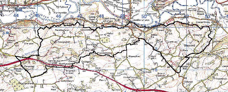
185 LLANGYNWR - LLANARTHNE PARISHES 
GRID REFERENCE: SN 485190
AREA IN HECTARES: 1207.00
Historic Background
A large area that was formerly unequally divided between two commotes, and later lordships. Kidwelly commote, represented by Maenor Cunnor (Llangynwr parish), lay to the west, and Iscennen, represented by Maenor Vouwen (Llanarthne parish) lay to the east (Rees 1953, 174). The farm 'Ffos-y-ffin' records the presence of the boundary. Kidwelly had been in Anglo-Norman hands since c.1110 but Iscennen remained nominally independent, unlike the rest of Cantref Bychan, until 1284 (Rees 1953, xv). In 1327 Kidwelly passed to the House of Lancaster followed by Iscennen in 1340 (ibid.). Despite this duality of tenure, land management during the historic period appears to have been much the same in both parts of the area, which were held as Welshries during the Medieval period (Rees 1953, 220), though some possible ecclesiastical land is recorded as a field-name in the east of the area. In fact much of the higher land immediately to the south of this area was common pasture, part of Mynydd Kyvorth and Mynydd Ucha commons, the majority of which was enclosed by a number of private individuals - major freeholders such as the Stepneys, Morgans and Philippses - during the 16th- and early 17th-century as recorded in some detail in 1609 (Rees 1953, 243-9). It is thus probable that Area 185, with its smaller, more irregular fields, was enclosed at an earlier date, possibly in the form of later Medieval encroachments. There is, however, a hafod (seasonal pasture) place-name towards the west of the area, and a hendre place-name to the east. The tithe maps of Llangynwr (1842) and Llanarthne (1848) parishes depict the then pattern of enclosures and farms to be very similar to today's. To the east of the area, a former large, single holding, Penddaulwyn, mentioned in the late 17th-century, had split up into five separate farms by the late 18th-century (Jones 1987, 147), one of which was part of the Cawdor estate. Later development has been minimal, but industrial activity is represented by a substantial number of lead mines sunk to the west of the area near Cystanog.
Base map reproduced from the OS map with the permission
of Ordnance Survey on behalf of The Controller of Her Majesty's Stationery
Office, © Crown Copyright 2001.
All rights reserved. Unauthorised reproduction infringes Crown Copyright
and may lead to prosecution or civil proceedings. Licence Number: GD272221
Description and essential historic landscape components
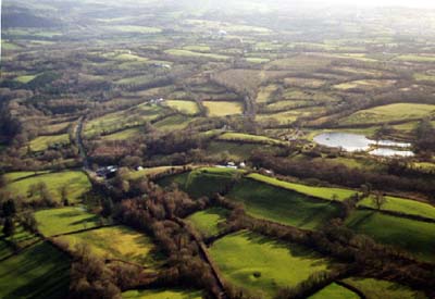
This area consists of the hilly southern valley side of the River Tywi which rises from the valley floor at approximately 20 m above sea level on its northern edge to over 140 m on the rounded hills to the south. It is a rural area with a settlement pattern of dispersed farms and other dwellings. The field pattern is one of small, irregular enclosures, possibly late Medieval in origin - as encroachments onto fairly marginal, north-facing land - surrounded by earth banks topped with hedges. Hedges are in a variety of conditions, but tend towards the overgrown and contain small trees and bushes. Some are derelict. Wire fences supplement most of these historic boundaries. There are numerous small stands of deciduous woodland and some larger stands in the north-eastern portion of the area (secondary in the shallower valleys), which together with several small conifer plantations and the overgrown hedges lends a wooded aspect and a distinctive character to this historic landscape area. Where the distribution of woodland is at its most dense and where hedges are overgrown, land-use is dominated by unimproved pasture with much rushy and wet ground. Elsewhere, particularly towards the southern and south-western boundary, improved pasture dominates, and hedges tend to be better maintained.
Recorded archaeology includes an inland Iron Age promontory fort at Cae'r Castell from which an important Class III Early Christian Monument was apparently recovered. There are possible round barrow and standing stone sites from the Bronze Age, and possible holy well and cross sites. Post-Medieval archaeology features a typical range of sites, mainly buildings, including mills, smithies, wells, bridges, farms, possible kilns, cottages, a chapel and a school.
There are few distinctive buildings. Cwm-du House was recorded in 1500 (Jones 1987, 46) but retains no early features. In the area of improved pasture the farmhouses are generally small- to medium-sized, comprising two storeys and three bays, stone-built with slate roofs, late 18th- or 19th-century in date and usually in the vernacular tradition, with an informal arrangement of stone outbuildings and modern farm buildings. On the poor quality land farms are smaller with a few but notable number of single-storey dwellings which are assumed to be of rendered stone but might be earth or clom built.
These small farms have a limited number of small outbuildings, usually in one range. This historic landscape area is fairly well defined. To the west and north lie areas of larger, richer farms set in medium-sized fields of improved pasture. The National Botanical Garden of Wales lies to the east. To the south the historic landscape area has yet to be defined, but it consists of a ridge of medium-sized fields and widely dispersed farms.