|

189 LLANARTHNE 
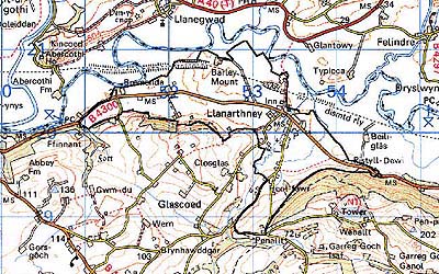
GRID REFERENCE: SN 526199
AREA IN HECTARES: 244.30
Historic Background
A small area around the nucleation of Llanarthne, roughly coterminous with an area that lay within the commote of Iscennen but belonged to the Bishops of St Davids, probably as the result of a pre-Conquest grant. Field names immediately south-west of the village containing Henllan and Llandre elements suggest the presence of a clas church, and a rectangular cropmark has been observed which belongs to a later successor. Either this, or the present church which is dedicated to St David, may be the 'Llanadneu' mentioned as a 'Dewi' church in the 12th century 'Poem to Dewi' by Gwynfardd Brycheiniog (Ludlow 1998). St Davids was not a parish church during the post-Conquest period. It was a possession of the Bishop as a prebend of the collegiate church at Brecon, appropriated to the Prior of the Knights Hospitaller in England by Bishop Thomas Bek in 1290 (Ludlow 1998). Iscennen, unlike the rest of Cantref Bychan within which it lay, remained nominally independent until 1284 (Rees 1953, xv-xvi), and native systems of tenure were maintained. The present nucleation, which is informal and rather dispersed, is therefore probably Post-Medieval in origin and only about 10 dwellings are depicted on the Llanarthne tithe map of 1848. The western half of the area is occupied by three farms bearing the name 'Bremenda' which represent the break-up of a larger holding. This appears to have occurred between 1697 and 1789 when it was a possession of the Golden Grove estate (Jones 1987, 13). The estate may be responsible for the present pattern of large regular fields which are probably 18th century in origin. The LNWR main West Wales railway line formerly passed through the area, with a station at Llanarthne. It was opened, as the 'Vale of Towy Line', by the Llanelly Railway and Dock Company in 1858 (Gabb, 1977, 76), which provided impetus for further development, although the Golden Grove Arms inn had already been established under the patronage of the estate. Small-scale development has continued into the late 20th century.
Base map reproduced from the OS map with the permission
of Ordnance Survey on behalf of The Controller of Her Majesty's Stationery
Office, © Crown Copyright 2001.
All rights reserved. Unauthorised reproduction infringes Crown Copyright
and may lead to prosecution or civil proceedings. Licence Number: GD272221
Description and essential historic landscape components
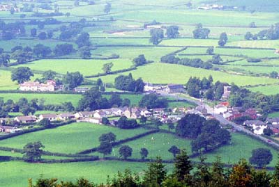
Llanarthne village and historic landscape area lies on a gently sloping terrace on the south side of the River Tywi. The northern edge of the area lies at a level of 20 m, just a few metres above the flood plain of the Tywi, while the southern limit, against the steep valley side achieves a height of 30 m - 40 m. The area is centred on the village of Llanarthne. The historic elements of the village now consist of the Medieval church and two public houses of 19th century date. Post-war housing development, mostly late 20th century and in a variety of styles and materials, surrounds the historic core and includes a council estate. The village sits in a landscape, probably 18th century in origin, which comprises medium-large fields of rich, improved pasture and dispersed farms. Earth banks topped with hedges are ubiquitous. Hedges are well maintained, and many possess distinctive trees. There is little woodland. A disused quarry lies to the west of the area. The B4300 and the abandoned LNWR railway line both run through this area.
Recorded archaeology is represented by the clas/chapel site and the present church of St David, which is Grade B listed. There is also a possible Bronze Age standing stone, a possible holy well, a fulling mill site and a possible kiln.
There are a number of distinctive buildings, including a Grade II listed smithy. Bremenda-ucha, Bremenda-ganol and Bremenda-issa are 'commodious farmhouses of superior type', much altered in the mid 19th century (Jones 1987, 13). Generally farmhouses are stone-built with slate roofs and of two storeys, of the late 18th- and 19th-century, and in the polite Georgian tradition rather than the vernacular, though examples of the latter are present. Stone-built 19th century farm outbuildings tend towards a formal layout on the larger farms, less so on smaller farms. Most farms have large modern farm buildings. Other buildings include a bridge, two inns and two chapels. The railway station has gone.
Llanarthne historic landscape area is not easy to define as its shares many historic landscape components with its neighbours. However, to the south the steep and wooded valley side of the Tywi does provide a reasonably clear-cut border between this area and its neighbours. To the north the flood plain of the Tywi is very similar to this area in many respects. Here there is a zone of change rather than a hard-edged border.