|

194 ALLT PANT MAWR 
GRID REFERENCE: SN 561195
AREA IN HECTARES: 294.10
Historic Background
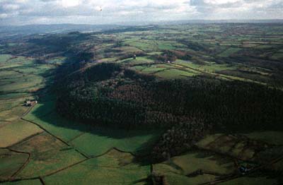
A relatively small landscape area mainly occupying steeply sloping ground to the south of the River Tywi. It lies within the parishes of Llanarthne and Llanfihangel Aberbythych in the central part of Iscennen commote which, unlike the rest of Cantref Bychan within which it lay, remained nominally independent of Anglo-Norman rule until 1284 when it was acquired by John Giffard. In 1340 it became a member of the Duchy of Lancaster (Rees 1953, xv-xvi). Rhydarwen, a farmstead at the centre of the area, has Medieval origins (Jones 1987, 171), and the pattern of small fields beneath the wooded slopes of Allt Pant Mawr may have been established before the Post-Medieval period. Visually, the west end of the area is dominated by Paxton's Tower, a folly built for the Middleton estate within Area 188. The B4300 along the south side of the Tywi valley, established by the early 19th century, passes through this area. The upper slopes of Allt Pant Mawr were subject to conifer plantation in the later 20th century.
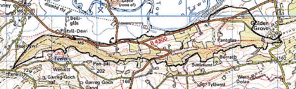
Base map reproduced from the OS map with the permission
of Ordnance Survey on behalf of The Controller of Her Majesty's Stationery
Office, © Crown Copyright 2001.
All rights reserved. Unauthorised reproduction infringes Crown Copyright
and may lead to prosecution or civil proceedings. Licence Number: GD272221
Description and essential historic landscape components
Lying on the south side of the Tywi valley, this character area consists of steep and heavily wooded north-facing slopes below which lies a sloping shelf of farmland and woodland that runs down to the flood plain of the Tywi. From the Tywi at 20 m OD the land rises to over 150 m at its southern limit. The woodland on the steep slopes is a mixture of conifer plantation and deciduous trees. The more gently sloping land, which lies in the shadow of the steep slope, is enclosed into a system of small regular fields which have a strong north-south, down-slope trend and possible early origins. Boundaries are of earth banks and hedges. Hedge quality varies from the well maintained to the overgrown and semi derelict. Wire fences supplement the hedged boundaries. Distinctive hedgerow trees are common. Some land is under improved pasture, but there is much rushy and unimproved ground, and scrubby woodland has invaded some former fields. This latter feature in combination with the distinctive hedgerow trees and conifer and broadleaf trees lends a heavily wooded appearance to the area. Settlement is one of dispersed small farms, smallholdings, cottages and other dwellings along the B4300.
There is little recorded archaeology within this predominantly sloping area, being limited to a burnt mound, a prehistoric findspot and two Post-Medieval quarries.
Distinctive buildings include Rhydarwen, a Grade II* listed medieval house, 'strongly-built' with a stair turret at each end and a 16th century wall painting (Jones 1987, 171), altered in the 18th century. Most farm buildings are 19th century, two-storey, stone-built with slate roofs in the vernacular tradition, although some in the Georgian tradition are present.
This is a distinct area, distinguished from its neighbours by its high density of woodland, its north-south aligned field system and the modest size of its farms and buildings.