|

195 DINEFWR PARK 
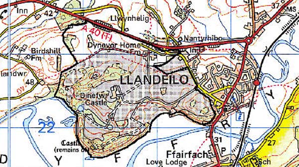
GRID REFERENCE: SN 617225
AREA IN HECTARES: 229.20
Historic Background
These background notes have been taken from Professor Ralph Griffiths's recent study (1991) of the castle and borough of Dinefwr, and from the Cadw/ICOMOS Register of Parks and Gardens of Special Historic Interest in Wales (Whittle 1999). It has long been thought that Dinefwr was the seat of the Welsh princes of Deheubarth. Griffiths has demonstrated, however, that this was not the case and that it is likely that nothing of note existed on the site until Rhys ap Gruffydd (Lord Rhys) erected a castle soon after 1163. It is possible that Lord Rhys built a masonry castle, as a reference of 1213 implies stone walls. At this date Lord Rhys's youngest son, Rhys Gryg, was besieged in the castle by two of Lord Rhys's grandsons. It is likely that the round keep at the castle was built by Rhys Gryg between 1220 and 1233. The castle remained in family hands until the reign of Edward I. Extensive repairs and additions were made to the castle by the English Crown in the 1280s. During latter years of Welsh rule a small settlement - 'Trefscoleygyon' or 'vill of the clerks' - developed outside the castle. By 1294 the town of Dinefwr had 26 burgages, a weekly market and annual fair. The end of the 13th century saw Dinefwr become a twin-town. This consisted of an 'old' town on the hill containing 11 Welsh burgesses, and a 'new' town - soon to be called 'Newton' - containing 35 burgesses of mostly English descent. Newton was located some distance away on the site of the later mansion, Newton House. In 1310 the castle, towns and demesne of Dinefwr were granted to Edmund Hakelut and later to his son. The Hakelut family held their position, apart from a short break, until 1360. Repairs to the castle were carried out under the Hakeluts. A survey of 1360 indicates that Newton was a successful settlement with 46 burgesses. A charter was granted to the towns in 1363, but this seems to have marked a high point in the towns' fortunes. The castle and towns were besieged in 1403 during the Glyndwr rebellion. Following the revolt the towns and castle were granted to Hugh Standish. The Standish family had little interest in south Wales, and both the castle and towns went into decline. In 1433 responsibility for the towns and castle was separated, and the towns and demesne were granted to John Perrot. His cousin married Gruffydd ap Nicholas, and so began the long association with the Gruffydd family. By the time that Gruffydd ap Nicholas's grandson, Rhys ap Gruffydd, was attainted of treason in 1531 his family had built a mansion among the ruins of the former town of Newton, although 'Newton' was still marked on Saxton's map of Carmarthenshire of 1578. The age of the towns and castle had come to an end. However, Newton Mansion continued to be occupied by the Rice (Rhys) family and was partly rebuilt between 1595 and 1603, again in c.1660, and in c. 1757-1779, and then in its present form in 1856-1858 by Richard Kyrke Penson, retaining many features from c.1660. The present landscape was emparked between c.1590 and c.1650 (Milne 1999, 6). The park walls were completed in c.1774 and enclosed a large landscaped area of over 200 ha with a small formal garden, walled gardens and a suite of domestic structures. There are some remains of underlying landscapes, including an east-west terrace that may represent part of the Carmarthen-Llandovery Roman road, and traces of roads and trackways that may be Roman and/or Medieval. A Roman milestone and a coin hoard have also been recorded near Dinefwr Castle while sherds of amphorae and Samian ware have been found in the vicinity of Dinefwr Farm (Crane 1994, 6). The central part of the area includes the old parish church of St Tyfi, Llandyfeisant, which has Medieval origins. It is now redundant and used by the Wildlife Trust West Wales; the record in RCAHMW 1917, 110, of 'Roman tesserae' beneath the church appears to be entirely erroneous.
Base map reproduced from the OS map with the permission
of Ordnance Survey on behalf of The Controller of Her Majesty's Stationery
Office, © Crown Copyright 2001.
All rights reserved. Unauthorised reproduction infringes Crown Copyright
and may lead to prosecution or civil proceedings. Licence Number: GD272221
Description and essential historic landscape components
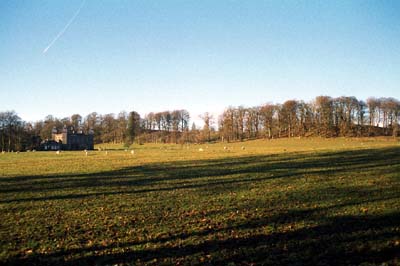
Dinefwr character area includes the whole of Dinefwr Park, plus small areas outside which were associated with the estate such as the Home Farm. The park lies on hilly ground on the northern side of the Tywi valley, immediately to the east of Llandeilo town, and achieves a height of over 90 m. Tree-covered slopes rise sharply from the valley floor to Dinefwr Castle which forms, along with Newton House, the two main foci of the park. The castle stands in a commanding position, overlooking long stretches of the valley. The masonry remains mostly belong to the 13th- and 14th-century, and to estate repairs of the 18th- and 19th- century. The castle is currently being conserved by Cadw. Earthworks outside the castle form part of the outer defence, but probably also mark the site of the small town of Dinefwr. Newton House, the main residence of the Dinefwr estate, provides the second focus in the park. Nothing now remains above ground of the Medieval town, Newton, on which the original mansion was built. The current house dates to the mid 17th-century, but had a new facade built in the 1850s in a Gothic style. The house and most of the parkland is owned by the National Trust. A fine collection of stone-built service buildings arranged around a courtyard lies close to Dinefwr House. Other elements of the gardens and park such as a walled garden, icehouse, dovecote and ponds survive. The 18th century park retains much of its planting. Individual trees, clumps, and more extensive stands of woodland survive. The open character of the park remains - especially the deer park on the western side - though wire fences divide the eastern part of it into large enclosures of pasture. The southeastern corner of the park - Penlan Park - has been municipalised and laid out with tarmac paths. The isolated and redundant Medieval church of Llandyfeisant lies in the area. Those field boundaries that surround the park are earth banks topped with hedges.
Recorded archaeology mainly relates to the parkland landscape and its features, including a rabbit warren, but underlying features include a possible Bronze Age ring ditch. Roman archaeology includes a milestone, possible roads and tracks and a coin hoard. Features relating to the Medieval settlement of Newton probably underlie present enclosures.
Dinefwr Park contains many distinctive buildings, and with the garden is listed as PGW (Dy) 12 (CAM) in the Cadw/ICOMOS Register of Parks and Gardens of Special Historic Interest in Wales (Whittle 1999). The Medieval Dinefwr Castle is a Scheduled Ancient Monument and a Grade I listed building. St Tyfi's Church, Llandyfeisant, heavily restored in the 19th century, is a Grade II listed building. Dinefwr (Newton) House, the summer house, and the inner and outer courtyard ranges are Grade II* listed while the ha-ha, fountain, dairy cottage, dovecote, deer abattoir, icehouse, home farmhouse, corn barn and byre/ stable range are individually Grade II listed (9 in all). A bandstand lies in Penlan Park.
Dinefwr park is a distinct character area and stands in sharp contrast with the surrounding farmland and with the urban setting of Llandeilo.