|

214 LLWYNHOWELL 
GRID REFERENCE: SN 758358 AREA IN HECTARES: 427.80
Historic Background
A small area to the north of the town of Llandovery, either side of the
River Tywi. Settlement in the area has considerable time-depth - at the
north end of the area is an Iron Age hillfort, and the line of a Roman
road leading northwards from the fort at Llandovery (Alabum) crosses the
valley floor. Henllys, to the south of the fort, may be the site of an
early Medieval administrative centre. By the historic period the Tywi
formed the boundary between Cantref Bychan to the east and Cantref Mawr
to the west. Cantref Bychan was invaded by the Anglo-Normans under Richard
Fitz Pons who established a caput at Llandovery in 1110-16 (Rees n.d.)
and was acquired soon after by the Clifford lords of Brecon as the Lordship
of Llandovery; the latter remained an independent Welsh lordship until
1284. Both retained native tenurial customs until the end of the Medieval
period when they were united within modern Carmarthenshire but Area 214
lay within the Medieval borough of Llandovery (Rees 1932) and was subject
to Anglo-Norman tenure, representing 'town lands'. The northern boundary
of the borough was apparently present in physical form as the 'Ditch of
Krenchy' (ibid.) which may now be represented by a stream, Nant Ogwrn.
The name 'Dolauhirion' suggests the former presence of strip-fields, which
may account for the linear field boundaries occurring throughout the area.
However, unlike Area 213 there is no physical evidence for the practice
of ridge-and-furrow agriculture. The present pattern of large, fairly
regular enclosures may have been a product of the 17th- or early 18th-century,
supplanting previous open-field systems. In the floodplain of the Tywi
itself are larger, more regular enclosures which may be of later, 18th
century date. The former enclosure may be associated with the gentry houses,
particularly Llwynhowell and Henllys which have origins before the 16th
century (Jones 1987, 94, 118-9), Manorafon whose estate is documented
from 1749 (Judith Alfrey, pers. comm.) and Tonn, which was mentioned in
1759 but burnt down in 1916 (Jones 1987, 181). The Tywi is crossed at
Dolauhirion via a bridge with Medieval origins and by a Medieval ford
at Llwynhowell, while the bridge carrying the A40(T) into Llandovery has
replaced a 19th century suspension bridge which itself succeeded a ferry.
The southern part of the area is crossed by the railway from Llandovery
to Llanwrtyd Wells, which had been established by 1871 as part of the
London and North Western Railway (LNWR) Central Wales and Carmarthen Junction
Line. It is still operational and forms part of the 'Heart of Wales' line.
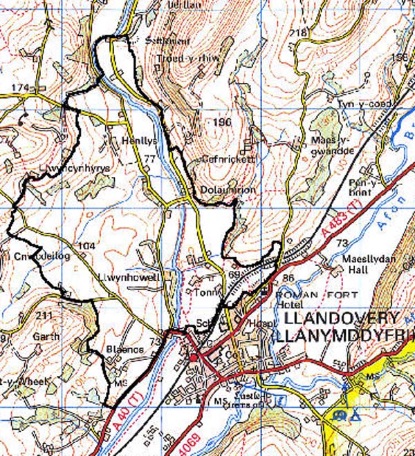
Base map reproduced from the OS map with the permission
of Ordnance Survey on behalf of The Controller of Her Majesty's Stationery
Office, © Crown Copyright 2001.
All rights reserved. Unauthorised reproduction infringes Crown Copyright
and may lead to prosecution or civil proceedings. Licence Number: GD272221
Description and essential historic landscape components
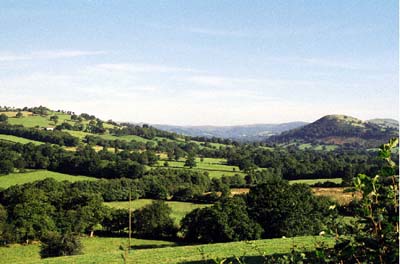
Llwynhowell character area lies across the valley floor of the Tywi immediately
upstream of Llandovery, and includes the gently-sloping west side and
lower slopes of the eastern side of the valley. The narrow floodplain
of the Tywi lies at approximately 70 m, and the western valley side rises
up to over 120 m. This is essentially a landscape of small- to medium-sized
irregular fields, large dispersed farms and scattered woodland. Improved
pasture dominates the agricultural land-use; there is little rough ground.
Field boundaries are composed of earth banks topped with hedges. Hedges
are generally well maintained at lower levels, but at higher altitudes
there is a tendency for them to be overgrown and derelict. Wire fences
supplement the hedges. Some hedges contain distinctive trees, and these
together with small stands of deciduous woodland - mostly on steeper valley
sides - lend a moderately wooded aspect to some parts of this area. There
are areas of former emparking but these have not profoundly influenced
the appearance of the landscape. Farms are distributed along the lower
valley sides on both sides of the Tywi. Farms are generally substantial.
Farmhouses are mostly 18th- or 19th-century in date, stone-built with
slate roofs and tend towards the polite, with semi-formal, stone-built
outbuildings, although most are also associated with modern agricultural
buildings. In addition to the farms there are many dispersed dwellings
across the area, but concentrated alongside roads close to Llandovery.
These are mainly of two periods: late 19th century 'villas', and late
20th-century houses and bungalows in a mixture of styles and materials.
This part of the upper Tywi valley is a route corridor, with a B road
following the generalised line of a Roman road on the eastern side of
the river.
Recorded archaeology is limited to the Roman road and Roman finds to the south, near the fort at Llanfair-ar-y-bryn, and to the site of Tonn Mansion.
There are a number of distinctive buildings. The Grade I listed Dolauhirion bridge is by William Edwards from 1773, built on the site of a Medieval bridge. Manorafon, with model farm buildings from c.1800 (Judith Alfrey, pers. comm.), represents an important early example of farm planning, and Henllys is a Grade II* listed double-pile house associated with 6 Grade II listed outbuildings. There are also rebuilt gentry houses at Llwynhowell and Tonn, the latter - like Henllys - with an area of possible former emparking. Farms have generally been constructed with some architectural consideration, rather than in the vernacular tradition. There are some late 19th-century brick and stone-and-brick farmhouses present. Stone-built outbuildings are equally substantial and in some instances are in a semi-formal arrangement with the house
This is a very difficult area to define as, apart from its southern side against the urban area of Llandovery, neighbouring areas contain similar historic landscape components. In these cases there is a zone of change, rather than a hard-edged border.