|

220 DINAS 
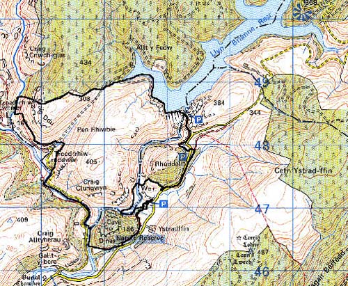
GRID REFERENCE: SN 780477 AREA IN HECTARES: 424.60
Historic Background
A small area in the foothills of the Cambrian Mountains, partly in Carmarthenshire
but mainly lying within the historic gwlad and modern county of Ceredigion,
which was consolidated under Anglo-Norman rule in 1110 when it was granted
to Gilbert de Clare. Throughout most of the 12th century, however, it
was under native rule (Rees, n.d.). The commote of Penardd, of Cantref
Uwch Aeron, within which the area lay, retained native tenurial customs
throughout the Medieval period. Area 220, in fact, lay within the Manor
of Llanddewi Brefi which was a possession of the Bishops of St Davids
from at least the Conquest until the end of the Medieval period (Rees
1932). It was an upland manor, probably operated by tenant farmers primarily
concerned with the mountain pasturing of animals, and appears to have
been largely unenclosed during the historic period, as it is today. It
is depicted much as at present on the earliest historic maps, and those
enclosures that exist relate to 19th century encroachment into former
open land. The area has no contemporary settlement, which largely reflects
its historic usage; however the name 'Dinas' possibly represents an Iron
Age hillfort for which there does not appear to be any physical evidence.
A cave, 'Ystafell Twm Sion Catti', is reputed to have been the base of
Twm Sion Catti, a picturesque and nomadic character of the 17th century.
Base map reproduced from the OS map with the permission
of Ordnance Survey on behalf of The Controller of Her Majesty's Stationery
Office, © Crown Copyright 2001.
All rights reserved. Unauthorised reproduction infringes Crown Copyright
and may lead to prosecution or civil proceedings. Licence Number: GD272221
Description and essential historic landscape components
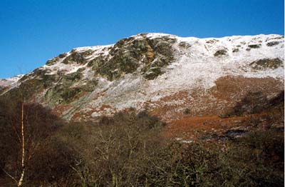
Dinas character area consists of a small block of moorland and woodland
in the upper Tywi valley ranging in height from 150 m to 400 m. The river
Tywi runs through this area, separating two hillocks from the main area.
These two hillocks are heavily cloaked in deciduous woodland and are part
of an RSPB reserve. The main area rises steeply in a series of craggy
and scree covered slopes from the Tywi. Apart from wire fences it is unenclosed,
and consists of very rough grazing with peaty deposits.
Recorded archaeology is confined to the possible hillfort, the possible place-name evidence 'Cae'r mot', and the cave 'Ystafell Twm Sion Catti'.
There are no standing buildings.
Dinas is a well defined area and contrast with the farmland of the valleys. It is bounded to the north by a conifer plantation and by Llyn Brianne.