|

257 LLANWRDA PARISH 
GRID REFERENCE: SN 727352 AREA IN HECTARES: 2058.00
Historic Background
An area lying on the north-west side of the Tywi Valley. During the historic
period it lay within the commote of Malláen, the late Medieval parish
of Llanwrda and the later hundred of Caeo (Rees 1932). The commote was
held of the independent Welsh lordship of Cantref Mawr until the establishment
of the county of Carmarthen in 1284, and in this area was subdivided into
Gwestfa Llanwrda, probably administered from a llys at Neuadd Llanwrda
(Area 210), and Gwestfa Ystrad Mynys, probably administered from a llys
at Ystrad (Area 208). There is evidence for settlement from an early period;
a possible Iron Age hillfort lies within the area while the Roman road
from Carmarthen to Llandovery, turnpiked in 1763-71 (Lewis, 1971, 43)
and now represented by the A40(T), partly forms its south-eastern edge.
The road was probably the route taken by the Anglo-Normans advancing from
the east under Richard Fitz Pons who established a caput at Llandovery
in 1110-16 (Rees n.d.) and subdued Cantref Bychan to the south. This initial
campaign may be the context for the establishment of the motte at Glan-Mynys,
on the edge of the Tywi floodplain; it may, however, be an independent
Welsh foundation lying as it does in association with the possible llys
at Ystrad. There may be a Medieval settlement site at Cwmdwr in the west
of the area, and a possible moated site lies just beyond the northern
edge. The present system of medium-large irregular fields suggests enclosure
by the earlier Post-Medieval period, by which time the present pattern
of farms had probably developed. The landscape is more-or-less unchanged
from that depicted on the Llanwrda tithe map of 1837. There are no villages
within the area but there is an interesting late development at Siloh
where an early 19th century chapel and public house, on the droving route
from Caeo to Llandovery which crosses the northern part of the area, became
the focii for a small nucleation. There has been little recent development.
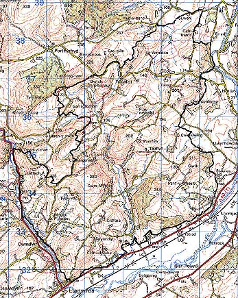
Base map reproduced from the OS map with the permission
of Ordnance Survey on behalf of The Controller of Her Majesty's Stationery
Office, © Crown Copyright 2001.
All rights reserved. Unauthorised reproduction infringes Crown Copyright
and may lead to prosecution or civil proceedings. Licence Number: GD272221
Description and essential historic landscape components
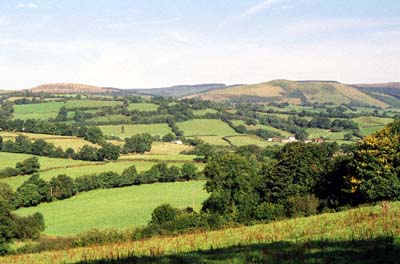
This very large character area lies on the northern side of the Tywi
valley and includes much of the parish of Llanwrda. From the floodplain
of the Tywi at approximately 60m the land rises steeply to over 130 m.
To the north of this the area is characterised by rolling hills and small,
steep-sided valleys lying between 100 m and 230 m. It is essentially a
landscape of widely dispersed farms, small irregular fields and scattered
woodland. Boundaries to the fields consist of earth banks topped with
hedges. Over such a wide area there are differences in the management
of hedgerows, but most are in good condition, though there is a tendency
for them to become derelict at higher levels, and overgrown at lower levels.
Many of the hedges have distinctive hedgerow trees, and these together
with the numerous small stands of deciduous woodland (particularly distinctive
on the steep valley sides) and medium-sized conifer plantations lend a
wooded aspect to the landscape. Farmland land-use is almost entirely improved
pasture, with very little rough grazing and rushy ground. There is no
aggregate settlement; the settlement pattern is dominated by dispersed
farms. Farmsteads are generally 19th century, stone-built, two-store and
three-bay. Clearly over such a large area there is variation in type,
but most are in the vernacular tradition, with fewer examples in the more
polite 'Georgian' style. Older farm buildings are stone-built. There is
a considerable variation in size and layout of these buildings, but mostly
they are limited to one or two ranges, but with some larger more complex
examples arranged formally around a yard. Most farms have modern agricultural
buildings. There is virtually no modern residential development. Apart
from a B road which cuts across the northern part of this area and which
replaces the route of a Roman road from Llandovery to Pumsaint a little
way to the north, all transport links in this area are local and consist
of lanes, tracks and paths.
Recorded archaeology comprises a possible Iron Age hillfort, a Medieval settlement site, motte and possible chapel site, and a possible signal station of unknown date.
There are few distinctive buildings including Siloh and Tabor chapels, a former public house, dwellings, bridges and former mills.
To the north and west character areas have yet to be described, but here land rises into a series of low unenclosed and semi-enclosed hills. On other sides neighbouring character areas have similar landscape components to this area; here there is a zone of change rather than a hard-edged boundary.