Home > Historic Landscapes > Black Mountain and Mynydd Myddfai > |

238 GLASFYNYDD FOREST - USK RESERVOIR

GRID REFERENCE: SN 823279
AREA IN HECTARES: 834.00
Historic Background
A character area lying at the summit of Mynydd Myddfai, around the Usk
Reservoir. The northern half of the area occupied the former Maenor Myddfai,
Cwmwd Perfedd, of Cantref Bychan which retained native tenurial customs
until the end of the Medieval period when it was incorporated within modern
Carmarthenshire. During the Post-Medieval period was held by the Vaughans
of Golden Grove and the Earls of Cawdor (James n.d., 87). The southern
half of the area lay within the Lordship of Brycheiniog. The area is typical
of upland southwest Wales in its high preservation of prehistoric archaeology,
which provide great time-depth and is here represented by a Bronze Age
funerary/ritual landscape including standing stones and round barrows.
During the historic period much of the area was operated as a grange,
Dôl Hywel, which had been granted to Talley Abbey by 1324 (Ludlow 1998).
The grange chapel, dedicated to St David, was also a chapel-of-ease to
Myddfai parish (ibid.), but its site appears to lie beneath the Usk Reservoir.
It was an upland grange, probably operated by tenant farmers primarily
concerned with the mountain pasturing of animals, and appears to have
been largely unenclosed during the historic period, as it still is today.
The earliest historic maps depict it as open moorland with few settlements.
Some fields are shown on the lower valley sides, however, and physical
evidence for former enclosure exists, including relict trackways and drainage
systems from the early Post-Medieval period, found in association with
the cottage and longhut settlements characteristic of the uplands of southwest
Wales during the transitional and Post-Medieval periods (Sambrook and
Ramsey, 1999). Some of this settlement may be associated with the tilestone
quarries in neighbouring Area 240. The area has no recent settlement,
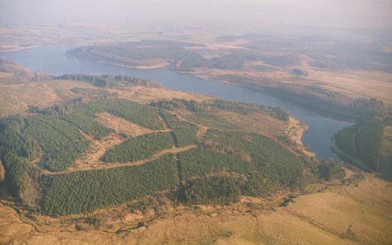
but the Usk Reservoir, opened as a water supply for Swansea in 1955, has
had a profound effect on the landscape, as has the extensive conifer plantation
which occupies the rest of the area.
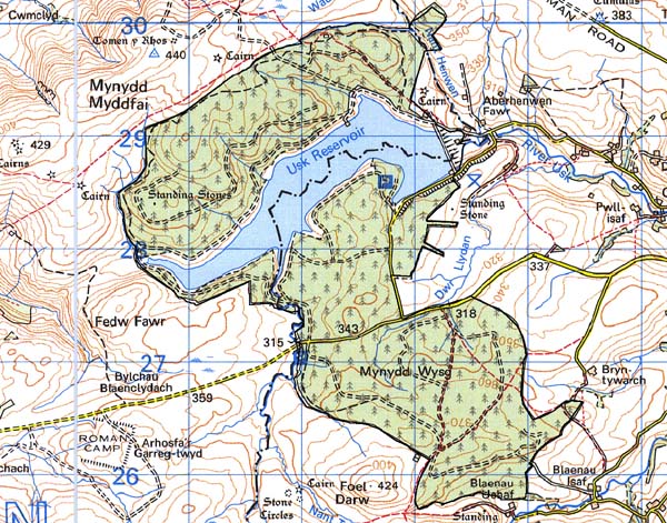
Base map reproduced from the OS map with
the permission of Ordnance Survey on behalf of The Controller of Her Majesty's
Stationery Office, © Crown Copyright 2001.
All rights reserved. Unauthorised reproduction infringes
Crown Copyright and may lead to prosecution or civil proceedings. Licence
Number: GD272221
Description and essential historic
landscape components
This character area comprises mostly 20th century elements. The land lies
in the upper Usk valley at heights of between 300 m and 400 m. The whole
area is now either beneath the waters of the Usk reservoir, or beneath
dense conifer plantation. Prior to the construction of the reservoir and
the planting of trees most of the area was open moorland - the Black Mountain/Mynydd
Myddfai - although there was a little enclosed land and abandoned settlement
on the lower valley sides and valley bottom.
Recorded archaeology is rich and diverse, comprising a Neolithic findspot, two Bronze Age standing stones and a stone pair, two Bronze Age round barrows, the Medieval grange and chapel site, and Post-Medieval settlement features including a longhut, cottages, a farmstead, a trackway and a drainage system.
All surviving buildings are derelict and are simple, dry-stone built cottages.
This area is very well defined as it is bordered by open moorland to the west and north, and by enclosed land in Powys to the east and south.