|

260 FOEL DYRCH 
GRID REFERENCE: SN157301
AREA IN HECTARES: 132.1
Historic Background
A small compact character area in modern Pembrokeshire comprising
the isolated hill Foel Dyrch, on the southeast flank of Mynydd Preseli.
It lay within the medieval Cantref Cemaes which was brought under Anglo-Norman
control by the Fitzmartins in c.1100. The Fitzmartins retained it, as
the Barony of Cemaes, until 1326 when they were succeeded by the Audleys.
The Barony was conterminous with the later Hundred of Cemais, which was
created in 1536, but many feudal rights and obligations persisted, some
until as late as 1922. Like most of the southeastern part of the Barony
within Mynydd Preseli, the Foel Dyrch area continued to be held under
Welsh systems of tenure. In 1118, William Fitzmartin granted this area,
as part of the grange of Nigra Grangia, to the Tironians of St Dogmaels
Abbey. Its assessment at only half a knight's fee suggests that the grange
was probably mainly unenclosed moorland pasture during the medieval period.
At the Dissolution, it was acquired by John Bradshaw of Presteigne, along
with St Dogmaels Abbey, and was thereafter held distinct from the Barony
of Cemaes. Foel Dyrch was part of unenclosed moorland, held of the Barony
with common rights to pasture and turbary, and is still unenclosed. It
has been subject to other use; the slate quarry of Upper Tyrch on the
southern edge of the area - from which County Hall, Carmarthen was roofed
- was operational from the late 18th-century until 1939, and two further
small quarry site lie on the flanks of the area. During world war two,
Upper Tyrch quarry was apparently used by American Forces as a practice
gun emplacement.

Base map reproduced from the OS map with the permission
of Ordnance Survey on behalf of The Controller of Her Majesty's Stationery
Office, © Crown Copyright 2001.
All rights reserved. Unauthorised reproduction infringes Crown Copyright
and may lead to prosecution or civil proceedings. Licence Number: GD272221
Description and essential historic landscape components
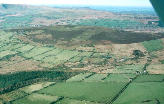
Foel Dyrch is a distinctive outlying rounded hill on the southeastern
side of Mynydd Preseli that rises from the surrounding enclosed farmland
at about 250m to achieve a maximum height of 368m. It is unenclosed. Rough
grazing - heather and bracken - constitutes the main land-use. Abandoned
pits and spoil heaps of Upper Tyrch and other smaller quarries are a distinctive
element of the historic landscape. There are no extant settlements. However,
small clumps of trees stand on and around abandoned farms and cottages
on the eastern flank of the hill. Apart from these, this is a treeless
landscape. There are no roads or tracks.
Recorded archaeology is limited to a possible standing stone, and a possible round barrow at the summit of Foel Dyrch, both from the bronze age. In addition there is a post-medieval sheepfold, Upper Tyrch slate quarry and two other minor workings, and military features from world war two.
There are no standing buildings.
Foel Dyrch is a discrete historic landscape character area, with a hard-edged boundary to the north, west and south against the enclosed land of Mynachlog-ddu. To the east boundary definition is less good against the semi-open land of Crugiau Dwy.
Sources: Dyfed Archaeological Trust 1997; Lewis 1969; Monachlogddu tithe map and apportionment 1846; Rees 1932; Richards 1998 .