|

267 RHOSFACH 
GRID REFERENCE: SN104280
AREA IN HECTARES: 312.3
Historic Background
A small area of modern Pembrokeshire, on the southern edge of Mynydd
Preseli, within the medieval Cantref Cemaes. Cemaes was brought under
Anglo-Norman control by the Fitzmartins in c.1100. The Fitzmartins retained
it, as the Barony of Cemaes, until 1326 when they were succeeded by the
Audleys. The Barony was conterminous with the later Hundred of Cemais,
which was created in 1536, but many feudal rights and obligations persisted,
some until as late as 1922. The Rhosfach character area belonged to the
mesne lordship or manor of Maenclochog, held from the Barony of Cemaes
by the Roche lords of Llangwm in the 13th- and 14th-century, when it was
assessed at one knight's fee. In 1594, Maenclochog was - like other Cemaes
manors - held on an annual lease from the Barony, this one being assessed
in an Extent at 3s 8d. However, like most of the southeastern part of
the Barony, within Mynydd Preseli, this area continued to be held under
Welsh systems of tenure. The character area is now enclosed but during
the medieval period, the entire area was probably unenclosed moorland
pasture. In 1301, David de la Roche granted to the monks of Whitland Abbey
grazing rights for horses 'on Preseli and the waste places thereabouts
for seven years, at one penny and thereafter 2 shillings'. Some of this
land may have occupied the Rhosfach area, which includes four detached
areas of common. These are surviving remnants of a larger area of common
of which the County History records the rights of turbary claimed in 1724.
A Hafod farm-name also lies towards the west. Pen-gawsai and Meini-hirion
farmsteads, which lie within a system of small enclosures at the area's
southern limits were recorded in the 16th century. The remainder of this
character area probably remained largely unenclosed until a late date.
The majority of enclosures are large, with straight boundaries, while
most farm-names are not recorded before the 18th century, confirmed by
the biblical derivation of some eg. 'Pisgah' and 'Pen-Nebo'. The tithe
maps, from the 1840s, show strip-like fields in some locations, suggesting
that at least part of this area had evolved out of a sub-divided system
of lleini, and today some of the enclosures are still long and narrow.
This character area appears then to be a mixture of old established farms,
possibly with some squatter settlement, and large tracts of common land
which were settled and enclosed during the later 18th-century. The commons
are now named after the settlements at Llangolman, Llandeilo Llwydarth,
Maenclochog and Rhosfach, but this does not reflect the distribution of
earlier grazing rights. The inter-relationship between the enclosed land
and these pockets of remaining common is shown very clearly on the Tymawr
estate map from 1777, which otherwise shows a pattern similar to today.
Three named slate quarries lie at the western end of the area, all fairly
small-scale - and short-lived - operations of the late 19th- and early
20th-century, and an unnamed working lies at the centre
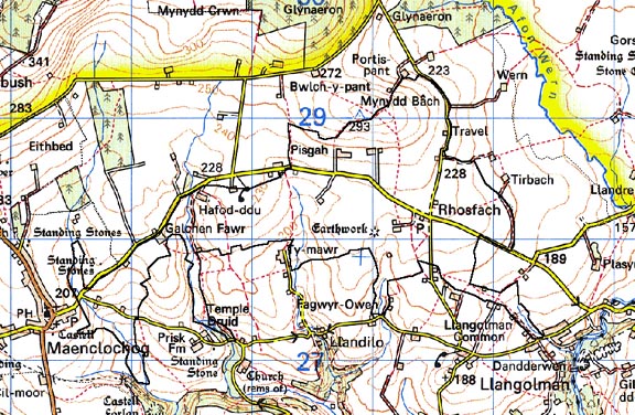
Base map reproduced from the OS map with the permission
of Ordnance Survey on behalf of The Controller of Her Majesty's Stationery
Office, © Crown Copyright 2001.
All rights reserved. Unauthorised reproduction infringes Crown Copyright
and may lead to prosecution or civil proceedings. Licence Number: GD272221
Description and essential historic landscape components
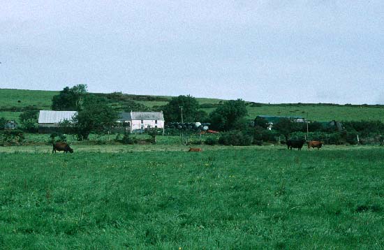
Rhosfach historic landscape character area lies on the southern, gentle
south-facing slopes of Mynydd Preseli at between 270m and 200m. Most of
the area is enclosed farmland, but there are pockets of unenclosed common
- Llangolman Common, Llandeilo Common, Maenclochog Common and Rhosfach
Common. The enclosure pattern is one of small irregular fields, but there
are some long strip-shaped fields in the eastern part of the area. Boundaries
mostly comprise stone and earth banks topped with hedges. Apart from those
that flank roads and tracks the hedges are in a very poor condition -
either entirely gone or represented by straggling lines of bushes and
small trees. Wire fences on the banks provide stock-proof boundaries.
Land-use is a mixture of improved pasture, unimproved pasture and rough
grazing with rushes, gorse and scrubby woodland on the commons. Apart
from the small trees in the overgrown hedges and the scrubby woodland,
woodland is not a characteristic element of the historic landscape. The
settlement pattern is one of dispersed farms and cottages. Dwellings are
predominantly 19th century, in the vernacular style, stone-built (cement
rendered and/or bare stone), three bays, one, one-and-a-half and two storeys,
with slate roofs. It is likely that the cement rendering on some of these
dwellings masks earth (clom) construction. The single storey cottages
are a distinctive element of this landscape. There are a few late 20th-century
houses in a variety of styles and materials. Generally agricultural buildings
are small, reflecting the size of the holdings. They include single small,
stone-built 19th century ranges; mid 20th-century corrugated-iron barns
and other structures; and small late 20th-century steel-, concrete- and
asbestos-built structures. There are no listed buildings in this area.
Transport routes consist of narrow winding lanes and tracks flanked by
high hedge-banks.
Recorded archaeology is fairly diverse and includes a possible neolithic chambered tomb, a bronze age cremation, a scheduled round barrow and two possible further barrows, and one definite and three possible standing stones. There is a scheduled iron age hillfort (or medieval motte), and a further possible hillfort. From the medieval period is a mill site, and from the post-medieval period four quarries including Mill, Galchen and Vagur quarries, and a world war two military camp near Maenclochog.
This distinctive historic landscape character area has well delineated boundaries. It is bordered to the north, east and west by an area of Parliamentary enclosure - Mynydd Bach - and to the south by the larger farms and enclosures of Llangolman
Sources: Charles 1992; Howells 1977; Howells, 1987; Hunter, 1852; Llandeilo Llwydarth tithe map and apportionment, 1841; Llangolman tithe map and apportionment, 1841; Pembrokeshire Record Office D/EE/7/338; Rees 1932; Richards 1998