|

274 GELLIFAWR 
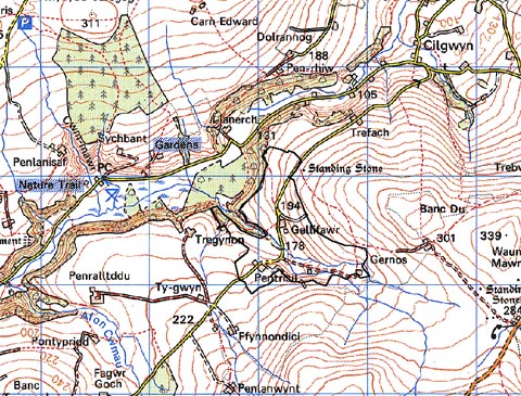
GRID REFERENCE: SN062345
AREA IN HECTARES: 80.2
Historic Background
A small area of modern Pembrokeshire, on the western flanks of Mynydd
Preseli, more-or-less surrounded by Tregynon character area. It lies within
the medieval Cantref Cemaes which was brought under Anglo-Norman control
in c.1100 by the Fitzmartins. They retained it, as the Barony of Cemaes,
until 1326, when they were succeeded by the Audleys. The Barony was conterminous
with the later Hundred of Cemais, which was created in 1536, but many
feudal rights and obligations persisted, some until as late as 1922. The
Gellifawr character area lies mainly within the hamlet of Cilgwyn, Nevern
parish, which was a borough of the barony during the medieval period.
The Extent of Cemaes, compiled in 1577, suggests that many of the holdings
within the present character area had already been established. Clyn and
Pentrisil - which were 'parcel of Tregynon' in Tregynon character area
- paid 3d each annually to the Barony of Cemaes. The holdings may date
from the 16th century; the pattern of irregular fields is typical the
period of land that was enclosed from open, rough pasture. It still has
a moorland quality towards the east of the area, although there is clear
evidence of cultivation ridges at Gernos-fawr. The equation on the Rees
map of Gellifawr with the 'Pencellifawr' recorded in the Extent appears
to be a mistake for Pencelli in Eglwysrwrw parish. However, an important
farmhouse has stood at Gellifawr since the early 18th-century, under five
generations of the James family. The tithe map of 1843 shows a situation
like that of the present day. Land-use is still predominantly pastoral.
Base map reproduced from the OS map with the permission
of Ordnance Survey on behalf of The Controller of Her Majesty's Stationery
Office, © Crown Copyright 2001.
All rights reserved. Unauthorised reproduction infringes Crown Copyright
and may lead to prosecution or civil proceedings. Licence Number: GD272221
Description and essential historic landscape components
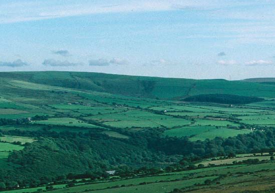
Gellifawr is a small historic landscape character area occupying the floor
and sides of a small valley on the northwestern flanks of Mynydd Preseli.
The valley floor of the northwest-flowing stream lies between 180m and
240m. This area is characterised by small, irregular fields clustered
around several farms located on the flanks of the valley. Boundaries are
a mixture of stone-faced banks and stone and earth banks. Banks are topped
with hedges. Hedges are mostly overgrown and these together with scrubby
woodland in the valley bottom lend a wooded aspect to the area. Agricultural
land-use is predominantly improved pasture and a little arable, but with
rougher grazing and peaty ground in the valley bottoms. The settlement
pattern is of dispersed farms. The largest of these, Gellifawr, is a substantial
mid 19th-century house in the polite Georgian style, but with earlier
elements, built of local dolerite and with several very large outbuildings
set in a semi formal arrangement to the house and built of the same stone
and of the same date as the house. These have been converted for tourist
use. Other farmhouses are 19th century and typically of two storey, three
bay, stone-built and cement rendered, and in the vernacular tradition.
Farm buildings of the smaller farms are relatively small and of a variety
of styles and dates, though Pentrisil has a very large assemblage of late
20th-century structures. There are no listed buildings within the character
area.Transport links in this area are limited to local-use narrow winding
lanes and tracks.
Recorded archaeology is limited to the settlement sites of Gellifawr and Gernos-fawr, and a possible bronze age standing stone site.
Although this is a distinct historic landscape character area, the boundary between it and the area it borders on three sides, Tregynon, is not well marked - there is a zone of change rather than a hard-edged definition.
Sources: Charles 1992; Howells 1977; Jones 1996; Nevern tithe map and apportionment, 1843; Rees 1932; Sambrook 1997.