|

278 CARNEDD MEIBION-OWEN 
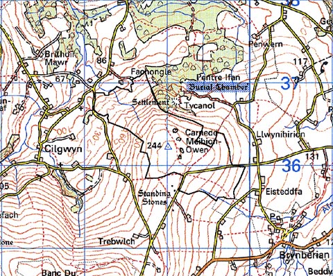
GRID REFERENCE: SN090365
AREA IN HECTARES: 114.4
Historic Background
A small area of modern Pembrokeshire, on the very northern edge of Mynydd
Preseli, within the medieval Cantref Cemaes. Cemaes was brought under
Anglo-Norman control in c.1100 by the Fitzmartins who retained it, as
the Barony of Cemaes, until 1326, when they were succeeded by the Audleys.
The Barony was conterminous with the later Hundred of Cemais, which was
created in 1536, but many feudal rights and obligations persisted, some
until as late as 1922. This character area lies within Nevern parish,
which was a borough of the barony during the medieval period. It is now
rocky, barren moorland with little enclosure, but its lower slopes at
least may have formerly been wooded. The medieval Cilruth Wood - of which
Pentre Ifan Wood is a remnant - had been under the forest jurisdiction
of the Barony since the 12th century when it was said to extend up the
slopes of Carnedd Meibion Owen, and is marked as 'Forest' on the Rees
map. The area was cleared prior to attempts to enclose it with a system
of large irregular fields. These have a late appearance, and the deserted
settlement that has recently been recorded here probably represents a
squatter settlement from the population-pressure years of the 18th century.
There are now no settlements, reflecting the situation recorded on the
tithe map of 1843, and much of the northwest part of this area is reverting
to woodland.
Base map reproduced from the OS map with the permission
of Ordnance Survey on behalf of The Controller of Her Majesty's Stationery
Office, © Crown Copyright 2001.
All rights reserved. Unauthorised reproduction infringes Crown Copyright
and may lead to prosecution or civil proceedings. Licence Number: GD272221
Description and essential historic landscape components
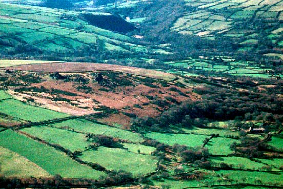
Carnedd Meibion-Owen historic landscape character area is a craggy out-lying
hill surrounded by enclosed farmland. Towards the summit of the hill,
at 244m, the several eponymous rocky tor-like outcrops lie in open bracken,
gorse and heather moorland. To the north, west and south this moorland
runs down to below 150m. On the western side there are some redundant
hedge-banks. Woodland is beginning to recolonise the lower, northwestern
slopes. Surrounding the moorland, and also providing some subdivision
on the southern side are large stone-faced banks. There are no hedges.
The eastern end of the summit down to approximately 180m has been recently
improved into pasture with a little arable and divided by wire fences.
There are no buildings in this area. Transport elements of the landscape
only comprise lanes and tracks.
Recorded archaeology comprises two possible neolithic chambered tombs ('Carnedd Meibion Owen'), a trackway of unknown date, a medieval holy well and the post-medieval settlement site.
The open moorland element of Carnedd Meibion-Owen historic landscape character area is distinctive and well defined. Recent improvements to the eastern end of the area have, however, made distinctions between it and the surrounding enclosed farmland less clear. Here there is no longer a clear boundary between it and its neighbours.
Sources: Nevern tithe map and apportionment, 1843; Rees 1932; Trethowan 1998.