|

282 HAFOD TYDFIL 
GRID REFERENCE: SN116337
AREA IN HECTARES: 11.5
Historic Background
A very small character area near the summit of Mynydd Preseli. It comprises
a small pocket of enclosed land - 13 small fields - around a farmstead,
Hafod Tydfil. It lies within the unenclosed land of Mynydd Preseli common
on which the freeholders of Cemaes had been granted rights of pasture
and turbary by a charter of Nicholas Fitzmartin in the late13th-century.
Superficially, the enclosure appears later post-medieval, but 'Hafod Tidvill'
is mentioned in a document of 1585-6 as a 'tenement of 8 acres', under
the ownership of the Bowens of Pentre Ifan. It appears to have been one
of several areas of former enclosure within the common, the evidence of
which can be seen elsewhere as weathered bank systems, sometimes associated
with deserted rural settlement sites on the moorland. Hafod Tydfil was
assessed for 2 hearths in 1670, and had assumed its present form by at
least the time of the tithe survey, in 1841. It continued to be occupied
until the 1950s.
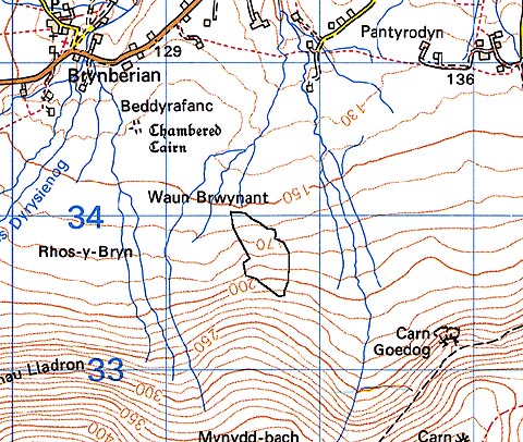
Base map reproduced from the OS map with the permission
of Ordnance Survey on behalf of The Controller of Her Majesty's Stationery
Office, © Crown Copyright 2001.
All rights reserved. Unauthorised reproduction infringes Crown Copyright
and may lead to prosecution or civil proceedings. Licence Number: GD272221
Description and essential historic landscape components
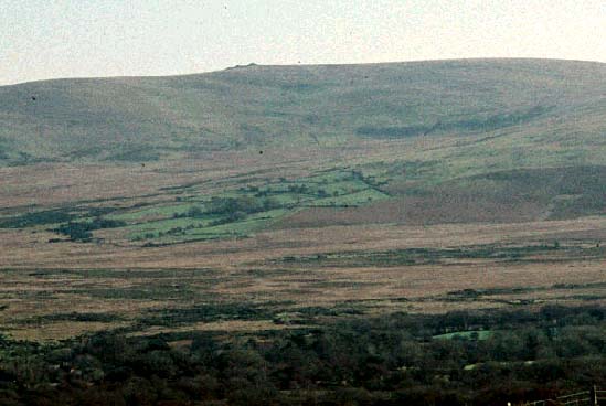
Hafod Tydfil historic landscape character area consists of several fields
surrounded by the open moorland of Mynydd Preseli. It lies on north-facing
slopes between 150m and 220m. The fields are small and irregular, and
are divided by banks of earth and stone. Hedges that top the banks are
overgrown and contain numerous small trees. Land-use is improved pasture.
The dwelling and other buildings of the farmstead have been demolished.
No other archaeology has been recorded in this character area.
This is a very distinct historic landscape character area; its fields and hedges form an island of green in the surrounding open moorland.
Sources: Charles 1992; Jones 1996; Meline tithe map and apportionment, 1841 .