|

287 TYWYN 
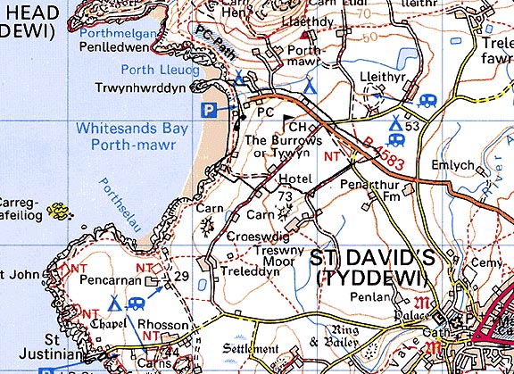
GRID REFERENCE: SM738268
AREA IN HECTARES: 66.8
Historic Background
A small area of modern Pembrokeshire, just south of St David's Head, conterminous
with an area of blown sand, 'The Burrows', which developed during the
historic period and now lies under grass. The area lay within the medieval
Cantref Pebidiog, or 'Dewisland', which was held directly by the Bishops
of St David's, having represented the core of the bishopric from 1082
when it was granted (or confirmed) by Rhys ap Tewdwr, king of pre-Conquest
Dyfed, to Bishop Sulien. The character area lies within the large parish
of St David's, which had a number of subordinate chapels, and even today
preserves a remarkable ecclesiastical topography. In the Tywyn character
area some of the ecclesiastical element may be early. The antiquarian
Richard Fenton made dubious claims that a building - the original church
of St David's - lay beneath the sand burrows, as well as his entirely
spurious Roman 'station' of Menapia. However, the place-name 'the old
church' has been recorded towards the east of the area, possibly referring
to a later chapelry, and the chapel dedicated to St Patrick at Porthmawr
bay, which lies at a potential embarkation point for early medieval pilgrims,
has produced medieval cist burials. The character area appears to have
been free of sand during the post Anglo-Norman conquest medieval period
when 2 bovates of land at Trewilym, worth annually 20d, were recorded
in the Black Book of St David's, of 1326, as belonging to the manor of
Welsh Hundred. This arable land now lies beneath the sand burrows, which
had formed by c.1800 when they were described by Fenton, and by which
time they supported unenclosed pasture. This is shown as common land without
settlements on the tithe map of 1840 extending slightly eastwards of the
present limit. It was subject to Parliamentary enclosure in 1869, but
this seems to have had little effect on the landscape, with few new fields
and no new settlements. Enormous quantities of sand were removed during
world war two for the construction of St David's and Brawdy airfields.
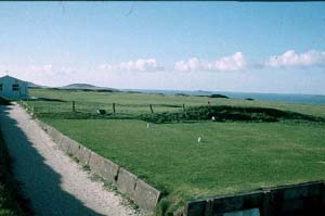
Recent development is limited to a golf course a hotel and dispersed housing.
Base map reproduced from the OS map with the permission
of Ordnance Survey on behalf of The Controller of Her Majesty's Stationery
Office, © Crown Copyright 2001.
All rights reserved. Unauthorised reproduction infringes Crown Copyright
and may lead to prosecution or civil proceedings. Licence Number: GD272221
Description and essential historic landscape components
Whitesands Bay forms the western boundary of Tywyn historic landscape
character area. From the beach the land rises rapidly to the east to approximately
25m, then more gently to a maximum of almost 60m. Almost the entire area
is covered with wind-blown sand, forming a dune system along the coast
with stable pasture over sand inland. Though subject to Parliamentary
enclosure in the 19th century, the historic character of this area did
not change much over the centuries, until the mid 20th-century, when a
golf course and club house were established, and a hotel and several dwellings
constructed. In addition, a large tarmac-surfaced car park with toilets,
cafe and other facilities is located at Whitesands Bay to serve the large
number of tourists who visit this part of the coast. The Pembrokeshire
Coast Path runs along the western fringe of the area. Adjacent to the
car park, protected by coastal defences, the remains of the medieval chapel
of St Patrick lie beneath a grassy mound. Buildings are mostly of concrete
and brick construction. Land-use consists of wind-blown sand close the
coast, the golf course, and unimproved pasture at the southern limits
of the area. Despite the 20th century buildings and the golf course, this
area retains an unenclosed aspect, although a 'Pembrokeshire' hedgebank
has recently been constructed across part of dune system. There are no
listed buildings in the area.
Recorded archaeology comprises a submerged forest and mesolithic finds on the foreshore, where four further prehistoric findspots include three from the bronze age. There is a possible neolithic chambered tomb. The scheduled St Patrick's Chapel is associated with cist burials and may have early medieval origins. There is no field evidence for Menapia, while the place-name 'the old church' and the medieval settlement of Trewilym lie beneath the sand burrows. There is also a post-medieval quarry.
The open aspect and wind blown sand of this area distinguish it from the neighbouring historic landscape character areas of dispersed farms and fields.
Sources: Charles 1992; Fenton 1811; Howell 1993; Howells 1987; James 1981; James 1993; Jones and Freeman 1856; Lewis 1833; Manby 1801; Pembrokeshire Record Office QRE/10; Rees 1932; St David's tithe map and apportionment 1840; Willis-Bund 1902