|

288 TRELEDDYD - TRETIO - CAERFARCHELL 
GRID REFERENCE: SM763280
AREA IN HECTARES: 1911
Historic Background
A large area of modern Pembrokeshire located on St David's Peninsula,
of great historic landscape interest. It lay within the medieval Cantref
Pebidiog, or 'Dewisland', which was held directly by the Bishops of St
David's, having represented the core of the bishopric from 1082 when it
was granted (or confirmed) by Rhys ap Tewdwr, king of pre-Conquest Dyfed,
to Bishop Sulien. The character area lies mainly within the parish of
St David's, which had a number of subordinate chapels, and even today
preserves a remarkable ecclesiastical topography. The area is crossed
by the Ffos-y-mynach ('monks' ditch'), an earthwork traditionally held
to be an early medieval boundary which may be rooted in fact as it does
not respect St David's parish boundary and may represent an earlier division.
A strong pre Anglo-Norman conquest ecclesiastical tradition is confirmed
by the archaeology of the area, with three concentrations of Early Christian
Monuments and three dark age cist cemetery sites. In addition, there are
a number of llan place-name elements perhaps representing lost chapels,
many of which may be later medieval in origin, as devotional rather than
formal chapels-of-ease. However, many of these have the place-name element
'old' and may have early medieval origins. From 1115, when Bernard, was
appointed Bishop of St David's, Anglo-Norman systems of feudal government
and ecclesiastical administration were introduced into Pebidiog, which
was conterminous with the later Hundred of Dewsland created in 1536. A
small part of the area to the east lies within Llanhywel parish, a medieval
division of Pebidiog, which was retained by the crown until 1302 when
the benefice was appropriated to St David's Cathedral. Whitchurch, also
in the east, did not become a parish until the post-medieval period, originally
being a chapelry of St David's parish. The major part of the character
area was divided between the 'manors' of Welsh Hundred and Tydwaldy. However,
Welsh tenurial systems appear to have persisted, though variously adapted,
and many feudal rights and obligations continued even into the early 20th-century.
Pebidiog was renowned for its fertile arable land. According to the census
in George Owen's Taylors Cussion, it was one of the most densely populated
regions of Pembrokeshire in the 16th century, with the most plough teams,
and was particularly productive of barley. There were proportionately
very few dairies. The Black Book of St David's of 1326 gives some idea
of the population density at an earlier period, listing within Welsh Hundred,
among others, the vills Carnhedryn, Lleithyr, Treleddyd, Trelewyd, Treleidr,
Tremynydd, Treliwyd, and Penarthur, and in Tydwaldy, the vills Penbery,
Tre-hysbys, Treiago, Tremynydd (again), and Tretio. All were semi-manorial,
held by a version of Welsh custom in which an infield-outfield system
was practised, where land was held not by individual ownership, but by
two persons and their co-owners. In fact 'gavelkind' had only recently
been abolished in Pebidiog when Owen wrote in c.1600, that the land was
still unenclosed 'and exposed to tempests'. Eighteenth- and early 19th-century
maps also show much of the land as still unenclosed. This tenure has given
rise to the dominant settlement pattern of the area, represented by a
high density of small hamlets, mainly with Tre- place-names and largely
based on the medieval vills. Tretio, Treleidr and Treleddyd are among
the hamlets shown as small nucleated settlements on estate maps of the
late 18th-century, some of which are shown surrounded by a sub-divided
field system, the best examples being at Treleddyd and Gwrhyd-Mawr. The
sub-divisions or strips in these systems are not the long, narrow curving
strips typical of an 'English' open field system, but rather rectangular
'shares' scattered across a wide area; a survival from Welsh tenure. Each
hamlet or township had its own system but most hamlets - and presumably
the medieval 'vills' - were associated with two small separate areas of
common land, one called 'common' and one called Waun or 'moor', the latter
being waste-land. Each hamlet is now occupied by a group of post-medieval
farm buildings. These sometimes include a chapel which, though normally
of late 18th- or 19th-century date and from a variety of denominations,
appears in some instances to occupy an earlier religious site, for example
at Carnhedryn there is a nearby Early Christian Monument, Caerfarchell
has a nearby cemetery site and Llandidgige has a documented medieval chapel.
This tenurial system was at its very end by the late 18th-century. A map
of Treleddyd from 1786 shows dispersed, unenclosed strips, but by 1821
this pattern had been enclosed and many of the strips transformed into
rectangular-shaped fields. In other examples the St David's tithe map
shows a pattern in which former strips are detectable in the overall pattern
of enclosed, rectangular and irregular-shaped fields. Large holdings,
such as Pwllcaerog, are the sites of former hamlets which gradually transformed
into single or paired farms. Paired farms are a feature of this landscape.
Smaller isolated farms, like Penlan, appear to be quite late, and were
probably established on the former open fields of the hamlets or of St
David's in the 16th- and 17th-century, while the nucleated settlement
at Whitchurch seems to be entirely modern. In addition, there is a Deserted
Rural Settlement site near Hendre, which like most of its contemporaries,
represents an 18th century squatter settlement on the fringes of Dowrog
Common. The economy of the area has remained overwhelmingly agricultural,
characterised since the mid 20th-century by early potato-growing, but
many quarries were established along the coast during the post-medieval
period, as well as at least one limekiln.
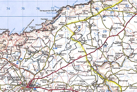
Base map reproduced from the OS map with the permission
of Ordnance Survey on behalf of The Controller of Her Majesty's Stationery
Office, © Crown Copyright 2001.
All rights reserved. Unauthorised reproduction infringes Crown Copyright
and may lead to prosecution or civil proceedings. Licence Number: GD272221
Description and essential historic landscape components
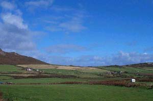
This is a large and complex historic landscape character area encompassing
most of the northern part of St David's Peninsula. The land is generally
level or gently sloping, with most slopes south-facing, located on average
between 50m and 80m. Part of the northern area includes high sea cliffs,
along the top of which runs the Pembrokeshire Coast Path. It is an agricultural
landscape, and the whole area is divided into small- to medium-sized fields.
Fields come in a variety of shapes, and though most are irregular or tending
to the rectangular, there are small sub-systems of short strip-shaped
fields, such as those close to Treleidr, Treleddyd and Gwrhyd-Mawr, that
have clearly evolved from an open, sub-divided field system. Across such
an extensive tract of landscape there is clearly variety in the field
boundaries, but most consist of earth or earth and stone banks, with some
rubble banks and dry-stone walls present. Hedges where present are low
and windswept, and often reduced to straggling lines of bushes and gorse.
Wire fences supplement most of the historic boundaries. A notable feature
of parts of the landscape is the use of mortared-pillars or monoliths
for gateposts. Apart from occasional very small conifer plantations, it
is essentially a treeless landscape. Agricultural land-use is improved
pasture with a small but significant proportion of arable land. Rough,
rushy ground and unimproved pasture is also present in small amounts.
Several small, 20th century irrigation reservoirs make a contribution
to the character of the area. The settlement pattern is complex. The most
obvious elements are several, small, dispersed agricultural hamlets -
Tretio, Caerfarchell, Rhodiad, Carnhedryn, Gwrhyd-Mawr, Treleidr and Treleddyd.
These consist of very tight groupings of farmhouse, cottages, farm outbuildings
and in some instances chapels. Buildings, including the chapels, are generally
of late 18th- or 19th-century date, stone-built, bare stone or cement
rendered, and with slate roofs some of which are covered with a cement
skim. Usually each hamlet has a dominant farm, with a two storey house
built in the polite Georgian tradition, a large range of stone-built outbuildings
and extensive modern agricultural structures in steel, concrete and asbestos.
Close to the main farm may be a second farm, in the Georgian tradition
or in the vernacular style, and several one, one and a half, and two storey
cottages in the vernacular tradition. In some instances examples of sub-medieval
dwellings are present. At Carnhedryn modern dwellings in a variety of
styles and materials add to the character of the settlement, but in most
of the hamlets recent development is very limited or non-existent and
the 18th- and 19th-century agricultural character of these settlements
is still evident. In several instances hamlets are surrounded by a pattern
of enclosed strip fields, now much degraded, representing the survival
of the medieval open or sub-divided fields of the settlement. Paired and/or
very large farms, such as Pwllcaerog, are another element of the settlement
pattern. Buildings types are similar to those in the hamlets, with the
large modern agricultural outbuildings providing a strong element in the
landscape. Smaller dispersed farms are in a variety of styles: cement-rendered
stone-built 19th century vernacular with a single small range of stone-built
outbuildings; early 19th-century cut- and-coursed stone minor gentry houses
with extensive ranges of contemporary outbuildings; and 20th century brick
or concrete farmhouses with modern outbuildings. In addition to the agricultural
dwellings, there is a scattering of modern houses across the area in a
variety of styles and materials, but these are not common elements of
the settlement pattern. There are 36 listed buildingsa in the area - a
very high density for a rural area of dispersed settlement. Llanhywel
Church is Grade II* listed while the church at Whitchurch is Grade II
listed. Grade II listed farmhouses include Hendre, Lleithyr, and Penbery.
There are 10 listed buildings at Caerfarchell including the farmhouse
and outbuildings, the Manse, outbuildings and pigsty, Hamilton House and
outbuildings and the old post office, all Grade II, and the chapel which
is Grade II*. The 8 listed buildings at Rhodiad-y-Brenin include Gwrhyd
Bach farmhouse - a classic example of the sub-medieval North Pembrokeshire
house, with a round chimney and lateral outshut - and Gwrhyd Canol farmhouse,
the chapel, the bridge and the old village pump, all Grade II. Penlan
Farm, outbuildings and well enclosure are each Grade II listed, as are
Treledydd Fawr, Ty-canol, with its wall with beeboles, and Tremynydd Fawr
farmhouse, coachhouse and 2 ranges of outbuildings. Cerbyd old farmhouse
and a range of outbuildings are both Grade II listed. The vicarage at
Whitchurch and its outbuildings are both Grade II listed. Pont-y-Cerbyd
and Pont Penarthur bridges are also both Grade II listed. Hendre Eynon
and Pwllcaerog were also both sub-medieval North Pembrokeshire farmhouses.
There are also post-medieval hamlet chapels at eg. Carnhedryn and Tretio.
Several camp sites and caravan parks are present, and some farm buildings
have been converted to provide tourist facilities and accommodation. A
council waste disposal site is located at the extreme southern limit of
this area. The major transport link in this area is the A487 St David's
to Fishguard road, a former turnpike, with the B4583 to the north a secondary
road. Other roads are narrow, winding and flanked by high banks.
Recorded archaeology is rich and diverse, with a significant early medieval component. It comprises a scheduled neolithic chambered tomb at Lecha, three possible chambered tombs and a possible stone circle, four possible bronze age round barrows and three possible standing stones. There are two scheduled iron age hillforts, and an iron age or Roman findspot. Early medieval burials have been recorded at Caerfarchell, Tremynydd and Waun-y-beddau. Early Christian Monuments occur at Carnhedryn, Penwaun, Penarthur - now moved to St Davids Cathedral - and Whitchurch, while the Ffos-y-mynach earthwork may be early medieval. There are medieval chapel sites, and possible sites, at Llandigige, Penbery, and Treleidr chapel sites, while Gwrhyd was still standing in the 18th century. A possible motte stands near Treiago. In addition are the medieval settlement at Pwllcaerog, with a watermill, other post-medieval mills and bridges, a post-medieval deserted rural settlement, gravel pit, many quarries and a limekiln, and other enclosures of unknown character.
The pattern of hamlets and former sub-divided fields characterise and separate this area from the historic landscape areas comprising dispersed farms and fields which lie to the west, and south, although in no instance is it possible to define a hard-edged boundary; rather there is a zone of change. To the northern side, boundary definition of this area is very clear as it borders either open moorland or the sea. Character areas to the east have yet to be defined, but here the landscape is one of dispersed farms and systems of large fairly regular fields.
Sources: Charles 1992; Cooper 2001; Dicks 1968; Fenton 1811; Fox 1937; Howell 1993; Howells 1971; Howells 1987; James 1981; James 1993; Jenkins n.d.; Lewis 1833; Llanhowell tithe map and apportionment, 1842; Ludlow 1998; National Library of Wales Picton Castle 1; National Library of Wales RKL Coll (496) Llanhowell No 5; National Library of Wales RKL Coll (496) Llanhowell No 21; National Library of Wales RKL Coll No 39: National Library of Wales RKL Coll No 42; National Library of Wales 142296 No 77; Pembrokeshire Record Office D/RTP/HIG/11; Pembrokeshire Record Office HDX/538/1; Pembrokeshire Record Office D/RTP/HIG/130; Pembrokeshire Record Office D/RTP/J H Harries 6/7; Pembrokeshire Record Office D/RTP/J H Harries 6/72; Pembrokeshire Record Office D/RTP/ J H Harries 6/73; Pembrokeshire Record Office D/RTP/HIG/13; Pritchard 1906; Rees 1932; Romilly Allen 1902; St David's tithe map and apportionment, 1840-41; Whitechurch (St David's) tithe map and apportionment, 1840-41; Willis-Bund 1902