|

291 DYFFRYN ALUN 
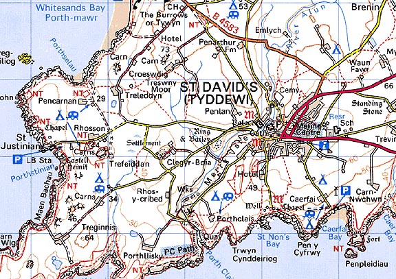
GRID REFERENCE: SM744248
AREA IN HECTARES: 30.4
Historic Background
A small area of modern Pembrokeshire on the south side of St David's peninsula.
It lay within the medieval Cantref Pebidiog, or 'Dewisland', which was
held directly by the Bishops of St David's, having represented the core
of the bishopric from 1082 when it was granted (or confirmed) by Rhys
ap Tewdwr, king of pre-Conquest Dyfed, to Bishop Sulien. The character
area lies within the parish of St David's. From 1115, when Bernard, was
appointed Bishop of St David's, Anglo-Norman systems of feudal government
and ecclesiastical administration were introduced into Pebidiog, which
was conterminous with the later Hundred of Dewsland created in 1536. However,
Welsh tenurial systems appear to have persisted, though variously adapted,
and many feudal rights and obligations continued even into the early 20th-century.
This character area comprises the valley of the River Alun, immediately
southwest of St David's Cathedral Close. It has been known since the early
17th-century as 'Merryvale' - an English rendering of Hoddnant, the name
of the valley within which St David founded his church, which was also
known as glyn rhosyn ('Rosinam Vallem' in c.1200). A ringwork-and-bailey
castle ('Parc-y-castell') was built on the west side of the valley, either
by Norman King William I on his visit to the cathedral in 1081, or by
Bishop Bernard (or one of his immediate successors). The castle appears
to have been the early administrative centre of Pebidiog and the territorial
see, until the construction of the Bishop's Palace at St David's in the
late 12th-century, when it was probably abandoned. The mint which operated
at St David's during the 1090s, on behalf of the crown, may have been
located within the castle, suggesting an earlier, rather than a later
date for its construction. A mill-leat taken off of the Alun runs through
the area supplying Dewiston Mill which is possibly the site of the mill
frequently mentioned in the Black Book of St David's of 1326, whose origins
are probably in the 13th century. It remained working until the mid 20th-century.
The remainder of the area was held as common land, part of it being associated
with the medieval and later vill of Clegyr-Boia, the remainder associated
with the borough of St David's within which the east bank of the Alun
lay. This common land is shown on the tithe map of 1840 where is occupies
much the same area as today, which may indicate its original limit.
Base map reproduced from the OS map with the permission
of Ordnance Survey on behalf of The Controller of Her Majesty's Stationery
Office, © Crown Copyright 2001.
All rights reserved. Unauthorised reproduction infringes Crown Copyright
and may lead to prosecution or civil proceedings. Licence Number: GD272221
Description and essential historic landscape components
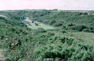
Dyffryn Alun historic landscape character area comprises that part of
the Alun valley which lies downstream of the city of St David's and upstream
of Porth Clais. The narrow floodplain lies at approximately 5m - 10m.
The valley sides are covered in dense gorse and other scrub, and rise
steeply to approximately 30m. Close to the city the small, irregular fields
on the valley floor are given over to unimproved pasture. The old earth
and earth and stone boundaries are now largely stripped of their hedges
and wire fences provide stock-proof barriers. Lower down the valley the
floor becomes wet and marshy, and the fields are abandoned and not used
for agriculture. Dewiston Mill lies on the valley floor, and the earthworks
of a medieval castle on the valley side. A modern sewage works has been
constructed on the lower end of the valley floor. Dewiston (Felin Isaf)
Mill and outbuilding are both Grade II listed.
Recorded archaeology comprises neolithic and Roman finds near Parc-y-castell, the scheduled medieval ringwork-and-bailey, with its possible mint site, and there is also a medieval findspot near Porthclais. The medieval dovecote to the north of the area, and the medieval mill-leat, are also both scheduled.
The marshy and/or scrubby vegetation of this largely unenclosed historic landscape character area stands in sharp contrast with the surrounding areas of farms and fields. It is a distinctive historic landscape area.
Sources: Boon 1986; Charles 1992; James 1981; Soulsby 1983; St David's tithe map and apportionment, 1840-41; Willis Bund 1902