|

COMIN: DOWROG - TRELEDDYD - TRETIO 
GRID REFERENCE: SM771273
AREA IN HECTARES: 218.7
Historic Background
An area of modern Pembrokeshire lying centrally within St David’s
Peninsula, which appears to have been open, wet common throughout history.
It lay within the medieval Cantref Pebidiog, or ‘Dewisland’,
which was held directly by the Bishops of St David’s, having represented
the core of the bishopric from 1082 when it was granted (or confirmed)
by Rhys ap Tewdwr, king of pre-Conquest Dyfed, to Bishop Sulien. From
1115, when Bernard, was appointed Bishop of St David’s, Anglo-Norman
systems of feudal government and ecclesiastical administration were introduced
into Pebidiog, which was conterminous with the later Hundred of Dewsland
created in 1536. However, Welsh tenurial systems appear to have persisted,
though variously adapted, and many feudal rights and obligations continued
even into the early 20th-century. The area comprises a number of distinct,
but united expanses of unenclosed land, by far the largest of which is
‘The Dowrog’, whose name is derived from dwfr, ‘water’,
and the suffix -og meaning a ‘watery place or marsh’, indicating
that the land was always wet, though peat-cutting was undertaken in drier
areas. First mentioned in 1670, The Dowrog does not appear in the Black
Book of St David’s of 1326, and so presumably was never subject
to formal, manorial common administration, and was treated as informal
waste. However, a small area to the northwest was waste or ‘moor’
belonging to the medieval vill of Treledydd, while a larger area to the
northeast was the formal Tretio Common. Here, clearly defined encroachments
appear to be ‘quillets’ of open fields rather than squatter
encroachments, possibly representing 13th- or 14th-century encroachments
from the vill of Tretio. In general, the very wet nature of the area has
prevented concerted efforts at encroachment. Part of the area is now managed
by the West Wales Wildlife Trust.
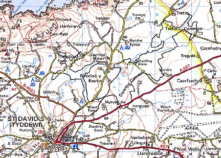
Base map reproduced from the OS map with the permission
of Ordnance Survey on behalf of The Controller of Her Majesty's Stationery
Office, © Crown Copyright 2001.
All rights reserved. Unauthorised reproduction infringes Crown Copyright
and may lead to prosecution or civil proceedings. Licence Number: GD272221
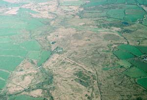
Description and essential historic landscape components
This historic landscape character area consists entirely of unenclosed
common. It covers of several interconnected tongues of land which occupy
the bottoms of hollows and open valleys in the centre of St David’s
parish, lying between 45m and 55m. It is a wet area, marshy and peaty,
with occasional stretches of open water. Very little grazing now takes
place, and on the few drier areas scrubby woodland is beginning to develop.
Peat was formerly cut on the common. There are no settlements or buildings
within the area.
Recorded archaeology is limited to a bronze age standing stone and possible round barrow, a Roman findspot, peat cuttings and a post-medieval gravel-pit.
This is a very well defined historic landscape character area. It is surrounded by a landscape of fields and farms.
Sources: Charles 1992; James 1981; Lewis 1833; St David’s tithe map and apportionment, 1840-41; Willis-Bund 1902