|

294 TYDDEWI 
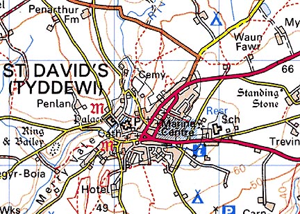
GRID REFERENCE: SM 754254
AREA IN HECTARES: 66
Historic Background
An area of modern Pembrokeshire corresponding to the built up area of the City of St David's. The origins of St David's lie in an ecclesiastical settlement of the 6th century. The cult of Dewi, and the associated tradition of pilgrimage, appear to have early origins, and were, by the 9th century, firmly associated with St David's. The association received impetus from the recognition of the episcopate by the Norman King William I who visited the site in 1081, and from the indulgence of Popo Calixtus, of 1123, that two journeys to St David's were equal to one journey to Rome. The entire Cantref of Pebidiog appears to have become an episcopal possession by c. 1100, largely through the gift (or confirmation) of the King of Dyfed Rhys ap Tewdwr in 1082. The form of the monastic settlement in this period is unknown, although it has been suggested that the present quadrangular close, which dates from the 13th- and 14th-century, may preserve an early boundary.
The appointment of a Norman bishop, Bernard, introduced Anglo-Norman systems of feudal government and ecclesiastical administration, although some earlier intervention and control is indicated by the construction of an earthwork castle in Dyffryn Alun, some distance west of the cathedral and later town, presumably contemporary with, and containing the royal mint established during William II's reign. The high medieval cathedral features some of the best ecclesiastical architecture in Wales, matched by the secular grandeur of the Bishop's Palace. An entirely new cathedral, consecrated in 1131, was constructed by Bishop Bernard replacing any pre-existing structure(s), and was itself replaced by the present building between 1176 and 1197. St Mary's College, which with its cloister lies on the north side of the church, was established in 1377.
Construction of the neighbouring Bishop's Palace probably commenced during the 12th century, having accommodated King Henry II and his retinue in 1171-2, but received its present form during the late 13th- and 14th-century. A map of 1720 shows the close at the height of its development, with fishponds, fields and orchards occupying part of its interior. At least one other post Anglo-Norman Conquest religious house existed within the city, namely Whitewell, which was established as a hospice in 1287 but was annexed to St Mary's College in 1377. Nothing is known of any civilian settlement prior to 1115 when St David's was established as a borough, receiving its first charter from King Henry I. Borough administration was on Anglo-Norman lines; the tenants occupying formal burgage tenements, one of which was, in 1326, held by co-owners in a solitary relic of Welsh tenure. Two annual fairs and a twice-weekly market were granted in 1281.
In 1326, the population of c. 1000 occupied 130 burgages, but there is little evidence of formal planning. Essentially the borough comprised a triangular market-place outside the main, east gate of the cathedral close, from which led four linear streets and an informal arrangement of smaller lanes. The arrangement of burgage plots has survived relatively intact. The Speed map shows that the town was in decline by the 16th century, with a mere 51 houses, widely spaced, and Camden, writing in the 1680s, described it as 'a very small poore Citie and hath nothing at all to make shew of.' The city did expand beyond its medieval confines, and an early 19th-century estate map shows the then newly created New Road, but it was still little more than a large village.
Base map reproduced from the OS map with the permission
of Ordnance Survey on behalf of The Controller of Her Majesty's Stationery
Office, © Crown Copyright 2001.
All rights reserved. Unauthorised reproduction infringes Crown Copyright
and may lead to prosecution or civil proceedings. Licence Number: GD272221
Description and essential historic landscape components
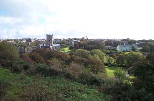
Tyddewi - St David's City - is essentially an urban historic landscape character area. Historically the focus of the city is the cathedral close, which lies on the valley floor and lower valley sided of the Afon Alun, with a secondary, secular centre focused on Cross Square on higher ground to the east. The medieval walls of the cathedral close, including Porth y Twr gatehouse, enclose St David's Cathedral, the ruined medieval Bishop's Palace and several dwellings associated with the cathedral. The latter are mostly of 18th- and 19th-centuty date, stone built and in the polite Georgian tradition. They, together with the medieval buildings, provide architectural coherence to this part of the city. The secular city is not planned, and consists of several streets, Nun Street, High Street, and Goat Street, which converge into Cross Square. It is along these streets that medieval burgage plots were laid out, and it is along these streets that the oldest buildings are to be found. The oldest surviving buildings are of 18th- and 19th-century date, and are in a variety of styles and materials, ranging from dwellings in the Georgian style built of coursed stone, through to vernacular cottages of colour-washed stone with cement-skimmed slate roofs. Interspersed with these older buildings are later 19th-century stone-built terrace houses, 19th century chapels, 20th century houses, and 20th century shops, banks and halls. At the junction of Goat Street, Pit Street and Catherine Street is a distinctive grouping of 19th century stone-built warehouses. Overall, the relatively narrow streets, the use of local stone and slate roofs lends a coherence to the historic core of Tyddewi despite the architectural diversity of the buildings. Prior to the 20th century, post medieval development outside the historic core was not extensive and is mainly limited to the creation of New Street in the late 18th century, and the establishment of settlements on the former open fields beyond the city's boundaries. The second half of the 20th century has witnessed the creation of housing estates, small scale housing development, schools, garages, hotels, sports facilities and a cemetery on the fringes of the historic core.
There are 119 listed buildings in St David's. Within the close are the cathedral church, St Mary's College and Cloister, the Bishop's Palace and the houses of the various archdeacons, canons and prebendaries, which are mainly Grade I, II* and II listed, while the close walls, Porth y Twr, steps and bridges are similarly listed. The 82 listed buildings within the town are mainly Grade II, late 18th- and early 19th-century town houses, although the old market cross, a number of non-conformist chapels and a warehouse are also included on the list.
Recorded archaeology is mainly associated with the medieval cathedral close, which along with Porth y Twr, St Mary's College, a fishpond and the 'chanters' orchard' in the close, are scheduled and have recently been subject to a large-scale archaeological survey, but there is a possible bronze age standing stone on the eastern edge of the area, while early medieval finds have been recorded within the close. Whitewell Chapel and Well are both scheduled, and a mill site has been recorded.
Although this is a well-defined, urban historic landscape character area, its boundaries over the past half a century have expanded considerably, and it now encompasses what were former open fields. It is likely that its boundaries will encroach further upon neighbouring areas over the forthcoming decades.
Conservation Priorities
Maintenance of the settlement morphology and of individual buildings is essential for the continuance of this distinctive historic landscape area. Conservation should be given to design, materials and location before new development is permitted. Development should be consistent with St David's Conservation Area Status.
Sources: Boon 1986; Green 1927; Evans 1991; Fenton 1811; James 1981; James 1993; Jones and Freeman 1856; Soulsby 1983; St David's tithe map and apportionment, 1840-41; Pembrokeshire Record Office D/RTP/HIG/13; Turner 2000; Willis Bund 1902