|

298 MIDDLE MILL 
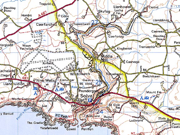
GRID REFERENCE: SM805258
AREA IN HECTARES: 105
Historic Background
An area of modern Pembrokeshire on the south side of St David's Peninsula,
comprising the valley of the Afon Solfach around Middle Mill, upstream
of Solva village. It lay within the medieval Cantref Pebidiog, or 'Dewisland',
which was held directly by the Bishops of St David's, having represented
the core of the bishopric from 1082 when it was granted (or confirmed)
by Rhys ap Tewdwr, king of pre-Conquest Dyfed, to Bishop Sulien. The character
area now lies within Whitchurch parish but formerly lay within the historic
parish of St David's, which even today preserves a remarkable ecclesiastical
topography. A medieval hospice site may be represented by a place-name,
'Clyn Ysbyty', which has been in use since at least 1610. From 1115, when
Bernard was appointed Bishop of St David's, Anglo-Norman systems of feudal
government and ecclesiastical administration were introduced into Pebidiog,
which was conterminous with the later Hundred of Dewsland created in 1536.
The character area lay within the 'manor' of Welsh Hundred and Tydwaldy
but Welsh tenurial systems appear to have persisted, though variously
adapted, and many feudal rights and obligations continued even into the
early 20th-century. The character area is dominated by the Afon Solfach
which was thought worthy of mention by Giraldus Cambrensis in c.1200.
Pebidiog had long been renowned for its fertile arable land and accordingly
a corn-mill at Solva is mentioned in the Black Book of St David's of 1326,
which may represent the present Solva mill in the south of this character
area. Caerforiog Mill, in the north, is not listed in the Black Book but
appears also to have medieval origins, and its pond - Llyn-yr-alarch or
'Swan's Pool' - features a possible moated site and a former dovecote
(see Caerforiog character area). Middle Mill was also not listed in 1326
and its name presupposes that it was the latest of the three mills. Middle
Mill Bridge was mentioned by name in a document of 1598, indicating that
a mill had by been established. Both Solva and Middle Mill possessed rights
of common grazing within the area suggesting that the allocation of common
land in Pebidiog may, at least in part, be post-medieval in origin. Middle
Mill Farm corn mill, presumably on the site of the 16th century mill,
is marked on a map from 1760, as is the Mill House, and was still operational
as a corn mill in 1812. However, by this period Middle Mill had developed
as a centre of the post-medieval cloth industry. In the 17th century,
2500 acres of land including Middle Mill were sold to a London mercer
and in the 1830s the highest density of woollen mills for any one Pembrokeshire
district was seventeen in the neighbourhood of St David's. They included
Middle Mill around which a 19th century semi-industrial village developed,
with a chapel and a public house. The present cloth factory, however,
was not established until 1907. Under the name 'Thomas Griffiths and Son'
it exported throughout the UK, and more recently has been a carpet factory.
Base map reproduced from the OS map with the permission
of Ordnance Survey on behalf of The Controller of Her Majesty's Stationery
Office, © Crown Copyright 2001.
All rights reserved. Unauthorised reproduction infringes Crown Copyright
and may lead to prosecution or civil proceedings. Licence Number: GD272221
Description and essential historic landscape components
Middle Mill historic landscape character area occupies the valley floor
and valley sides of the River Solva upstream from Solva village. The valley
floor lies at between 5m to 10m and the sides rise steeply to over 50m.
Downstream of the hamlet of Middle Mill the narrow floodplain and lower
valley sides are enclosed into small fields of improved pasture by banks
of earth or earth and stone. The hedges on these banks are neglected and
overgrown and are no longer stock-proof. Wire fences provide stock-proof
barriers. The valley sides and the floor of the valley above Middle Mill
are covered with either deciduous woodland and/or scrubby woodland with
a high percentage of gorse. Along the winding lane between Solva village
and Middle Mill are several dispersed 19th century cottages in the vernacular
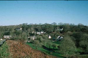
tradition and modern bungalows in a variety of styles. Middle Mill, as
the name indicates, is a small, semi industrial hamlet. It is centred
on a water-powered woollen mill of 19th- and 20th-century date, now a
tourist attraction, and consists of a cluster of mainly 19th century stone-built
houses and cottages in the vernacular tradition, many of which are restored,
and a chapel, located on the lower, eastern valley side. A large quarry
- still partly active - with concrete-built buildings lies on the upper,
western valley side overlooking Middle Mill hamlet. A water treatment
works is located on the valley floor.
There are five listed buildings in Middle Mill. The Mill House and mill, and Middle Mill Farm corn mill with overshot wheel, both of which are essentially 18th century and are marked on a map from 1760, the Baptist chapel, Middle Mill bridge and Caerforiog Bridge mentioned in 1598. Unlisted buildings include the Llanwas Arms and the Flannel Factory, and outside the village, Caerforiog and Solva Mills, and the bridges of Pont-y-cerbyd and Pont Ifangwr.
Recorded archaeology is limited to a bronze age findspot, a possible iron age hillfort, the scheduled, rectangular medieval moated enclosure at Llyn-yr-alarch, a possible medieval 'hospice' place-name, and post-medieval quarries and gravel-pits.
The wooded valley and relatively late settlement pattern of the area distinguish it from the neighbouring historic landscape character areas of old established fields and farms. Middle Mill is a distinct historic landscape character area.
Sources: Charles 1992; Fenton 1811; James 1981; Jones 1966-70; Ludlow 1994; National Library of Wales, NLW Coll B488; Whitechurch (St David's) tithe map and apportionment, 1840-41; Willis-Bund 1902