|

302 RAMSEY 
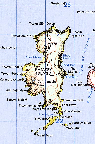
GRID REFERENCE: SM704244
AREA IN HECTARES: 86.7
Historic Background
An area of modern Pembrokeshire occupying the northeastern half of
Ramsey Island, off the western tip of St David's Head. Administratively,
the island formed part of the medieval Cantref Pebidiog or 'Dewisland',
which was held directly by the Bishops of St David's, having represented
the core of the bishopric from 1082 when it was granted (or confirmed)
by Rhys ap Tewdwr, king of pre-Conquest Dyfed, to Bishop Sulien. Historically,
the island formed part of the parish of St David's, and contained two
medieval chapel sites which may have early medieval origins, one of which
- dedicated to St Tyfannog - lies in this character area. It is associated
with a holy well site, a cemetery and an inscribed stone which may commemorate
a 9th century bishop. It has been suggested that the relationship between
the island and the monastery at St David's may be analogous to that between
Llancarfan and Flatholm in the Bristol Channel, as an island retreat for
the monastic community. The island is laden with legends from its past
inhabitants, many of them supernatural and involving the fairies Y Tylwyth
Teg and Plant Rhys Dwfn; others tell of the sound of bells beneath the
sea. During the post Anglo-Norman conquest period, Ramsey Island, and
particularly the well, was an important pilgrimage site. From 1115, when
Bernard was appointed Bishop of St David's, Anglo-Norman systems of feudal
government and ecclesiastical administration were introduced into Pebidiog,
which was conterminous with the later Hundred of Dewsland created in 1536.
However, adapted Welsh tenurial systems appear to have persisted. Ramsey
became a fairly productive part of the Bishop's lands, and an Inquisition
Post Mortem of 1293 indicates that the island was fertile and that a wide
range of mixed farming was practised. Beef cattle, sheep and goats, and
also wheat, oats and barley are recorded. A more detailed account in the
Black Book of St David's of 1326, records that the bishop had 2 carucates
of land on the island, containing 100 acres, on which could be kept 10
horses, 100 head of 'great cattle' and 300 sheep. 100 loads of rushes
and heath were taken per annum, and 500 rabbits 'for cooking' worth 33s
4d. The island was also exploited for gull, guillemot and puffin eggs.
The field pattern in this character area was in place by the early 19th-century
and appears to be more recent than the relict boundaries in the Carn Llundain
- Caer Ysgubor character area, which may be bronze age in origin. Originally
this bronze age system may have extended over this half of the island,
and some of the extant boundaries here may perpetuate the line of earlier
boundaries. A farmhouse on the island, adjacent to a corn mill and lime-kiln,
was occupied by one William Browne in 1543-4 but the present house was
constructed in c.1800, the old building being in ruins when visited by
Fenton in c.1811. Farming continued well into the 20th century, and in
the 1900s was undertaken by the Arnold brothers who grew barley, potatoes,
turnips and peas, rearing sheep and some pigs and horses. A corn mill
and lime-kiln were both then still operational. The island remained an
ecclesiastical holding until sold into private hands in 1905. It is now
owned and managed by the RSPB.
Base map reproduced from the OS map with the permission
of Ordnance Survey on behalf of The Controller of Her Majesty's Stationery
Office, © Crown Copyright 2001.
All rights reserved. Unauthorised reproduction infringes Crown Copyright
and may lead to prosecution or civil proceedings. Licence Number: GD272221
Description and essential historic landscape components
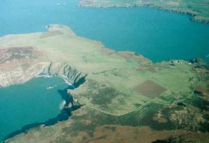
Ramsey historic landscape character area consists of that part of Ramsey
Island which contains an in-use field system, essentially the northeast
corner of the island. This is the most sheltered part of the island, and
comprises a shelving tract of land that slopes down from 55m in the west
to 30m on the eastern side where it ends in high sea cliffs. Dry-stone
walls and stone-faced banks divide the area up into medium- to large-sized
irregular fields. Boundaries are generally in a good state of repair.
Land-use is predominantly pasture. It is a treeless landscape. A stone-built
19th century farmhouse in the vernacular style with an extensive range
of 19th century stone-built farm buildings is situated on the cliff tops
above a landing place/quay. The farmhouse is Grade II listed. The buildings
are roofed in slate and asbestos sheet.
Recorded archaeology comprises a mesolithic-neolithic findspot, a possible bronze age standing stone site, the medieval chapelry with a St Tyfannog dedication, cemetery and inscribed stone, and the mill, quay and lime-kiln sites.
Ramsey is a distinct and well defined historic landscape character area. It is bounded to the north and east by the sea, and to the west and south by unenclosed moorland.
Sources: Fenton 1811; James 1981; James 1993; James and James 1994; Jones 1996; St David's tithe map and apportionment, 1840-41; National Library of Wales 14229/6 Map 84; Willis-Bund 1902