Home > Historic Landscape Characterisation > Drefach-Felindre > |

 DYFFRYN BARGOD AND DYFFRYN ESGAIR
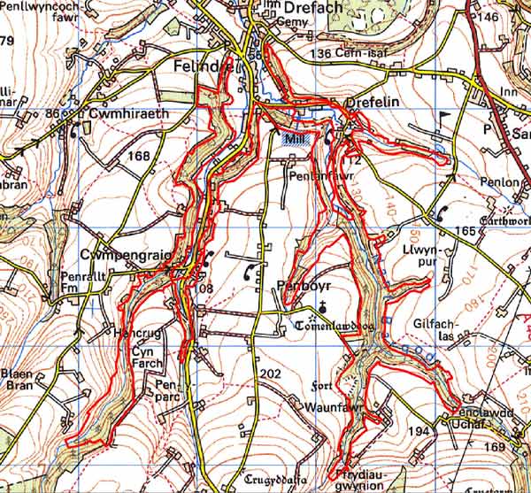
GRID REFERENCE: SN348367
AREA IN HECTARES: 171
Historic Background
A small area within modern Carmarthenshire consisting of the steep-sided valleys of Nant Bargod and its tributary Nant Esgair. It mainly comprises heavily-wooded valley slopes. The area lay within the medieval Cantref Emlyn, in Emlyn Uwch-Cych commote. Cantref Emlyn had been partly brought under Anglo-Norman control in c.1100 when Emlyn Is-Cych commote, to the west, was reconstituted as the Lordship of Cilgerran. Numerous castles were established in Uwch-Cych - none of which has any recorded history - but the commote was back under Welsh control by the 1130s, and it remained such throughout the 12th and early 13th centuries. It was appropriated by the Anglo-Norman Marshal Earls of Pembroke in 1223, but was granted to Maredudd ap Rhys, with whose family it remained until finally annexed by the English crown in 1283. It eventually formed part of the Hundred of Elvet in Carmarthenshire, in 1536, when Is-Cych joined Pembrokeshire. Uwch-Cych was granted to royal favourite Sir Rhys ap Thomas in the late 15th century, reverting to the crown in 1525 to be granted, in 1546, to Sir Thomas Jones of Haroldston, Pembrokeshire. It remained in this family for several generations, eventually passing by marriage to the Vaughans’ Golden Grove Estate, which in the 19th century still owned almost all the land on the southern side of the Teifi from Pentre-cwrt in the east to Cenarth in the west. The medieval Welsh tenurial pattern - with neither vills nor knight’s fees - has been largely responsible for the dispersed settlement within the region. Indeed little settlement has occurred within this area, although the first large-scale cartographic representation of this area - estate maps of 1778 - show a lot less woodland than today, with more fields on steep valley sides. By the tithe survey of c. 1840 more woodland is shown, but it is still less than today. Since that date woodland has either regenerated over former fields or been planted. Since World War 2 coniferous woodland has been planted, either in small pockets between deciduous trees, or as more extensive cover on the higher slopes towards the southern part of this area.
Description and essential historic landscape components
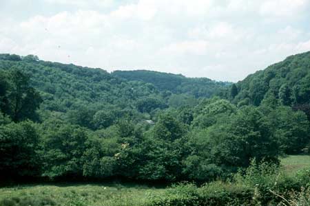
This heavily wooded historic landscape character area lies on the steep valley sides of the north-flowing streams, Nant Bargod and Dyffryn Esgair. The lower valley sides at the northern end lie at about 50m above sea level. At the southern end the highest point of the valley sides rises to over 200m above sea level. Apart from a few fields of scrub and rough pasture, the whole is wooded. This is a mixture of deciduous woodland and coniferous plantations. Deciduous woodland predominates at the northern lower end of the character area on the valley sides above the villages and hamlets of Drefach, Felindre, Cwmpencraig and Drefelin, with coniferous plantations more common on the higher ground to the south. Some of the deciduous woodland is ancient, some may be relatively recent regeneration and some may be plantations.
There are no standing buildings in this area, but several ruined cottages associated with the Drefach – Felindre woollen industry are recorded on the Regional Historic Environment Record, as well as several mill leats that once fed woollen mills. Other archaeological sites are few, but include an Iron Age hillfort, and several old quarries of probable of 19th century date.
This is a distinctive historic landscape character area. It contrasts sharply with the neighbouring agricultural character areas and industrial/settlement areas.
Sources: Cadw –Carmarthen Record Office c/v
5885 Newcastle Emlyn Estate – The Property of John Vaughan 1778;
Craster, O E, 1957, Cilgerran Castle, London; Lewis, S, 1833, A Topographical
Dictionary of Wales 1 & 2, London; Llangeler parish tithe map 1839;
Lloyd, J E, 1935, A History of Carmarthenshire, Volume I, Cardiff; Penboyr
parish tithe map 1840; Rees, W, 1932, ‘Map of South Wales and the
Border in the XIVth century’; Rees, W, 1951, An Historical Atlas
of Wales, London; Regional Historic Environment Record housed with Dyfed Archaeological Trust
Base map reproduced from the OS map with the permission
of Ordnance Survey on behalf of The Controller of Her Majesty's Stationery
Office, © Crown Copyright 2001.
All rights reserved. Unauthorised reproduction infringes Crown Copyright
and may lead to prosecution or civil proceedings. Licence Number: GD272221