Home > Historic Landscape Characterisation > Drefach-Felindre > |

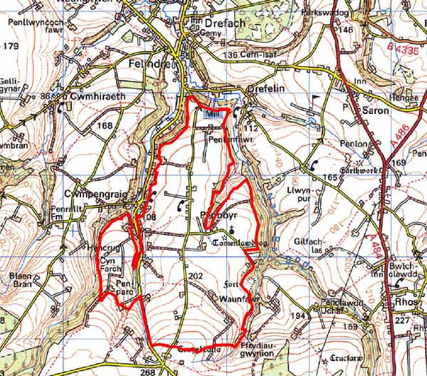
 PENBOYR
GRID REFERENCE: SN353364
AREA IN HECTARES: 361
Historic Background
This is a small area within modern Carmarthenshire consisting of regular rectangular fields and dispersed farms. It lies within the medieval Cantref Emlyn, in Emlyn Uwch-Cych commote. Cantref Emlyn had been partly brought under Anglo-Norman control in c.1100 when Emlyn Is-Cych commote to the west was reconstituted as the Lordship of Cilgerran. Numerous castles were established in Uwch-Cych comote - none of which has any recorded history - but the commote was back under Welsh control by the 1130s, where it remained throughout the 12th and early 13th centuries. A motte-and-bailey castle, ‘Tomen Llawddog’, was established within this character area, immediately next to Penboyr parish church, St Llawddog’s; and therefore the may be contemporary. It is not known whether they belong to the brief period of Anglo-Norman control, or are Welsh foundations of the later 12th century. However, the church dedication to St Llawddog may be later medieval, when his cult was still active in the area. The church was first recorded in 1222 when it was ‘restored’ to the Bishops of St Davids, to be counter-claimed by the crown. Its early parish status, along with its close relationship to the castle, suggests that the two represent a deliberate Anglo-Norman plantation. They may therefore represent the site of a failed vill. The castle, which has no recorded history, probably become disused at an early date. They never became the focus for any later settlement, nucleated or otherwise.
Uwch-Cych commote was appropriated by the Anglo-Norman Marshal Earls of Pembroke in 1223, but was granted to Maredudd ap Rhys, with whose family it remained until finally annexed by the English crown in 1283. In 1536 it formed part of the Hundred of Elvet in Carmarthenshire. Uwch-Cych was granted to royal favourite Sir Rhys ap Thomas in the late 15th century, reverting to the crown in 1525, to be granted in 1546 to Sir Thomas Jones of Haroldston, Pembrokeshire. It remained in this family for several generations, eventually passing by marriage to the Vaughans’ Golden Grove Estate, which in the 19th century still owned almost all the land on the southern side of the Teifi from Pentre-cwrt in the east to Cenarth in the west.
The medieval Welsh tenurial pattern - without (with the possible exception of Penboyr) neither vill nor knight’s fees - has been largely responsible for the dispersed settlement within the region. The present landscape throughout this character area mainly comprises medium-large, regular rectangular fields of late enclosure. They probably date from the mid-late 18th century - although some of the individual farmsteads will probably be older - and appear to be contemporary with the present road system which follows the enclosure axis and boundaries. The first large-scale historic maps of this area date to 1788 and show a landscape very similar to that of today. However the 1778 estate map of Ty Hen/Penlan Ganol hints at an earlier fieldscape. Here, in addition to the usual fairly regular field system that still prevails, intermixed strips or slangs are shown. However, they are probably not medieval, and are certainly not the formal, arable open field strips characteristic of Anglo-Norman tenure. Instead, the strips appear to represent grazing rights assigned to neighbouring farms and it would seem that at least part of this area was open land, under multiple-ownership grazing, which was undergoing enclosure in the late 18th century. By the tithe survey of 1840 the landscape is virtually identical to that of today, except for the loss of a few hedges. Although this character area lies beyond the main textile-producing area of the 19th century, there are records of weavers at several locations, presumably operating a cottage industry in cottages or small workshops.
Description and essential historic landscape components
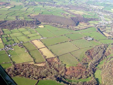
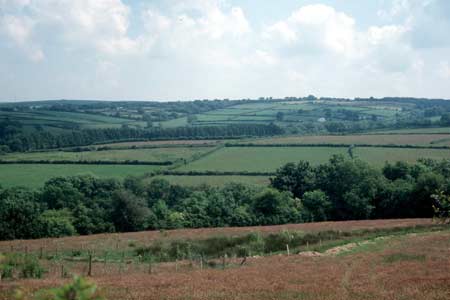
Penboyr historic landscape character area lies on the gently sloping north-facing valley side of the Afon Teifi between 120m and 260m above sea level. It is an agricultural landscape characterised by farms and small- to medium-sized, fairly regular fields. Farms are generally small with an unusually dense distribution. Boundaries consist of earth banks topped by hedges – Laburnum is contained in some hedges. At higher levels to the south of this area hedges are overgrown and in some instances reduced to straggling lines of bushes with many small trees, but in the more sheltered north they are in better condition. Stone is the main building material, in particular Teifi valley slate, which is usually of uncoursed rubble, but coursed with cut stone on better quality buildings. Commercial north Wales slate is the ubiquitous roofing material. All the older buildings date to the mid to later 19th century. Farmhouses are generally in the typical southwest Wales style – two-storey and three-bay with a central front door and five symmetrically arranged windows – but with strong vernacular traits, such as small window openings and low elevations, rather than in the more ‘polite’ Georgian tradition. There are exceptions to this, such as the two-storey, mid 19th century listed ‘Georgian’ house of cut and coursed Teifi valley stone at Penlanfawr. Some farmhouses have been rebuilt as bungalows in the late 20th century, and there is a scattering of other bungalows and houses across the area of a similar date. Late 19th century two storey and single storey worker houses are also present. Agricultural farm buildings are generally small, with older examples stone built, and modern ones of steel, concrete and asbestos. Some of the smaller farms are no longer engaged in agriculture and their outbuildings are disused. The medieval Penboyr parish church, which was entirely rebuilt in the 19th century, and the neighbouring Tomen Llawddog motte-and-bailey castle are the major archaeological sites in the area. The bailey of the castle is damaged and half the motte has been removed. Other recorded archaeology is mainly confined to sites, workshops and cottages that were engaged in the woollen industry in the 19th century.
It is a well-defined historic landscape area. To the west, north and east steep-sided heavily wooded valleys define it. To the south more irregular fields of 18th and 19th century form a zone of change rather than a hard-edged boundary.
Sources: Cadw – database of Building of Special
Architectural or Historic Interest; Carmarthen Record Office c/v 5885
Newcastle Emlyn Estate – The Property of John Vaughan 1778, maps
70, 72,76, 80, 82, 87, 89; Craster, O E, 1957, Cilgerran Castle, London;
Jones, D E, 1899, Hanes Plwyfi Llangeler a Phenboyr, Llandysul; King,
D J C, 1988, Castellarium Anglicanum, New York; Lewis, S, 1833, A Topographical
Dictionary of Wales 1 & 2, London; Lloyd, J E, 1935, A History of
Carmarthenshire, Volume I, Cardiff; Ludlow, N, 2000, ‘Spiritual
and Temporal: Church-building in medieval and later Carmarthenshire’,
Carmarthenshire Antiquary 36, 71-86; Ludlow, N, 2000, ‘The Cadw
Welsh Historic Churches Project: Carmarthenshire churches’, unpublished
report by Dyfed Archaeological Trust; Penboyr parish tithe map 1840; Rees, W,
1932, ‘Map of South Wales and the Border in the XIVth century’;
Rees, W, 1951, An Historical Atlas of Wales, London; Regional Historic Environment Record housed with Dyfed Archaeological Trust
Base map reproduced from the OS map with the permission
of Ordnance Survey on behalf of The Controller of Her Majesty's Stationery
Office, © Crown Copyright 2001.
All rights reserved. Unauthorised reproduction infringes Crown Copyright
and may lead to prosecution or civil proceedings. Licence Number: GD272221