Home > Historic Landscape Characterisation > Drefach-Felindre > |

 RHOS PENBOYR
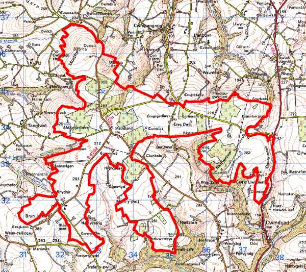
GRID REFERENCE: SN333336
AREA IN HECTARES: 1584
Historic Background
A large area within modern Carmarthenshire, comprising an extensive ridge of high ground separating the Teifi valley to the north from the Tywi valley to the south. It was open moorland, named ‘Mynydd Castell Newydd ‘on Emmanuel Bowen’s map of 1729 and was not enclosed until 1866. Historically, it presented a considerable barrier to travellers. Indeed its western end is named ‘Fose y Gelin’ by Bowen, with the warning ‘A Dangerous Bogg which Strangers ought to be cautious of Crossing in ye Winter Season without Guides’. In common with similar landscapes elsewhere in southwest Wales, the main historic landscape component is represented by prehistoric monuments; including 15 Bronze Age round barrows, which were intentionally highly visible - and still are, especially the three on the summit of Mynydd Moelfre at the west end of the area - and give both visual character and time-depth to the area. No contemporary field systems have so far been recognised, although a massive linear defensive bank known as Clawdd-Mawr, crossing the eastern end of the ridge, which is early medieval, but could be much earlier.
During the historic period, the bulk of this area lay within the medieval Cantref Emlyn, in Emlyn Uwch-Cych commote which remained largely in Welsh hands until the 13th century. It was finally annexed by the English crown in 1283, and in 1536 formed part of the Hundred of Elvet in Carmarthenshire. The southern part of this character area is in Cantref Gwarthaf, Elfed commote. This was brought under Anglo-Norman control soon after the establishment of the royal castle at Carmarthen, in 1109-10, as part of the associated ‘Honour of Carmarthen’. In 1284, it became the core of the newly-formed County of Carmarthen. However, it represented the ‘Welshry’ of the lordship and county, and so a Welsh tenurial pattern persisted in both areas - with neither vills nor knight’s fees. This is largely responsible for the dispersed settlement pattern throughout the region. Indeed little settlement appears to have occurred within the Rhos Penboyr character area prior to the late 19th century. However, there is documentary evidence for lead and silver mining during the 16th and 17th centuries.
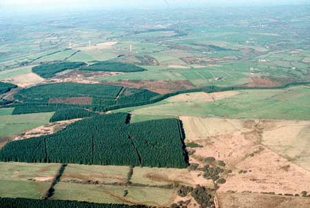
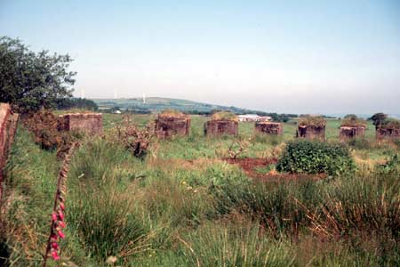
Mynydd Moelfre was formal common land during the medieval period, and the entire character area is shown as open common - essentially moorland – on tithe maps of c. 1840, although by this date its lower-lying fringes had been encroached upon by squatters, cottages had been built and fields laid out. The greater portion of common, including most of this character area, was enclosed by Act of Parliament in 1866. Regular, relatively large fields were laid out, and soon after farms and cottages built. Later intervention has been limited, although a second defensive line, the Rhos-Llangeler Stop Line, was built across the ridge west of Clawdd Mawr during World War 2. Since the war, coniferous forestry plantations have been established over some of the fields, which with three massive wind-turbines - constructed in the early 21st century on Mynydd Moelfre - are now the most prominent landscape features of the area.
Description and essential historic landscape components
Rhos Penboyr is an east-west aligned ridge, lying between 210m and 330m above sea level, forming the watershed between the Afon Teifi to the north and the Afon Tywi to the south. It is an agricultural landscape overlain in places by coniferous forestry plantation. The large regular fields and straight lanes are typical of a landscape created by Act of Parliament, in this instance in 1866. It is exposed and windswept, and consequently hedges on the earth boundary banks are either straggling lines of low bushes or non-existent. Post and wire fences are the chief stock-proof barriers. Apart from large coniferous forestry plantations, which are a major characteristic of this landscape, it is treeless. Agricultural land-use is improved pasture with occasional fields of unimproved grazing and pockets of heather/bracken moor. Farms are small and widely dispersed. Although most of the farms were established in the later 19th century, there are few buildings, either houses or farm outbuildings - that pre-date the second half of the 20th century. There are no listed buildings. Three massive turbines constructed in the early 21st century are prominent landscape features. Clawdd-Mawr defensive bank crosses the eastern end of the ridge. The World War 2 Rhos-Llangeler Stop Line is represented by anti tank cubes and pill boxes, and crosses the ridge further west. Other archaeological sites comprise over 15 Bronze Age round barrows, most of which are Scheduled Ancient Monuments, and the most prominent of which, on hilltops, are important historic landscape components and demonstrate pre-19th century use of the area.
This is a relatively well-defined historic landscape character area that essentially corresponds to the land enclosed by Act of Parliament in 1866. There has been some blurring of the boundaries since then, owing, in particular, to the establishment of coniferous plantations, but nevertheless the historic boundaries still hold good.
Sources: Bowen E, 1729 A Map of South Wales; Cadw
– database of Building of Special Architectural or Historic Interest;
Carmarthen Record Office c/v 5885 Newcastle Emlyn Estate – The Property
of John Vaughan 1778, map 54, 56; Conwil parish tithe map 1840; Jones,
D E, 1899, Hanes Plwyfi Llangeler a Phenboyr, Llandysul; Lewis, S, 1833,
A Topographical Dictionary of Wales 1 & 2, London; Llangeler parish
tithe map 1839; Lloyd, J E, 1935, A History of Carmarthenshire, Volume
I, Cardiff; National Library of Wales Ms Vol 84 (PE965) Plan of Llangeler,
Penboyr and Kilrhedin Inclosure 1866; Penboyr parish tithe map 1840; Rees,
W, 1932, ‘Map of South Wales and the Border in the XIVth century’;
Rees, W, 1951, An Historical Atlas of Wales, London; Regional Historic Environment Record housed with Dyfed Archaeological Trust
Base map reproduced from the OS map with the permission
of Ordnance Survey on behalf of The Controller of Her Majesty's Stationery
Office, © Crown Copyright 2001.
All rights reserved. Unauthorised reproduction infringes Crown Copyright
and may lead to prosecution or civil proceedings. Licence Number: GD272221