Home > Historic Landscape Characterisation > Lower Teifi Valley > |

 CARDIGAN ISLAND AND COASTAL STRIP
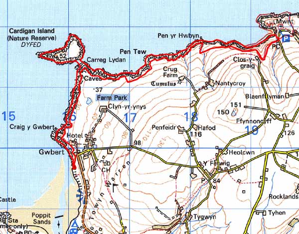
GRID REFERENCE: SN160507
AREA IN HECTARES: 64
Historic Background
This is a long, narrow area within modern Ceredigion, represented by the steep coastal cliffs between Craig-y-Gwbert and Mwnt, including Cardigan Island. During the historic period, this character area lay within Ceredigion, in the medieval Cantref Iscoed, in the commote of Is-Hirwern. Ceredigion, including Cantref Iscoed, was briefly brought under Anglo-Norman control between 1110 and 1136, under the de Clare earls. Ceredigion remained in Welsh hands throughout the 12th and 13th centuries, until finally annexed by the English crown in 1283, when the county of Cardiganshire was created. However, Is-Hirwern commote including Cardigan Island was reliquished to the Norman King John in 1201 when it became a royal lordship, administered from Cardigan Castle, until the Act of Union of 1536 when it became part of the Hundred of Troedyraur. Generally the lordship remained subject to Welsh law and tenurial patterns throughout the medieval period, administered as a ‘Welshry’ This character area lies within a subdivision of the commote, Gwestfa Berwick/Ferwig which may have pre-Norman origins. Medieval tenurial patterns - with neither vills nor knight’s fees - have been largely responsible for the dispersed settlement generally seen within the region.
The coastal strip, which is very narrow, has always been marginal land and was presumably used for rough grazing from an early period. No historic settlement sites have been recognised within this mainland strip, but evidence of post-medieval use is provided by a 19th century lime-kiln near Gwbert. Cardigan Island features a probable Bronze Age round barrow, suggesting a human presence on the island at an early date. Although some earthwork features within enclosures may be prehistoric hut platforms, they have not been dated and along with other features on the island may be medieval, or later. There is no evidence for the traditionally supposed early medieval or later monastic use of the island, and it is probable that no permanent habitations were established after the prehistoric period. However, some of the earthworks are thought to represent rabbit warrens, and there is plenty of documentary evidence for rabbit farming on other offshore islands in southwest Wales, and while none concerns Cardigan Island; there are oblique references to rabbits on the island in local lore. Some ridge-and-furrow is also present on the island, regarded as ‘ancient’ in the mid 19th century, but as the island was in the possession of the Brigstockes of Blaenpant - renowned agricultural improvers - during the 18th century, it may belong to agricultural improvement of marginal land. However, the island was only seasonally exploited during the 19th century when it ‘yielded good pasturage for cattle and sheep, chiefly for the market at Cardigan’. It is now a nature reserve.
Description and essential historic landscape components
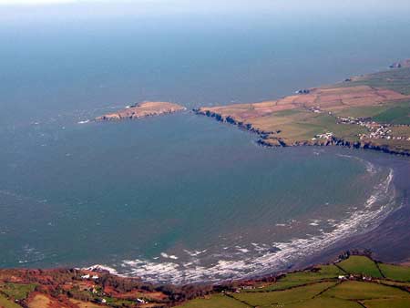
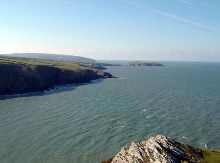
This historic landscape character area consists of Cardigan Island and the high, hard-rock cliffs rising from the sea to over 70m, from the mouth of the Afon Teifi to Mwnt cove, a distance of about 5km. The coastal strip is here rarely over 100m wide, and comprises rough grazing and waste fringing farmland as well as the sea cliffs. High cliffs surround the small area of unimproved grazing land that makes up the uninhabited Cardigan Island. There are no occupied buildings in this area, although a listed lime-kiln is recorded at Gwbert. Recorded archaeology is rich and varied and consists of numerous sites associated with earlier phases of occupation/agriculture on Cardigan Island, such as a Bronze Age round barrow, settlements, a possible rabbit warren and ponds. There is also an Iron Age hillfort on the mainland strip, post-medieval landing-places and other sites.
Cardigan Island and the coastal strip is a distinct historic character area and contrasts with the fields and farms of neighbouring character areas.
Sources: Bewers, P, 1994, ‘Cardigan Island,
Y Ferwig’, Archaeology in Wales 34, 3-6; Cadw – database of
Building of Special Architectural or Historic Interest; James, T, and
Simpson, D., 1980, Ancient West Wales from the Air, Carmarthen; Lewis,
S, 1833, A Topographical Dictionary of Wales 1 & 2, London; Ludlow,
N, 2002, ‘The Cadw Early Medieval Ecclesiastical Sites Project,
Stage 1: Ceredigion’, unpublished report by Dyfed Archaeological Trust;
Meyrick, S R, 1810, The History and Antiquities of Cardiganshire, London;
Rees, W, 1932, ‘Map of South Wales and the Border in the XIVth century’;
Rees, W, 1951, An Historical Atlas of Wales, London; Regional Historic Environment Record housed with Dyfed Archaeological Trust; Verwig parish tithe
map 1839
Base map reproduced from the OS map with the permission
of Ordnance Survey on behalf of The Controller of Her Majesty's Stationery
Office, © Crown Copyright 2001.
All rights reserved. Unauthorised reproduction infringes Crown Copyright
and may lead to prosecution or civil proceedings. Licence Number: GD272221