Home > Historic Landscape Characterisation > Lower Teifi Valley > |

 CILGERRAN GORGE
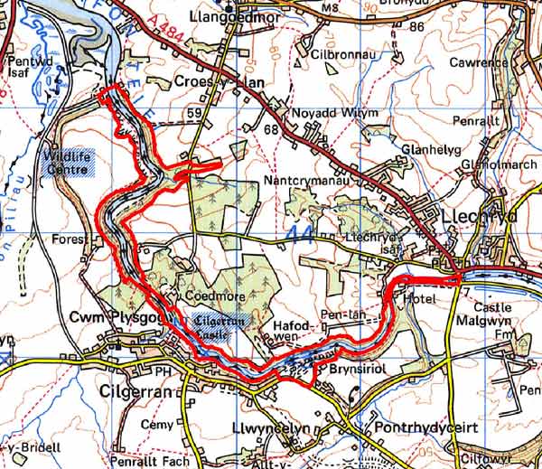
GRID REFERENCE: SN190439
AREA IN HECTARES: 82
Historic Background
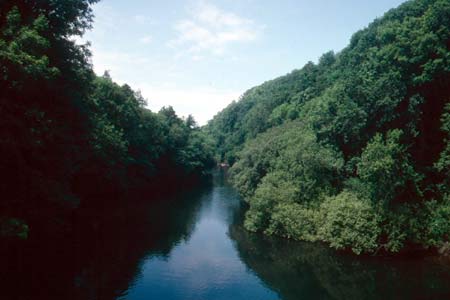
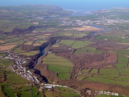
This is a long, narrow, sinuous area comprising the incised meanders of Cilgerran Gorge, where the Teifi Valley suddenly narrows from a floodplain at Llechryd into a narrow, rocky gorge. It has long been a renowned beauty spot.
This area lies within the medieval Cantref Emlyn, in Emlyn Is-Cych commote. Cantref Emlyn had been partly brought under Anglo-Norman control in c.1100 when Emlyn Is-Cych commote was reconstituted as the Lordship of Cilgerran. Cilgerran remained a marcher lordship, administered from Cilgerran Castle, which was established in c.1100. The lordship was regained by the Welsh in 1164 and remained under their rule until 1223. From 1339 it was held of the Earldom of Pembroke, which passed to the crown in the late 15th century. It was eventually abolished in 1536, when the lordship was incorporated into Pembrokeshire as the Hundred of Cilgerran. The medieval lordship, administered as a ‘Welshry’, remained subject to Welsh laws, customs and tenurial systems throughout the period. This - - with neither vills nor knight’s fees - has been largely responsible for the dispersed settlement within the region.
The gorge passes below Cilgerran Castle itself, which was rebuilt in stone during the 1220s-1230s and still dominates the landscape. The gorge below the castle is noted for its fishing, particularly salmon, which has a long history. By 1270, the Lord of Cilgerran’s salmon weir below the castle had six traps, and complaints were made that they impeded river traffic carrying stone downstream for the king’s building works at Cardigan Castle. The traps were ordered to be removed, but were rebuilt in 1314 by the Lord of Cilgerran, in manner that did not interfere with river traffic. The six traps were described by George Owen in 1603 as ‘the greatest weir of all Wales’. The fishery continued to be operated by the burgesses of Cilgerran through the post-medieval period, the building where the fish were taken to be weighed - ‘Ty’r goved’, being located immediately below the castle. Coracle fishing was also undertaken in the gorge until recent years.
Another economic asset of the gorge that had been exploited since the medieval period is stone - the durable Teifi Valley slate stone that characterises so many buildings in the region. It is the stone from which Cilgerran Castle itself is made, physical evidence of an industry which is recorded in the reputed rights of the burgesses of Cilgerran to dig for stone, without payment, for their own use. A fee was payable if the stone was taken outside the borough. Seventeenth century leases also refer to slate quarrying . Despite this long history of quarrying for both building stone, and roofing slate, the industry seems to have been limited to numerous small workings until the mid 19th century. However, from the 1850s-1860s onwards, the industry was mechanised using steam power, and the arrival of the Whitland and Cardigan Railway at Cilgerran, in 1885, allowed for greater export. These factors led to the emergence of larger enterprises, with smaller quarries still serving local needs. The decline in the slate industry began in the early decades of the 20th century, and production of stone and slate ceased in the 1930s, although some bulk extraction was undertaken in the latter part of the century. There are two main groups of quarries, the Town Quarries on the slopes below the town and Fforest a little way downstream. Despite all this activity the valley retained a rural aspect, and even at the peak of the industry contemporary maps, such as the tithe map of c.1840, show the sides of the gorge as heavily wooded. These wooded slopes, with the castle, and the river below, have long been renowned as a beauty spot, attracting the attention of Romantic tourers and artists of the 18th and early 19th centuries, In search of the ‘Picturesque’, they would slowly coast downstream in order to view, sketch and paint the ruins of Cilgerran Castle. They included Richard Wilson, and J M W Turner who made several studies of the castle. The gorge itself attracted their attention - Samuel Lewis, in 1833, described the ‘sylvan beauties of the scene... rich groves, alternating with the naked rock, continue to excite the admiration of the traveller’.
Description and essential historic landscape components
This historic landscape character area consists of approximately 5km of the Teifi valley from where it suddenly narrows from a floodplain upstream at Llechryd to where it enters tidal marshes at Rosehill/Pentood. The lower stretches of the river are tidal. From the river the valley sides rise steeply to over 50m above sea level. Numerous extensive, old stone quarries scar the landscape, particularly on the southern bank. Much of these old workings are cloaked in deciduous woodland, in common with the whole valley. There are no buildings in this area, and apart from a fishing weir close to Llechryd the only recorded archaeology is associated with the stone extraction industry. Three sections of the gorge, that below Cilgerran which contains a car park and coracle visitor centre, the gardens below Coedmore House, and the gardens/parkland of Castell Malgwyn have been assigned to different historic landscape character areas.
Cilgerran gorge is a distinct historic landscape character area with clearly defined boundaries. It contrasts with the neighbouring areas of Cilgerran, Coedmore gardens, Castell Malgwyn park, and farmland and fields.
Sources: Cadw – database of Building of Special
Architectural or Historic Interest; Cilgerran parish tithe map 1844; Craster,
O E, 1957, Cilgerran Castle, London; Hilling, J B, 1992, Cilgerran Castle/St
Dogmaels Abbey, Cardiff; Llangoedmor parish tithe map 1839; Lewis, S,
1833, A Topographical Dictionary of Wales 1 & 2, London; Llechryd
parish tithe map 1841; Owen, H (ed.), 1914, Calendar of Pembrokeshire
Records, 2, London; Rees, W, 1932, ‘Map of South Wales and the Border
in the XIVth century’; Rees, W, 1951, An Historical Atlas of Wales,
London; Regional Historic Environment Record housed with Dyfed Archaeological Trust;
Richards, A J 1998 The Slate Quarries of Pembrokeshire, Llanwrst; Soulsby,
I, 1983, The Towns of Medieval Wales, Chichester; Weeks, R, 2002, The
‘Lost Market’ settlements of Pembrokeshire, Medieval Settlement
Research Group, Annual Report 17, 21-30
Base map reproduced from the OS map with the permission
of Ordnance Survey on behalf of The Controller of Her Majesty's Stationery
Office, © Crown Copyright 2001.
All rights reserved. Unauthorised reproduction infringes Crown Copyright
and may lead to prosecution or civil proceedings. Licence Number: GD272221