|

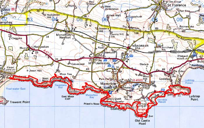
 FRESHWATER EAST TO LYDSTEP COASTAL STRIP
GRID REFERENCE: SS 061974
AREA IN HECTARES: 143
Historic Background
A character area of modern Pembrokeshire comprising a narrow coastal strip between Freshwater East and Lydstep. Historically, this coastal strip has always been marginal land, lying between cultivated land and the sea-cliffs. However, there is evidence for prehistoric occupation within the area in the form of flintworking floors and burnt mounds, and two iron age promontory forts. The high-visibility of the cliffs attracted monument-building, with a neolithic chambered tomb near Manorbier. The place-name elements Skrinkle and Skomar indicate that the area was known – and perhaps even settled – by Scandinavian seafarers during the early medieval period. Within the historic period, land-use was mainly as rough grazing. During the medieval period, the area lay within the Anglo-Norman manor of Manorbier (and Penally) which was a mesne lordship or honorial barony held, by the service of 5 knights, of the Lordship and Earldom of Pembroke, a heavily Anglicised region that was brought under Anglo-Norman control before 1100, re-organised along English manorial lines and never retaken by the Welsh. The barony had been held, since the very early 12th century, by the de Barris and, on their extinction in 1392, was sold to the Dukes of Exeter before reverting to the crown in 1461. From that point onwards it was leased to a succession of individuals before being settled on the Philippses of Picton Castle, with whom it remained until the 20th century. The area was recorded in some detail in three later surveys of the Manor of Manorbier, in 1601, 1609 and 1618. Five tenants possessed sheepcotes, associated with holdings variously recorded as furze, heath, ‘moorish ground’ and ‘cliff ground’. The animals were presumably grazed on the unenclosed coastal strip within this character area. The name ‘Conigar Pit’ on Old Castle Head indicates a former rabbit-warren. There are only a few places suitable for landing small boats and the suggestion by Gerald of Wales (‘Giraldus Cambrensis’) that Manorbier Bay might become ‘a most excellent harbour for shipping’ was never realised. Apart from agriculture, other past activities within this area have included quarrying. In 1867, part of the cliff top at East Moor was assigned for a fort, which was never constructed. The site was later used for a World War 2 light anti-aircraft gun firing pad. No trace of this now survives and the land has reverted to moor. The present Manorbier Camp was established, on Old Castle Head, as an anti-aircraft artillery school during World War 2. It was formerly more extensive than today and a number of installations survive within this coastal strip. An anti-aircraft development unit was also established at Lydstep Point. Modern activity within the area is mainly associated with tourism and leisure – the Pembrokeshire Coast Path runs through the area, and there is a Youth Hostel and picnic site at Skrinkle.
Description and essential historic landscape components
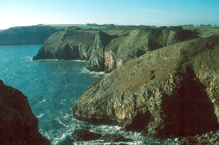
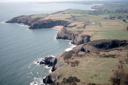
This area consists of high, exposed sea cliffs, a narrow bank cliff top and small sandy bays running from Freshwater East in the west to Lydstep Point in the east, a total of about 9km. It is a very narrow strip, sometimes less than 50m, but opening out to 300m wide at Lydstep Point, and with an average width of about 100m. The Pembrokeshire Coast Path runs along the top of the cliffs, and visitor car parks are located at Skrinkle and Lydstep Point. There are no inhabited buildings, although several structures associated with a mid 20th century anti-aircraft artillery school – observations posts, gun emplacements – lie between Old Castle Head and Lydstep Point. Other archaeological sites include prehistoric burnt mounds – possible settlement sites – flint working floors, the King’s Quoit chambered tomb and two iron age promontory forts. The last three sites are important historic landscape components. Old coastal quarries are also recorded, including large limestone quarries with quays and wharfs at the extreme eastern end of this area at Lydstep Haven.
This is a very distinctive historic landscape character area, bounded by the open sea to the south and enclosed farmland to the north.
Sources: Charles 1992; Hodgeston Parish tithe map 1840;
King and Perks 1970; Manorbier Parish tithe map 1842; National Library
of Wales NLW Vol 88; Pembrokeshire Record Office HPR/57/31; Thomas 1994;
Thorpe 1978; Walker 1992
Base map reproduced from the OS map with the permission
of Ordnance Survey on behalf of The Controller of Her Majesty's Stationery
Office, © Crown Copyright 2001.
All rights reserved. Unauthorised reproduction infringes Crown Copyright
and may lead to prosecution or civil proceedings. Licence Number: GD272221