Home > Historic Landscape Characterisation > Milford Haven Area > |

PEMBROKE 
GRID REFERENCE: SM 986015
AREA IN HECTARES: 288
Historic Background
Pembroke is located on an elongated Carboniferous Limestone promontory
at the head of one of the many creeks of the Milford Haven waterway. There
is no hard evidence to suggest a settlement on the site prior to the foundation
of the Norman Castle and town, but the discovery of Roman coins in the
1880s indicates a Roman presence in the area. Also, the manner in which
Roger de Montgomery made straight for Pembroke in 1093 to found his castle
implies the presence of a pre-Norman Welsh administrative centre on the
site. Pembroke’s town charter was granted before 1135. However,
it is likely that a settlement had begun to form near to the castle from
1093. A mint was present by 1130. The town prospered and grew rapidly.
Two churches lay within the circuit of the town walls with Monkton Priory
outside to the south. By the 16th century the town was in decline. Although
the county town following the creation of Pembrokeshire in 1536, Pembroke’s
role seems mainly to have been titular with many of the functions taken
by Haverfordwest. However, a customs house was established at Pembroke
in 1599 following reorganisation of maritime legislation, although few
vessels were registered to the town. It seems to have functioned more
as a merchant seat than as a dock. Donovan, writing in 1806, expressed
the hope that the port of Pembroke ‘might one day rise to consideration’.
The growth of Milford Haven, Pembroke Dock and Neyland dashed these hopes.
Even so, sailing ships occasionally called at Pembroke’s quay, the
last being ‘Kathleen & May’ which made regular visits
to the North Quay down until the 1960s. Constructions such as bridges,
dams, mills and quays were undertaken at various times in the history
of Pembroke. A bridge was mentioned in the town charter - this is taken
to be a reference to the north bridge. A mill is first mentioned in 1199.
It is considered that this mill stood close to the north bridge. By 1678,
the mill was a substantial stone-built tidal corn-mill, with the bridge
acting as a dam for the mill-pond. This mill continued to function until
after World War 2, but it burnt down in 1956, and its remains were demolished
in 1968. A second mill, mentioned in 14th century accounts lay to the
south side of the castle. The railway came to Pembroke in 1863, when a
station was opened east of the town, within one of the early suburbs shown
on Speed’s map of 1611.
Included in this area is the core of the former Bush estate on the northern bank of the Pembroke River, now a secondary school and residential home. A house and gardens had been established here by 1772, when they were depicted on an estate map. 19th century estate maps show a similar pattern.
Apart from houses and other buildings close to the bridge, very little development had taken place prior to the 20th century on the northern bank of the Pembroke River opposite the town. Early 19th century estate maps show a landscape of regular fields and farms. A similar position pertained to the south and east of the medieval town. It is in these three areas – the northern side of the Pembroke River, the north-facing slopes to the south of the town and those to the east of the town – that housing development, including council and private estates, has occurred. Housing to the west of Monkton is included in Pembroke historic landscape character area. Morphologically this is similar to 20th century development, but an examination of 19th century maps shows that between 1841 and 1859 a grid pattern of house plots was laid out that still survives. By 1859, houses had been constructed on many of the plots and others were ready for development.
Base map reproduced from the OS map with the permission
of Ordnance Survey on behalf of The Controller of Her Majesty's Stationery
Office, © Crown Copyright 2001.
All rights reserved. Unauthorised reproduction infringes Crown Copyright
and may lead to prosecution or civil proceedings. Licence Number: GD272221
Description and essential historic landscape components
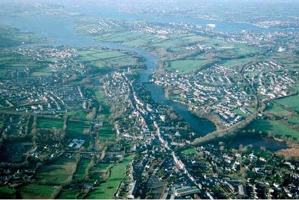
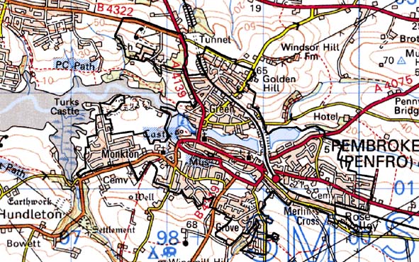
This is an urban area and consists of the centre of Pembroke together
with neighbouring built-up areas such as Monkton and Kingsbridge. The
historic core of Pembroke is constructed on a low, east-west aligned,
limestone ridge, to the north and west of which lies the tidal (but now
dammed) Pembroke River and to the south an area of marshy land (now partly
reclaimed and under car parks). Pembroke Castle on the western end of
this ridge dominates the whole of the town that developed in stages eastwards
from the castle, along one long main street, and possibly received two
lines of defences prior to the construction of the present walls in the
early 14th century. The remains of the walls still encircle the historic
core of the town, which includes two medieval parish churches, St Mary’s,
and St Michael’s. St Michael’s developed as an extra-mural
parish church (and market) beyond an earlier phase of town defences. Essentially
the historic core comprises the long street flanked by shops, businesses
and houses constructed in medieval burgage plots. Many of the buildings
date to the late 18th century or early 19th century and consist of two
and three storey structures built in the Georgian tradition. These account
for most of the 103 listed buildings in the town. There are, however,
both earlier and later houses and structures present, including some late-medieval
vaulted cellars and a row of 17th century town houses on Westgate Hill.
Quays with some stone-built warehouses situated to the north of the castle
date to the 19th century. Southwest of the castle Monkton medieval church
provides a secondary focus for the settlement. Houses here mostly date
to the 19th century and 20th century. To the west of Monkton village is
a large 20th century council housing estate. A tide mill formerly stood
on the bridge over the Pembroke River. Apart from warehouses and quays
very little development occurred the north of the river until the 20th
century. Large housing estates now lie here, and a secondary school and
sports centre have been constructed on part of the old Bush estate. 19th
century housing also lies to the east of the town, including a terrace
of single storey cottages. Further out to the east and south are extensive
20th century housing estates.
Pembroke is a very distinctive historic landscape character area and contrasts with neighbouring farmland. To the northwest, the fringes of the town are separated from Pembroke Dock’s housing estates by just a few fields. Within a few years these two towns will form a single small conurbation.
Sources: Boon 1986; Carradice 1992; Lilley 1995; Ludlow 1991; Ludlow 1993; Price 1986; Soulsby 1983; Monkton Tithe Map 1841; St Mary Pembroke Tithe Map 1841; St Michael Tithe Map 1841; PRO D/ANGLE/115; PRO/D/BUSH/6/26; PRO D/BUSH/6/27; PRO D/BUSH/6/144; PRO D/BUSH/6/145