Home > Historic Landscape Characterisation > Milford Haven Area > |


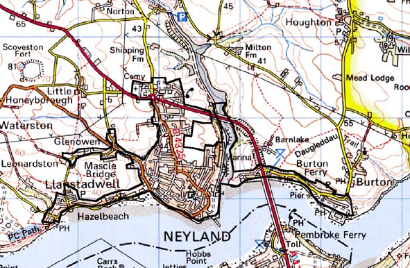
NEYLAND 
GRID REFERENCE: SM 964056
AREA IN HECTARES: 181
Historic Background
This area lies on the north shore of the Milford Haven waterway and mainly
comprises the small town of Neyland. The area is divided between the ecclesiastical
parishes of Burton, and Llanstadwell whose parish church, mentioned in
the 12th century and possibly of an earlier foundation, lies at the western
edge of the area on the shore of the waterway. There is no recorded historic
settlement around the church at Llanstadwell. However, a small settlement
probably developed at Burton Ferry, at the eastern edge of this area,
in the late medieval period to serve the ferry crossing to the south of
the waterway. A bridge did not replace this ferry across the Haven until
1975. Burton Ferry occupied a detached portion of the Lordship of Pembroke.
However, the majority of this character lay within the medieval Manor
of Honeyborough. This comprised one knight’s fee directly held of
the Earls of Pembroke as their share of the Lordship of Haverford, and
2½ carucates held of the Barony of Walwyn’s Castle ‘by
homage’. Great Honeyborough farm represents the manorial centre.
In c.1600 the manor was shared between the Perrot, Bowen and Scourfield
families, who were succeeded by the Batemans and the Taskers. After 1810
it was held by farming tenants. Neyland itself is of no antiquity. George
Owen included ‘Nailand’ in his list of creeks in 1596, but
there was no contemporary settlement. The present town lies across what
were the village and fields of Great Honeyborough (‘Townred of Honeyboro’
on 18th century maps). This was an entirely agricultural community with
an open-field or strip field system still in operation in the 18th century,
although estate maps of 1759 and 1773 show that some of the strips were
beginning to be enclosed by hedges.
Between 1751 and 1782 Neyland had become one of the largest herring ports
in Wales, and in c. 1760 the Admiralty chose the site for the construction
of their ships. Two ships were built in privately owned yards: the Prince
of Wales in 1760 and the Triumph in 1784. Two forts were originally planned
to defend these yards, but only a small water-line gun fort was constructed,
and after spending £20,000 on the project the government withdrew
their support. The dockyards continued in use building civilian ships,
and further yards were opened later in the 18th century and in the 19th
century. In the 19th century an average of two ships a decade were built
at Neyland. Modest port facilities were also located here; a salt refining
works was in operation in 1797 and imports of sugar and wool are reported
in 1811. Estate maps of the late 18th century show that development was
still small-scale, with just a handful of houses and other buildings on
the east and west banks of Barnwell Pill. The opening of GWR’s terminus
at Neyland in 1856 marked the real beginning of the town. Old facilities
were swept away and the population rapidly increased. A fixed pier constructed
for an Irish ferry service was extended in 1857 when a second boat was
added. Cattle stages, gasworks and a hotel were also constructed. Development
of the port was constrained by objections from the Admiralty who feared
that further piers and other installations would interfere with ships
launched from Pembroke Dock. Transference of the Irish ferry service to
Fishguard in 1906 led to Neyland reinventing itself as a fishing port:
an ice factory and fish market were opened in 1908. By the 1920s this
industry had gone into decline and Neyland was becoming a backwater; a
process hastened by the closure of the railway in 1964 and of the ferry
service to Hobbs Point in 1975, although the opening of a marina in Barnwell
Pill and an industrial estate on the northern fringe of the town have
provided employment. The town of Neyland spread in conjunction with the
growth of industry, first with housing development close to the shore
line on both sides of Barnwell Pill, and in the 20th century with schools,
dwellings and other developments on the gentle slopes to the north of
the Milford Haven waterway.
Base map reproduced from the OS map with the permission
of Ordnance Survey on behalf of The Controller of Her Majesty's Stationery
Office, © Crown Copyright 2001.
All rights reserved. Unauthorised reproduction infringes Crown Copyright
and may lead to prosecution or civil proceedings. Licence Number: GD272221
Description and essential historic landscape components
Neyland is an urban historic landscape area. The oldest parts of this
area comprise Great Honeyborough and settlements along the bank of the
Milford Haven waterway at Hazelbeach, Llanstadwell, Neyland and Burton
Ferry. Included is the medieval church of St Tudwal at Llanstadwell and
the neighbouring Georgian house. The settlement along the shore is linear
in character and consists mainly of mid 19th century and late 20th century
houses. The main element of this area is Neyland itself. Its focus is
the old railway terminus and the docks. Both of these have closed and
little survives to indicate the former location of the terminus as a small
industrial estate has been constructed over it. Barnwell Pill has been
converted to a marina and is overlooked by modern housing constructed
on the course of the old railway. Sections of the old quays and the remains
of an 18th century waterline gun fort survive. Buildings close to quay
and waterway date to the mid 19th century. Uphill of the quay and waterway,
Neyland has developed organically, with no obvious traces of planning.
Terraced, two storey houses comprise the main, 19th century housing type.
These are generally cement rendered, probably stone-built, with slate
roofs. Late 20th century housing in a variety of styles and materials
fringes Neyland. Indeed modern development has encircled the former agricultural
village of Great Honeyborough joining it in one settlement with Neyland.
However, the village morphology at Great Honeyborough is preserved and
buildings, including 19th century vernacular cottages and houses and an
18th century house with massive chimney, survive. Modern housing developments
fringe the settlements along the waterway. Modern light industrial and
commercial properties have been established on the edge of Neyland, in
particular on or close to the main, modern road to the Cleddau Bridge.
Archaeology is not a strong component of this area.
Neyland is a distinctive historic landscape area and contrasts with the neighbouring areas of dispersed farms and fields.
Sources: Jones 1996; Mason 1986; McKay n.d.; Owen 1897; Owen 1911; Owen
1918; Peters 1905; Rees 1957; Llanstadwell Third Part Tithe Map 1830;
NLW PICTON CASTLE VOL 1; NLW MORGAN RICHARDSON DEPOSIT No. 1