Home > Historic Landscape Characterisation > Milford Haven Area > |

HAVERFORDWEST 
GRID REFERENCE: SM 947159
AREA IN HECTARES: 580
Historic Background
Haverfordwest is the county town of Pembrokeshire and was one of the largest
towns in medieval Wales. There is no archaeological evidence for any activity
on the site of the town prior to the Anglo-Norman conquest and the establishment
of the castle by ‘Tancred the Fleming’ in 1100-1110. The town
and castle occupy the lowest bridging point of the Western Cleddau, the
strategic and economic value of which were factors in the choice of site
and its subsequent development. The castle became the centre of an Anglo-Norman
lordship, Rhos or Haverford, which nominally, at least, was a member of
the Earldom of Pembroke. Around the castle developed a small settlement,
known as the ‘Castleton’, which contained the parish church
of St Martin and was eventually walled, but there is no record of a charter
until 1207 when the town had already developed to a considerable size.
The charter granted market and fair privileges to the lord Robert FitzTancred,
and there is evidence that cloth manufacture was undertaken during this
early period, in addition to mercantile activity at the town quay. An
Augustininan priory had been founded before 1210, had had the additional
parish churches of St Mary and St Thomas. The church at Prendergast, though
not lying within the medieval borough, is earlier, having been established
during the early 12th century. By 1300, the town was of a considerable
size, with over 300 burgages (larger than any of the castle-boroughs of
North Wales), an additional marketplace at St Mary’s and settlements
both here and around St Thomas’s. There is no evidence, however,
that this development was ever enclosed within town walls. An indication
of the town’s importance is that it lies at the nodal point of 13
route-ways. Haverfordwest declined after the Black Death in the mid-14th
century and areas of settlement were abandoned. However, it was granted
a charter of incorporation in 1479, and during the 16th century took over
the role of county town from Pembroke. The castle which was ‘utterly
decayed’ became the county gaol. It was rebuilt in 1866 but closed
in 1878. By the mid 16th century Haverfordwest could be described as ‘the
best built, the most civil and quickest occupied town in South Wales’.
Further expansion was checked by plague which, in the mid 17th century,
claimed a fifth of the population. The silting of the river, and the establishment
of a port at Milford Haven in the 1790s, signalled the end of its role
as a port. However, its status as county town and as a local market centre
has continued, assisted by its incorporation into the railway network
in 1854. The greatest expansion of Haverfordwest has occurred during the
20th century with the establishment of sizeable suburbs at Merlin’s
Bridge, Albert Town, around the railway station and the earlier church
at Prendergast.
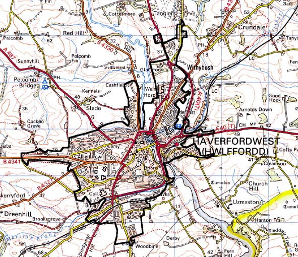
Base map reproduced from the OS map with the permission
of Ordnance Survey on behalf of The Controller of Her Majesty's Stationery
Office, © Crown Copyright 2001.
All rights reserved. Unauthorised reproduction infringes Crown Copyright
and may lead to prosecution or civil proceedings. Licence Number: GD272221
Description and essential historic landscape components
Th core of the town retains many of its historic components, notably its
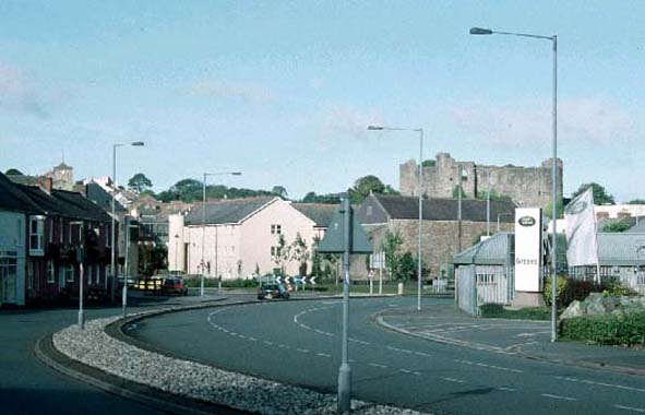
street-plan, burgage-plots and churches. The castle, established on a
bluff overlooking the west bank of the Cleddau., also survives. The initial
walled settlement or ‘Castleton’ lies immediately west and
north of the castle, around the church of St Martin, within which is an
informal arrangement of streets. However, neither the town wall nor gates
survive. The main town bridge was, until the construction of New Bridge
in 1835, located 200 metres upstream of the present structure. The church
of St Mary was established within a triangular marketplace, separated
from ‘the Castleton’ by the steep valley of a now-culverted
stream called ‘Shitters’ Brook’, giving an indication
of its original function. A semi-grid pattern of streets leads west and
south from St Mary’s. Within one of these ‘grids’ lies
St Thomas’ church, but there is no evidence that St Thomas Green
was originally an open space. The priory ruins lie on the west bank of
the Cleddau immediately south of the town, while the Dominican Friary
established in 1256 on a more cramped site between the castle and the
river has gone. Post-medieval rebuilding within the town includes 18th
century and 19th-century buildings with town houses in the Georgian tradition.
These can be of good quality and there are 245 listed buildings within
the historic town. The castle and 19th century county gaol buildings,
and a number of warehouses associated with the former quay, also survive.
Subsequent development is post-medieval and suburban in nature, and most
of it is late. Albert Town and Prendergast comprise mostly 19th century
terraces, with later schools and sports grounds at Albert Town. Merlin’s
Bridge is a council estate established after World War 2, divided from
the town by a green space either side of Merlin’s Brook, through
which runs the railway line and the A40 Haverfordwest bypass. Other 20th
century developments include the hospital to the north of the town, the
late 20th century county hall next to the priory ruins, and some limited
alterations to the road system within the historic town.
Haverfordwest is a very distinctive historic landscape character area and contrasts with neighbouring farmland.
Sources:
Charles 1967; James 1981; Ludlow 1998; Miles 1999; Soulsby 1983;