Home > Historic Landscape Characterisation > Milford Haven Area > |

TEXACO OIL REFINERY AND BP JETTY 
GRID REFERENCE: SM 905030
AREA IN HECTARES: 237
Historic Background
Apart from Fort Popton and a narrow strip of sea cliff/cliff top this
entire area comprises an oil refinery and oil pumping station. It occupies
part of Rhoscrowther parish, which represented the medieval Manor of Popton,
and the west half of Pwllcrochan parish. This comprised half a knight’s
fee held directly of the Lordship of Pembroke. It had an annual value
of 10 marks in 1324 after it had been acquired, from the Popton family,
by the Perrots who later rose to great prominence in southwest Wales.
Eastington, which lies south of this area, is a large, semi-fortified
hall-house built by the Perrots in the late 14th century. The Meares acquired
the manor in the 17th century. Prior to the construction of oil industry
installations the landscape consisted of farms and regularly shaped fields
– little change had occurred to this agricultural landscape since
the early 19th century – with a fort situated on the cliff tops.
This fort, Fort Popton, was built 1859-64 to act in conjunction with Fort
Hubberston on the opposite shore of the Milford Haven waterway. It comprised
a casemated battery of 31 guns and included a defended barracks with accommodation
for 10 officers and 240 men. It was redesigned in 1900. In 1961, BP constructed
a jetty below the fort and a pumping installation within and close to
the fort in order to pump oil to Llandarcy, near Swansea. The pumping
station closed in 1985. The Field Studies Council now uses part of the
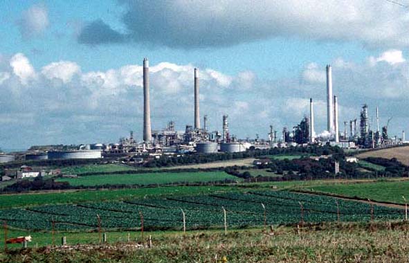
fort as a research centre. To the east of the fort Texaco constructed
an oil refinery in 1963. It opened in 1964.
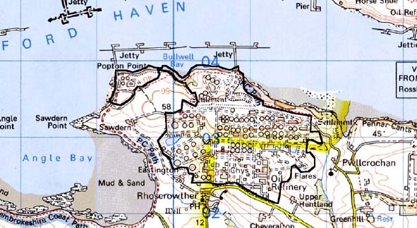
Base map reproduced from the OS map with the permission
of Ordnance Survey on behalf of The Controller of Her Majesty's Stationery
Office, © Crown Copyright 2001.
All rights reserved. Unauthorised reproduction infringes Crown Copyright
and may lead to prosecution or civil proceedings. Licence Number: GD272221
Description and essential historic landscape components
Most of this historic landscape character area consists of the massive
industrial complex of the Texaco oil refinery and the decommissioned BP
jetty and oil storage tanks, but it also includes Fort Popton which was
altered to accommodate part of BP’s pumping installation, a small
amount of farmland, steep wooded coastal slopes below the refinery and
mooring jetties. It lies
on an undulating plateau at approximately 50m above sea level on the south
side of the Milford Haven waterway.
This is a distinct historic landscape character area and contrasts with neighbouring farmland.
Sources: Mckay 1993; Pwllchrochan Parish Tithe Map 1840; Rhoscrowther
Parish Tithe Map 1838; PRO D/ANGLE/5; PRO D/ANGLE/92; PRO HDX/198/2; Saunders
1964; Smith 1988