Home > Historic Landscape Characterisation > Milford Haven Area > |

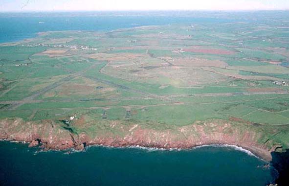
DALE AIRFIELD 
GRID REFERENCE: SM 796067
AREA IN HECTARES: 173
Historic Background
High sea cliffs border this historic landscape character area to the west
and southwest. Apart from these and a farm known as The Hookses, the remains
of a World War 2 airfield comprise the entire area. This area lies almost
entirely within the parish of Dale, which is more-or-less coterminous
with the medieval Manor of Dale. This formed a subordinate, mesne lordship
of the barony of Walwyn’s Castle, assessed as one knight’s
fee, with a caput probably in the vicinity of the present village. The
manor had, by the 13th century at least, been acquired by the de Vale
dynasty and in 1307 ‘The heirs of Robert de Vale hold one knight’s
fee at Dale containing 10 carucates’. North of the village, and
within this character area, lay commons on which the tenants preserved
the right of depasturing cattle, after the lord of the manor had cleared
off the hay, into the 19th century. Henry VII apparently granted this
privilege. Dalehill Farm partly underlies the airfield and is probably
to be associated with the ‘Hill’ (or ‘Le Hull’),
where Robert de Vale ‘and his ancestors’ held their manorial
tenant’s court. Robert de Vale died c. 1300 and the manor of Dale
was divided between his daughters as co-heiresses. It found its way into
the hands of the Walter family of Rosemarket who continued to hold Dale
until the late 17th century when it passed to the Allens of Gelliswick,
and then to the Lloyd-Philipps family who still possess Dale Castle. The
Hookses farm was first recorded in 1713. Prior to construction of the
airfield the landscape was entirely agricultural consisting of farms –
West Point, Longlands and Hooks Vale (only Hooks Vale – now the
Hookses – survives) - with small linear fields and/or small irregular
fields. These fields were the enclosed strips of an open- or strip-field
system. Similar fields can still be seen to the east of the airfield.
The airfield opened in 1942. Wellington bombers operated from Dale. Their
mission was to attack submarines in the Atlantic as well as their ports.
Because of its relative remoteness Dale became a training centre as well
as a research and development centre. The Coastal Command Development
Unit was based at Dale and Angle. Dale airfield closed within five years
of the cessation of hostilities.
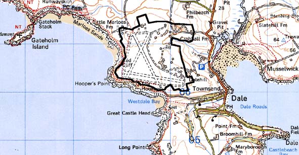
Base map reproduced from the OS map with the permission
of Ordnance Survey on behalf of The Controller of Her Majesty's Stationery
Office, © Crown Copyright 2001.
All rights reserved. Unauthorised reproduction infringes Crown Copyright
and may lead to prosecution or civil proceedings. Licence Number: GD272221
Description and essential historic landscape components
This historic landscape character area is covered by the remains of the
World War 2 airfield. The runways and perimeter roads remain, albeit overgrown,
and many of the accommodation buildings survive, although in a derelict
state. Apart from the creation of rough boundary banks from bulldozed
rubble very little land restoration has been undertaken. The areas between
the concrete runways and roads are given over to rough grazing and are
divided by wire fences. The only inhabited building is the Hookses farmhouse,
which is unlisted and tucked away in a hollow on the cliff tops.
This is a very well defined historic landscape area as it is bounded either by farmland or by sea-cliffs.
Sources: Air Ministry Plans D-21, D-21a; Calendar of Charter Rolls 2;
Charles 1992; Dale Parish Tithe Map 1847; Ludlow, in Crane forthcoming;
Ordnance Survey 6” to 1 mile 1st Ed XXXII, 1887; Owen 1911; Owen
1918