Home > Historic Landscape Characterisation > Milford Haven Area > |

SCOVESTON - BURTON 
GRID REFERENCE: SM 926082
AREA IN HECTARES: 2550
Historic Background
A large character area lying the north of the Milford Haven waterway,
within the ecclesiastical parishes of Llangwm, Llanstadwell, Rosemarket
and Steynton. Much of the area formed part of the medieval Manor of Pill,
part of the larger Manor (or Sublordship) of Pill and Roch, which was
created under the de Roches between 1100 and 1130. Its relationship with
the Lordship of Haverford, of which it was notionally a member, was always
a matter of dispute. Pill was a large and important manor with a caput
at the head of Castle Pill (pill is a local term for a tidal inlet) at
the west end of the area – possibly on the site of an iron age hillfort
and later a Civil War defence. The southeast end of this area lies within
the parish of Burton, which represented a detached portion of the Lordship
of Pembroke. Burton parish church was present by 1291. The Manor (and
parish) of Llangwm, to the north, was a holding of the de Vales until
a Roche kinsman, Gilbert de la Roche, acquired it in the late 13th century.
The Roches granted ‘six bovates of land in Studdolph, and five acres
of land with half a carucate of land in the same township’ to the
Tironian Pill Priory in its late 12th century foundation charter. Hayston
was present in the 14th century. The present settlement pattern appears
to be of relatively late origin as only a few of today’s farms and
landholdings can be identified with medieval manors and townships. Scoveston
is not recorded until the mid 15th century, while the remainder –
Jordanston, Norton, Milton, Westfield etc – were not recorded until
the 16th- and 17th-centuries. Some, such as Oxland, are 18th century in
origin. Nevertheless, these different periods of origin are not reflected
in any differing tenurial arrangements, and a homogenous pattern of enclosure
has resulted. By the time of the first estate maps in the late 18th century
and the tithe survey in the 1840s the landscape of today had been established.
There are hints that at least parts of the area had evolved from open
field systems. For instance, enclosed strip fields are shown on estate
maps on the east side of Castle Pill and close to the very small village
of Burton. No traces of these strips now remain. The area has remained
primarily agricultural but its military potential has long been apparent.
Castle Pill was fortified by Royalist forces in 1643, with an 18 gun fort
garrisoned by 300 men. The massive inland Scoveston Fort was the only
defensive work to be constructed after the 1860 Royal Commission report
on defence proposed a ring of forts around the Milford Haven waterway
to prevent it from landward attack. Railways also crossed the area, to
Neyland in 1856 and Milford Haven in 1859.
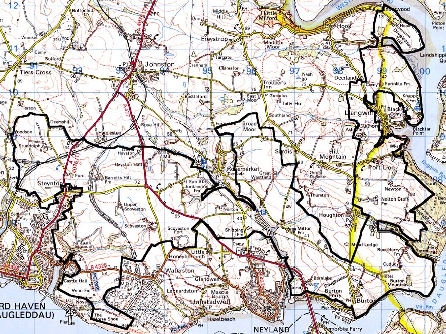
Base map reproduced from the OS map with the permission
of Ordnance Survey on behalf of The Controller of Her Majesty's Stationery
Office, © Crown Copyright 2001.
All rights reserved. Unauthorised reproduction infringes Crown Copyright
and may lead to prosecution or civil proceedings. Licence Number: GD272221
Description and essential historic landscape components
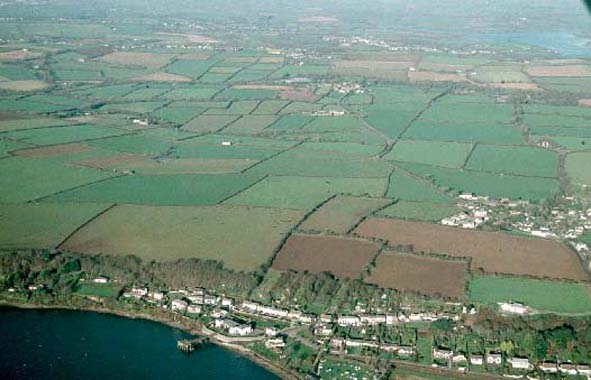
This very extensive historic landscape character area extends from the
town of Milford Haven in the west, along the northern shore of the waterway
past Neyland and up to and past the village of Llangwm. Despite its size
it is a remarkably coherent landscape consisting of large farms, dispersed
houses and large, regular fields. Although it lies close to Milford Haven
waterway, this area only directly borders the sea at a few locations near
Burton and Llangwm. Pasture is the dominant land-use, with a little arable
land particularly in the western part of the area. There is virtually
no rough or waste ground. Apart from deciduous trees on steep valley sides,
such as at Castle Pill and Barnwell Pill, in some sheltered hollows, and
on the banks of the Milford Haven waterway, this is not a landscape characterised
by woodland. Occasional trees are also present in some hedgerows. Earth
banks topped with hedges are the main boundary type. Hedges are generally
well-maintained, although in the northern part of the area some are becoming
overgrown and a few are derelict. Burton Mountain and Williamston Mountain,
once one of the few open areas on the Milford Haven waterway is divided
into large fields by banks and hedges. Apart from Burton village the settlement
pattern is one of dispersed farms and houses. There are several mansions
and large farms within this area, including Jordanston Farm, Williamston,
East Hook and Studdolph Hall. Some of these houses are of some antiquity,
such as East Hook, a 17th century and 18th century house next to the ruins
of a 16th century house, and others indicate the minor gentry origins
of the larger farms, such as the three storey Georgian house of Jordanston.
Some of the larger houses, Castle Hall for example, have been demolished.
Attached to most of these large houses are ranges of stone-built, 19th
century, and sometimes earlier, outbuildings, often arranged around a
courtyard, and sometimes set some distance from the dwelling. The wide
range of buildings at Castle Hall Farm are a good example of this type.
Gardens and parkland survive at some of these larger houses. Interspersed
across the landscape are smaller farms. The houses take a variety of forms,
but in the main they date to the 19th century, and are stone-built, rendered,
slate-roofed, and broadly in the Georgian tradition. Many have been modernised.
Older farmhouses and modern farmhouses are also present, presumably replacements
of earlier structures. Old outbuildings are also stone-built, but usually
of just one or two ranges. Most farms of this size have large ranges of
modern steel and concrete outbuildings. Dispersed modern houses are present
in this area, but are not a defining characteristic, apart from west and
north of Jordanston. Here mid 20th century semi-detached houses in a fairly
dense scatter are a distinct feature of the landscape. At Burton, the
only village within this area, the medieval parish church of St Mary together
with a cluster of late 18th century and 19th century dwellings is surrounded
by late 20th century housing, including a small estate. Other buildings
include the massive remains of Scoveston Fort, an element of the mid 19th
century military defence of the Milford Haven waterway. Given the large
extent of this area it is not surprising that there are a large number
and variety of archaeological sites. However, these do not greatly characterise
the landscape. Of interest are: several prehistoric funerary and ritual
sites, including standing stones, chambered tombs and round barrows, an
iron age fort with the slight remains of a Civil War fort, several prehistoric
find spots, medieval mill and windmill sites, and World War 2 defensive
features.
To the south and east the boundary of this area is very well-defined against the Milford Haven waterway, the town of Milford Haven, the town of Neyland, an Oil Refinery and a large tract of woodland. On other sides this area is very difficult to define, and any boundary should be considered a zone of change rather than hard-edged.
Sources: Burton Parish tithe map 1840; Charles 1992; Jones 1996; Llangwm
Parish tithe map 1841; Llanstadwell Parish tithe map 1849, Llanstadwell
Third Part tithe map 1830; Ludlow 2002; NLW PICTON CASTLE VOL 1; NLW R
.K. LUCAS NO. 17, 19 & 25; Page 2001; Price 1986; Pritchard 1907;
PRO D/RKL/1194/4; PRO RKL/841; Rees 1975; Rosemarket Parish tithe map
1843; Saunders 1964; Stainton Parish tithe map 1843