Home > Historic Landscape Characterisation > Milford Haven Area > |

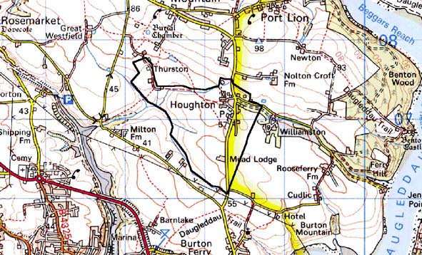
HOUGHTON 
GRID REFERENCE: SM 978069
AREA IN HECTARES: 122
Historic Background
A small character area lying within the ecclesiastical parish of Burton,
which is coterminous with a detached portion of the medieval Lordship
of Pembroke, comprising a distinct pattern of long, narrow fields to the
southeast of the linear settlement of Houghton. The first large-scale
maps of Houghton – estate maps of the 1770s and the tithe map of
1840 – depict a coherent landscape unit that was, however, undergoing
change. The estate maps depict the hamlet or ‘township’ of
Houghton, which was a linear settlement of about 10 dwellings in 1777,
with its surrounding open field system, whose extent is the same as this
character area. By the late 18th century a number of the strips of the
open field system had been enclosed into long narrow fields, a process
that was complete by 1840. The open field landscape appears to have been
a late-medieval or even early post-medieval creation – the name
‘Houghton’ was not recorded until 1541 - and the area occupies
a distinct pocket suggesting that it may have been created from earlier
common land. It lies, moreover, at the highest point within the parish
of Burton, and evidence for past common land-use may be preserved in the
farm-name ‘Houghton Moor’. Alternatively, the open field system
may have been superimposed upon an earlier pattern, and the ‘moor’
element may have been confined to the marshy ground alongside the stream
that runs through the area. The name ‘Thurston’ was recorded
in 1376 and possibly refers to Lower Thurston Farm, but again is more
likely to represent Upper Thurston to the east of the area. A third farm,
Mead Lodge, was first recorded in 1841. The enclosed strip-fields survive,
but in a degraded state.
Base map reproduced from the OS map with the permission
of Ordnance Survey on behalf of The Controller of Her Majesty's Stationery
Office, © Crown Copyright 2001.
All rights reserved. Unauthorised reproduction infringes Crown Copyright
and may lead to prosecution or civil proceedings. Licence Number: GD272221
Description and essential historic landscape components
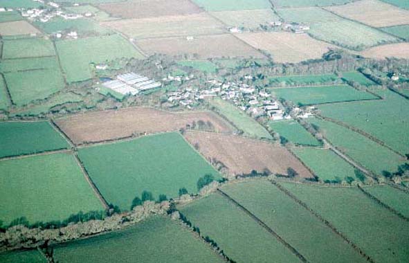
Houghton historic landscape character area is centred on the village of
Houghton - a loosely clustered settlement along either side of a B road.
– set in undulating farmland at about 65m above sea level. Houses
in the village are either 19th century in date, mostly two storeys and
in the vernacular style, although many have been recently modernised,
or are late 20th century in a variety of styles and materials. !9th century
lodges to larger houses are located in this area. Currently there is considerable
building work taking place in the village. There is a small primary school
here. The landscape surrounding the village is one of small fields. Long
strip-shaped fields are present, but the majority are now fairly regular
in shape and approximate to a rectangle. Boundaries are banks topped with
hedges. The hedges are generally in a good state of maintenance, but some
are overgrown and support small trees. Distinctive hedgerow trees and
woodlands are not defining characteristics of this area. Land-use is almost
entirely pasture. The few archaeological sites in this area include a
bronze age burnt mound and two possible holy well sites. There are no
listed buildings.
Historically Houghton is a very well defined historic character area. However erosion of some of the landscape components in recent years has blurred the distinction between this area and its neighbours, and there is now no hard-edged boundary on any side of Houghton character area.
Sources: Burton Parish tithe map 1840; Charles 1992; NLW PICTON CASTLE
VOL 1; PRO D/EE/7/338;
Base map reproduced from the OS map with the permission
of Ordnance Survey on behalf of The Controller of Her Majesty's Stationery
Office, © Crown Copyright 2001.
All rights reserved. Unauthorised reproduction infringes Crown Copyright
and may lead to prosecution or civil proceedings. Licence Number: GD272221