Home > Historic Landscape Characterisation > Milford Haven Area > |

HOOK 
GRID REFERENCE: SM 970111
AREA IN HECTARES: 291
Historic Background
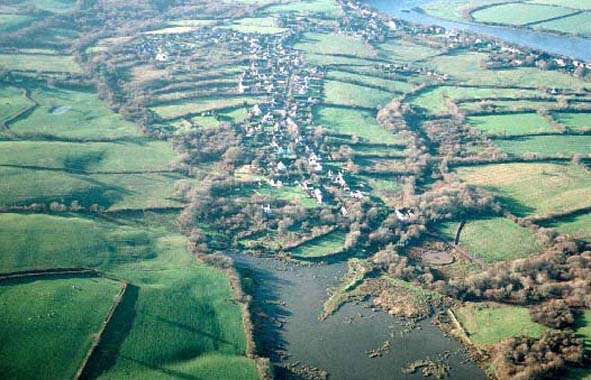
A small character area occupying the upper reaches of the Milford Haven
waterway, within the parishes of Freystrop and Llangwm. The latter parish,
probably coterminous with the medieval mesne lordship of Llangwm, was
a holding of the de Vales until a Roche kinsman, Gilbert de la Roche,
acquired it in the late 13th century. Its relationship with the Lordship
of Haverford, within which it lay, was always a matter of dispute. Freystrop
was a member of the Lordship of Haverford. Its manorial centre probably
lay in the vicinity of Lower Freystrop, the modern settlement of Freystrop
being largely a 20th century nucleation around a cross-roads. Indeed,
the general settlement pattern in this area appears to be of relatively
late origin. This character area, which was primarily agricultural until
the 19th century, comprises three distinct units. A system of long narrow
fields lies to the east of Hook. These have the appearance of an enclosed
medieval open field, but the name ‘Hook’ is not recorded until
1601, and therefore they might be more recent. To the north and south
of this system are larger, more regular enclosures, possibly of later
origin, around the hamlets Underwood and Deerland. These two settlements
are not recorded until the 19th century. The third unit occupies the bulk
of the area, and is a pattern more irregular fields associated with the
19th century farmstead of Maddox Moor. This farm may have been established
over former woodland – Hook Wood was included within George Owen’s
list of the greater woods of Pembrokeshire in c.1601. Evidence of coal-mining
activity lies across the fields. Coal had been mined in Hook and Freystrop
from the late medieval period, but the industry was small-scale until
the 19th century, and probably worked by farmers and labourers on a seasonal
basis. Large-scale maps of the late 18th century and early 19th century
show numerous small coal pits across this area, with small hamlets at
Hook and Freystrop, as well as dispersed farms. After 1850 with the opening
of Hook Colliery and other large pits the industry entered a new phase.
Older established communities expanded and new ones were founded to serve
the growing industry. Miners’ houses were very poor. In 1854, it
was reported that they were constructed of mud, road scrapings and stones,
and were thatched with straw. Once abandoned they returned to the ground
from whence they had come. Several quays were developed to serve the industry
including, in this area, Hook, Lower Hook and Sprinkle. By 1938, Hook
Colliery employed 130 men. However, following nationalisation of the coal
industry in 1947 Pembrokeshire collieries was considered uneconomic and
all were closed. In the latter quarter of the 20th century the area has
been transformed into a residential area, with many of the inhabitants
travelling to Haverfordwest, Milford Haven or further for employment.
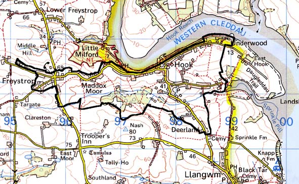
Base map reproduced from the OS map with the permission
of Ordnance Survey on behalf of The Controller of Her Majesty's Stationery
Office, © Crown Copyright 2001.
All rights reserved. Unauthorised reproduction infringes Crown Copyright
and may lead to prosecution or civil proceedings. Licence Number: GD272221
Description and essential historic landscape components
This is a relatively small, but nevertheless complex historic landscape
character area, and comprises settlements that have evolved during industrialisation
in the 19th century and early 20th century. It lies on undulating land
with a general northern aspect, between about 20m and 80m, but which in
two places runs down to the Milford Haven waterway. The settlement pattern
consists of several conjoined villages and hamlets: Hook, Freystrop, Maddox
Moor, Underwood and Deerland. Very little of the older core of these villages
now survives, apart from small clusters of mainly 19th century masonry
dwellings, often cement rendered, slate-roofed and of one or two storeys.
There are three-bay dwellings broadly in the vernacular style at Hook,
Underwood and Freystrop, and a 19th century chapel at Hook. Dense scatters
and linear development of late 20th century houses and bungalows in a
variety of styles and materials stretch between the villages and hamlets.
Many of these new dwellings are built on the sites of 19th century and
early 20th century cottages and houses, of which very little survives.
However, a few survivals, including a small single storey, timber-framed
and corrugated-iron clad cottage, indicate the modest size and quality
of much of the earlier housing stock. A caravan park, school and sports
field are included in this area. Small, irregular fields surround the
settlements. Boundaries consist of earth banks topped with hedges. Hedges
are generally well maintained, though some are becoming overgrown, and
these, together with scrubby woodland at Nash and larger trees along the
fringes of the Milford Haven waterway, lend a wooded aspect to parts of
the landscape. Agricultural land-use is almost entirely improved pasture
with pockets of poorer rushy ground. Remains of the coal mining industry,
in particular Hook Colliery, survive within this area, and include tramways
and spoil heaps. Sprinkle, Hook and Underwood were all quays for the exports
of coal, but very little of the built structures survive. At these three
locations the foreshore is either a muddy and rocky foreshore or marsh.
The launching and mooring of pleasure craft is now their main maritime
function. Apart from the industrial remains associated with the coal mining
industry, archaeology is not a major component of this area.
The settlement pattern, field systems, and industrial history and remains
distinguish this area from its neighbours. To the north woodland along
the banks of the Milford Haven waterway provides a clear and well-marked
boundary. On other sides a landscape of larger fields and farms contrasts
with this area, although no hard boundary exists, but rather a zone of
change.
Sources: Charles 1992; Edwards 1950; Edwards 1963; Freystrop Parish tithe map 1839; Llangwm Parish tithe map 1841; NLW PICTON CASTLE VOL. 1; Ordnance Survey 6” First Ed. 1869; Owen 1897; Rees 1975