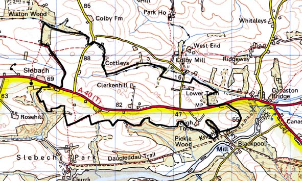
Home > Historic Landscape Characterisation > Milford Haven Area > |

TOCH 
GRID REFERENCE: SN 040155
AREA IN HECTARES: 310
Historic Background
An inland character area lying within the parish of Slebech. It comprises
fields and farms. During the medieval period the area belonged to the
Knights Hospitaller Manor of Slebech (centred on their Commandery at Slebech
Church). The farm Clerkenhill may have derived its name, which was recorded
in 1577, from the brethren. High and Lower Toch farms appear to represent
a single earlier holding, mentioned in Slebech records from the 14th century,
which suggests that Clerkenhill, on higher ground, may have previously
been open land. Cumberland farm is later still, dating from the 18th century.
The pattern of large, regular enclosures appears in general to be late,
and post-medieval in its present form. The Slebech, Newton and Minwere
parish tithe map of 1847 shows this area exactly as it is today. The main
medieval east-west route, turnpiked in the 18th century and now the A40,
passes through the area. During the First Civil War, in 1645, Parliamentary
and Royalist troops clashed at Colby Moor, just northeast of this area.
Base map reproduced from the OS map with the permission
of Ordnance Survey on behalf of The Controller of Her Majesty's Stationery
Office, © Crown Copyright 2001.
All rights reserved. Unauthorised reproduction infringes Crown Copyright
and may lead to prosecution or civil proceedings. Licence Number: GD272221
Description and essential historic landscape components
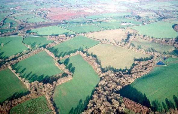
Toch historic landscape character area lies across a low, rounded ridge
that achieves heights of over 80m above sea level. The A40 runs along
the crest of the ridge and bisects this area. Dispersed farms and fields
characterise this area. Farmhouses are mostly 19th century in date, stone-built
with slate roofs, and in the Georgian vernacular tradition – i.e.
symmetrical positioning of windows, chimneys etc. Older farm buildings
consist of one or two ranges, again stone-built with slate roofs. High
Toch farmhouse, and a nearby milepost, are Grade II listed. Large modern
agricultural buildings attached to some of the farms are a feature of
the landscape. Other dwellings, in addition to the farmhouses, comprise
dispersed 19th century houses alongside the A40. Fields vary in size,
but most approximate to a rectangular shape. Boundaries are earth banks
topped with hedges. Most of the hedges are in good condition, but a significant
number are becoming overgrown and support small trees, and a small number
are derelict and are replaced by wire fences. The overgrown hedges in
conjunction with scrubby woodland on some steep slopes and in hollows
lend a wooded aspect to parts of the area. Agricultural land-use is improved
pasture with a little arable. Archaeological sites do not characterise
this area, and consist of bronze age find spots and an undated earthwork.
The definition of this area is not good. Many of its historic landscape components are also found in neighbouring areas. Generally, however, to the south the landscape consists of woodland and estate farms and parkland, whilst elsewhere the field patterns, settlement pattern and buildings are slightly different.
Sources: Charles 1948; Charles 1992; Slebech, Minwere and Newton Parishes
tithe map 1847